
2nd EF3 in CO this year (Granada on 6/23) and this after a 15 year period without one there. This has been a year for the ages in the High Plains.
Navigation
Install the app
How to install the app on iOS
Follow along with the video below to see how to install our site as a web app on your home screen.
Note: This feature may not be available in some browsers.
More options
-
Welcome to TalkWeather! We see you lurking around TalkWeather! Take the extra step and join us today to view attachments, see less ads and maybe even join the discussion. CLICK TO JOIN TALKWEATHER
You are using an out of date browser. It may not display this or other websites correctly.
You should upgrade or use an alternative browser.
You should upgrade or use an alternative browser.
Severe Weather 2023
- Thread starter KevinH
- Start date
TH2002
Member
- Messages
- 4,974
- Reaction score
- 11,116
- Location
- California, United States
- Special Affiliations
- SKYWARN® Volunteer
Previous most recent EF3 in Colorado was Berthoud in 2015, but yeah, this year has definitely been an anomaly as far as High Plains tornadoes are concerned.2nd EF3 in CO this year (Granada on 6/23) and this after a 15 year period without one there. This has been a year for the ages in the High Plains.
TH2002
Member
- Messages
- 4,974
- Reaction score
- 11,116
- Location
- California, United States
- Special Affiliations
- SKYWARN® Volunteer
Turin, NY tornado rated 138MPH EF3, which I honestly have to say seems rather lenient based on the damage I've seen. The rating was based on a townhouse that had its roof torn off and some interior walls (no exterior walls) knocked down. I have a feeling many WFO's would not have rated this damage above EF2.
CheeselandSkies
Member
(Not laughing at the damage but rather the irony given the obvious ignoring of extreme high-end/potential EF5 damage in so many surveys; Vilonia being the most egregious but far from the only example over the last 10 years)
That looks like 85 mph wind bag damageTurin, NY tornado rated 138MPH EF3, which I honestly have to say seems rather lenient based on the damage I've seen. The rating was based on a townhouse that had its roof torn off and some interior walls (no exterior walls) knocked down. I have a feeling many WFO's would not have rated this damage above EF2.
atrainguy
Member
Weather just got interesting here - I'm kind of in the path of this rotation. It may have produced already in Perry.
atrainguy
Member
Creepy looking storm.
atrainguy
Member
TH2002
Member
- Messages
- 4,974
- Reaction score
- 11,116
- Location
- California, United States
- Special Affiliations
- SKYWARN® Volunteer
(Not laughing at the damage but rather the irony given the obvious ignoring of extreme high-end/potential EF5 damage in so many surveys; Vilonia being the most egregious but far from the only example over the last 10 years)
Far as NY tornadoes are concerned, I know I've mentioned Smithfield multiple times though I can't help but bring it up again for comparison's sake: gotta love how Turin was rated EF3 by NWS Buffalo while Smithfield is officially classified as EF2 by NWS Binghamton. I think anyone would be able to tell which one was stronger:That looks like 85 mph wind bag damage

CheeselandSkies
Member
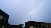
Just had the best storm of the year at home for me (beating July 28 because the lightning was just as frequent but more visible, plus we had a long-duration blast of ~40 MPH gust front winds). Heaviest part of the core with probable hail missed me to the SW.
I think I captured lightning hitting the TV broadcast tower visible from my apartment balcony (belonging to one of the competitors to where I work") ). Transferring video now.
). Transferring video now.
I think I captured lightning hitting the TV broadcast tower visible from my apartment balcony (belonging to one of the competitors to where I work
). Transferring video now.Attachments
warneagle
Member
Weather just got interesting here - I'm kind of in the path of this rotation. It may have produced already in Perry.
Well, good thing it got it out of its system yesterday since I’m driving up there today
- Moderator
- #1,352

- Moderator
- #1,354
It is SO humid out here today. No surprise storms are in the forecast.
Yeah, it's horrible!
atrainguy
Member
Got an observed tornado in Ohio right now.
Timbo64
Member
I know!Yeah, it's horrible!
Our mesh "summer" motorcycling jackets are pretty comfortable when we're roling down the road and the wind is blowing through them, but they are brutal in this heat and humidity when we're stopped at red lights that take forever to change... LOL!
For the last several weeks, my wife, Alyson, and I leave the house on the Triumph Tiger on Saturday morning to get breakfast somewhere and then have to be home by noon to beat the heat.
We just got home from a ride about five minutes ago to beat the rain that's rolling in.
 600 2000 8-12-23.jpg")
- Moderator
- #1,358
I’m glad to see NWS Nashville issue a tornado warning for that line that was doing the same exact thing about an hour ago.
Last edited:
MikeP
Member
Pretty stout cape again today....