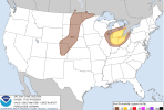
• Welcome to TalkWeather!
    We see you lurking around TalkWeather! Take the extra step and join us today to view attachments, see less ads and maybe even join the discussion.
    CLICK TO JOIN TALKWEATHER

Severe Weather 2023

It's interesting. I recall 1994 being brought up a lot as a possible analog to this year (for both severe weather and Atlantic tropical cyclones) due to the El Nino. That likewise featured a much below average "peak" severe weather season for May and early June; but then had anomalously high levels of activity develop and continue well into the summer in places where the season is typically over by that point in the year, such as the Southern Plains and mid-South.

We'll see if the Atlantic hurricane season plays out similarly, or if the anomalously warm waters throughout much of the basin promote more activity despite the El Nino.
I posted this in the tropical section but I'll post it here too.

With the first three storms of the season in the Eastern Pacific (Adrian, Beatriz, and Calvin) becoming hurricanes, it marks only the 6th year since 1950 where the first three named storms have strengthen to hurricane intensity. Other years are: 2015, 2011, 1995, 1971, and 1950. All but one (2015) were active to very active in the Atlantic.

...and I'd wager 2015 was active enough with Joaquin (most memorable in my opinion for the ship El Faro blundering into its eyewall with fatal consequences, just inexcusable that could happen in the modern age; it also devastated parts of the Bahamas but has since been roundly eclipsed in that regard by Dorian).
 
Yeah I watched a documentary with my mom about the El Faro. Numerous mistakes made plus mismanagement. 2015 was one of those years where it took one storm to make a season memorable. You take out Joaquin and it wasn't memorable.
 
Yeah I watched a documentary with my mom about the El Faro. Numerous mistakes made plus mismanagement. 2015 was one of those years where it took one storm to make a season memorable. You take out Joaquin and it wasn't memorable.

It seems to be that way in a lot of cases, whether there's an El Nino or not. Take out Ida and Ian, and 2021-22 aren't all that memorable (for the CONUS, at least), either.
 
It seems to be that way in a lot of cases, whether there's an El Nino or not. Take out Ida and Ian, and 2021-22 aren't all that memorable (for the CONUS, at least), either.

The same could be said for tornado outbreaks and even tornado seasons. All it takes is one tornado going through the wrong place at the wrong time...
 
Significant flash flood situation continuing in Mayfield this morning. Using GRlevelx Anlayst for different warning tags and GRlevelx3 for total rainfall.

Dark shade of Green is Flash Flood Warning with CONSIDERABLE tag.
Lighter but more pronounced shade of green is Flash Flood Emergency with CATASTROPHIC tag.
 

Attachments

  • Screenshot 2023-07-19 080708.png
    Screenshot 2023-07-19 080708.png
    440.5 KB · Views: 0
  • Screenshot 2023-07-19 080600.png
    Screenshot 2023-07-19 080600.png
    1.6 MB · Views: 0
Last edited:
Significant flash flood situation continuing in Mayfield this morning. Using GRlevelx Anlayst and GRlevelx3 for total rainfall.

The same area that was infamously devastated over a year and a half ago by a nocturnal tornado. Ugh...:(
 
High risk over parts of central and southern Europe today.


I wonder if the Po Valley of northern Italy is one of those geographically favored regions for severe weather, like a miniature version of the Plains of the USA. I seem to recall they were included in the only other unofficial "high risk" for severe weather I'm aware of in Europe, way back in 2003. That was issued by the European Storm Forecast Experiment (ESTOFEX). They no longer use the SPC-style category nomenclature, but they currently have a level 3 "extremely severe" (equivalent to a high risk) forecast out for this same event.

We'll have to keep an eye out and see if any significant tornadoes do end up occurring with this.
Quite a few reports of damaging wind gusts in and around Milan so far. ESTOFEX noted in their outlook that low level shear profiles aren't too favorable for tornadoes, but still mentioned that in an environment with such ample CAPE and high level shear, tornadoes (some possibly strong) can't be ruled out. I'd imagine any tornadoes that do come out of this would be rather short lived though, but we'll see...

Also very interesting to see northern Slovenia in the level 3 risk area - Slovenia isn't known for tornadoes, but they have gotten a small handful including an F3 in 2008.
 
No confirmed tornadoes from this European severe weather event so far, but definitely reports of widespread straight line wind damage. Milan is getting a second round of damaging winds as a QLCS is moving through. A long-tracked supercell also came onshore at Poreč, Croatia and tracked all the way to Ogulin, a distance of about 78 miles. Probably some large hail with that storm.
 
No confirmed tornadoes from this European severe weather event so far, but definitely reports of widespread straight line wind damage. Milan is getting a second round of damaging winds as a QLCS is moving through. A long-tracked supercell also came onshore at Poreč, Croatia and tracked all the way to Ogulin, a distance of about 78 miles. Probably some large hail with that storm.
Tired: chasing Oklahoma
Wired: chasing the high plains
Inspired: chasing Croatia
 
Checking up on the local forecast and I see that there's a potential for rough weather tomorrow in the Lower Great Lakes.


Also, don't know much about nadocast and how reliable it is, but FWIW it currently has the tornado threat concentrated on Metro Detroit.


Attachments

  • Screen Shot 2023-07-25 at 1.45.43 PM.png
    Screen Shot 2023-07-25 at 1.45.43 PM.png
    906.2 KB · Views: 0
  • Screen Shot 2023-07-25 at 1.45.48 PM.png
    Screen Shot 2023-07-25 at 1.45.48 PM.png
    740.6 KB · Views: 0
  • Screen Shot 2023-07-25 at 1.45.54 PM.png
    Screen Shot 2023-07-25 at 1.45.54 PM.png
    794.9 KB · Views: 0
  • Screen Shot 2023-07-25 at 1.45.59 PM.png
    Screen Shot 2023-07-25 at 1.45.59 PM.png
    772.4 KB · Views: 0
ESTOFEX maintains a Level 3 risk area further east today, but the main strong tornado threat will again be in northern Italy (Level 2 risk area) with any isolated supercells that form behind the QLCS. Already have two confirmed tornadoes in Poland and Estonia in the Level 1 and general thunderstorm risk areas, respectively.
showforecast.cgi


Storm Forecast
Valid: Tue 25 Jul 2023 06:00 to Wed 26 Jul 2023 06:00 UTC
Issued: Tue 25 Jul 2023 06:23
Forecaster: PUCIK
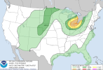
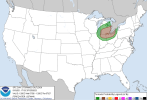
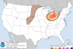
A level 3 was issued across Slovenia, N Croatia, S Hungary and W Romania mainly for damaging wind gusts, very large hail and to the lesser extent for tornadoes.

A level 2 was issued across N Italy mainly for very large hail, severe wind gusts and tornadoes. A strong tornado threat will be present along the Apennines!

A level 2 was issued across N Hungary, E Slovakia, Ukraine and N Romania mainly for damaging wind gusts, large hail and excessive rainfall.

A level 1 was issued across Belarus and W Russia for tornadoes, severe wind gusts and to the lesser degree for large hail.

A level 1 was issued for E Latvia and Lithuania mainly for heavy rainfall and marginally large hail.


*** Severe weather outbreak continues with the threat shifting further east during the day! ***

DISCUSSION

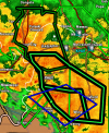
... Slovenia, N Croatia, S Hungary, NW Romania ...

A band of intense storms has entered Slovenia from N Italy. The environment ahead is characterized by >1500 J/kg of MUCAPE combined with very strong effective shear. The storms will pose a risk of very large hail. Severe wind gusts are likely despite the fact that storms may be elevated at first. As the storms move E, daytime heating over Hungary may allow for the storms to become surface based. A development of bow echo is possible given 20+ m/s of 0-3 km shear. Extremely severe wind gusts threat will thus increase towards the later hours as the system moves towards Romania. Some forecast hodographs also show around 10 m/s of 0-1 km shear and large amounts of streamwise vorticity in the inflow to the storms. This threat will be conditional upon the convective mode and whether the surface heating will allow the cloud bases to become higher.

... N Italy ...

While the main line of storms has passed towards E, high-res models still indicate a development of more isolated storms, supercells, especially along the Apennines. Will maintain a Lvl 2. Shear profiles will remain extremely conducive for supercells capable of all hazards, but increasing dryness in mid-troposphere may inhibit the activity later on. A tornado risk will be present especially along the W flank of the Apennines, where models show 10+ m/s of 0-1 km bulk shear and 150 m2/s2 of 0-500 m SRH. If an isolated supercell moves across the region, a strong tornado risk can be expected in such an environment.


... N Hungary, Slovakia, Ukraine, ...

Widespread storms are forecast to form across the area in MLCAPE around 1000 J/kg (increasing towards S) and 15 - 20 m/s of 0-6 km bulk shear. Well organised storms are forecast to form, including supercells and large convective systems, that will move NE. Ukraine may be affected by a fast-moving convective system that will emerge from Ukraine. Expect multiple threats from storms, including large hail, severe wind gusts and heavy rainfall.

... Belarus to W Russia ...

ICON-EU shows large curve in the low-level hodograph, suggestive of a tornado threat over this region. Other models are more sceptical and the area needs to be monitored for the development of supercells. More marginal severe wind gust and large hail risk would be present besides this one.

... S Germany, Alps, SW Czechia ...

Ahead of the approaching short-wave trough, along the front, scattered to widespread storms are forecast to form, in the environment of MLCAPE up to 1000 J/kg and 0-6 km shear of around 15 m/s. Expect risks of large hail and isolated severe wind gusts from stronger storms, couple of which could be supercells.

... E Latvia and E Lithuania...

Forecast profiles show around 15 m/s of 0-6 km shear, allowing for at least well-organised multicells and brief supercells not being ruled out. In such scenario, marginally large hail may occur, which is otherwise limited by skinny CAPE and low LCLs. Heavy rainfall threat will be present in multicells, especially if multiple cells cross the same area, given high RH throughout the whole troposphere.
 
I wonder if the high temps in the gulf will fuel fall severe weather if they can persist.
I think this is being forgotten. The El Nino is still in transition. It should open the Jet Stream from Mexico and the SW across the South when it changes over. I think that you are correct about the Gulf. If it stays hot, what effect will that possibly be on upcoming severe seasons? It could be a dangerous setup. el-nino.jpg
 
I think this is being forgotten. The El Nino is still in transition. It should open the Jet Stream from Mexico and the SW across the South when it changes over. I think that you are correct about the Gulf. If it stays hot, what effect will that possibly be on upcoming severe seasons? It could be a dangerous setup. View attachment 21167
Very true and even if we see a big Gulf system this season, we know that it doesn't take the Gulf that long to warm back up. However, if we don't see a big hurricane in the Gulf this year, it's gonna be trouble for Fall tornado season. 2015 is a good example of this but the Gulf wasn't as hot as it is now back in July 2015.
 
Back
Top