• Welcome to TalkWeather!
    We see you lurking around TalkWeather! Take the extra step and join us today to view attachments, see less ads and maybe even join the discussion.
    CLICK TO JOIN TALKWEATHER

Severe Weather 2023

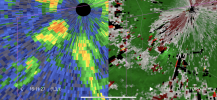
Sneaky tornado threat popped up in northern IL this afternoon. I'm currently in Davis Junction, between Rockford and Rochelle.


Sent from my Pixel 4a using Tapatalk
Was a 5% tornado area this morning before being upgraded to a 10% hatch with a 50/30 Tornado Watch to compliment. Currently waiting for a tow truck after breaking down in Riverside but hey, I got a radar app on my phone to pass the time…
 
First 10% SIG tornado hatch area in July for the Chicago area on record per IEM.
 
Quite a mesoscale uptrend day; spatially concentrated mini outbreak going on up there it seems

rap_2023071222_000_41.76--88.92.png

That will certainly do it

A few hours of sun to steepen low level lapse rates + deep moisture south of a warm front + backing right along that warm front + fairly potent (50-60kt at 500mb) shortwave trough approaching + intensifying LLJ = quite the potent enviro
 
Last edited:
First tornado in July to hit within the Chicago suburbs going back to 1950. The strongest tornado to hit the southern suburbs was the EF4 on April 21st, 1967.
 
Glimpsed the Campton Hills/Plato/South Elgin twins, unfortunately video is pretty much worthless. Was never able to stop and tripod like I was for Keota, and the roads became lined with trees seconds after I caught a view. Super jealous of Matt Zuro and Jimmy Sieniki's shots.

Still, this is why I stayed with the storm after following it from Davis Junction for over an hour and a half without it seeming much inclined to do anything.

071223TornadoGoProGrab_01.jpgMVI_1516.MP4.03_39_56_01.Still001.jpgMVI_1517.MP4.03_40_08_18.Still001.jpg
 
Back
Top