• Welcome to TalkWeather!
    We see you lurking around TalkWeather! Take the extra step and join us today to view attachments, see less ads and maybe even join the discussion.
    CLICK TO JOIN TALKWEATHER

Severe Weather 2023

KevinH

Member
Messages
1,818
Reaction score
2,890
Location
West Central GA
I can't remember who told me or where I read it, but I've heard that towards the end of a 3 year La Nina you can see more active than normal Spring tornado seasons. I'm paraphrasing there but it's something like that. I've honestly drawn a blank on where I heard it.
I think I posted about this on here before… let me check

EDIT: Yep (Note: this now links to the current outlook and not the one I posted about Sept 2022)
 
Last edited:

Gail

Member
Messages
403
Reaction score
586
Location
Caledonia, MS
Hopefully it won’t be too horrible this spring. This prequel is a little concerning though, and I can’t imagine these systems when the dynamics are spring like since some have been robust without them. I’m starting to daydream and look at jobs at Nellis AFB where I’m not under a constant barrage of tornado threats, but I know I’d miss home too much even with them.
 
Messages
300
Reaction score
866
Location
Oxford, Mississippi
1673633747610.png

Way off in +300 land....but still interesting. Shows a crashing front on January 26th with a 20 degree change. It would also stay on schedule with cyclical 6-8 day pattern we've experienced lately.
 
Last edited:
Messages
300
Reaction score
866
Location
Oxford, Mississippi
I can't remember who told me or where I read it, but I've heard that towards the end of a 3 year La Nina you can see more active than normal Spring tornado seasons. I'm paraphrasing there but it's something like that. I've honestly drawn a blank on where I heard it.
There are going to be a lot of surprises this year in tornado and hurricane forecasting. Last year was the first year 3 La Nina in recorded history as far as I know and we saw how that impacted the Atlantic hurricane season forecast. I think we are in uncharted territory when it comes to the ENSO.
 

JPWX

Member
Messages
1,512
Reaction score
4,097
Location
Smithville MS
Looking back at 3 year La Nina's (1954 to 1956, 1973 to 1976, and 1998 to 2001) and tornadic activity for the state of Mississippi. Unfortunately, I don't have any counts outside of MS.

1957: Mississippi had 216 tornadoes in April and 228 in May plus 147 in June. (1957 Atlantic Season featured 8 total systems, 3 hurricanes, and 2 majors. Notable Storms: Audrey and Carrie)

1977: Mississippi had 88 tornadoes in April and 228 in May plus 132 in June. (1977 Atlantic Season featured 16 total systems with only 6 tropical storms, 5 hurricanes, and 1 major. Notable Storms: Anita and Babe)

2002: Mississippi had 117 tornadoes in April and 204 in May plus 47 in June. (2002 Atlantic Season featured 14 total systems with only 12 tropical storms, 4 hurricanes, and 2 majors. Notable Storms: Isidore, Gustav, Kyle, and Lili)

Interestingly enough, the 2022 Atlantic Season had 16 total systems with only 14 tropical storms, 8 hurricanes, and 2 majors. This season had similarities to 1977 and 2002 in terms of total systems, tropical storms, and major hurricanes.

Mississippi has averaged 52.7 tornadoes from 1996 thru 2020. I'm unable to find the exact averages by month for April thru June.

Nationally, April averages around 191 tornadoes, May averages 273, and June averages 200.

A study I just stumbled upon on NWS Memphis site from 2012 by Ryan Husted on Mid-South Severe Climatology Study.


(Numbers reflect the count for each category and percentage of the total)

The distribution of tornadoes from 1950 to 2011 based on ENSO conditions:

ENSO Neutral has 427 (45%) with La Nina at 336 (36%) and El Nino at 178 (19%)

The distribution of months based from 1950 to 2011 based on ENSO conditions:

ENSO Neutral has 373 (50%) with La Nina at 186 (25%) and El Nino at 185 (25%)

The distribution of months based from 1955 to 2011 based on ENSO conditions:

ENSO Neutral has 351 (51%) with La Nina at 169 (25%) and El Nino at 164 (24%)

Which ENSO Conditions bring more severe weather (Average number of tornadoes per month 1950 to 2011)

Neutral: 1.15 (29%), La Nina: 1.83 (47%), and El Nino: 0.94 (24%)

The last 4 Springs that we were in Neutral ENSO conditions: 2017, 2018, 2020, and 2021.

2017: Mississippi had 192 tornadoes in March, 214 in April, and 291 in May. (January 2017 had 147 total tornadoes nationwide)

2018: Mississippi had 55 tornadoes in March, 130 in April, and 170 in May. (January 2018 had 16 total tornadoes nationwide)

2020: Mississippi had 4 tornadoes in March, 57 in April, and 0 in May. (January 2020 had 90 total tornadoes nationwide)

2021: Mississippi had 19 tornadoes in March, 5 in April, and 44 in May. (January 2021 had 16 total tornadoes nationwide)

So far, January 2023 has produced a preliminary total of 58 tornadoes (not including the total from yesterday). If the 48 reported tornadoes from yesterday are confirmed, then we would easily surpass the 2020 total with 106.
 

DetectiveWX

Member
Messages
79
Reaction score
146
Location
Atlanta GA
I had that thought...1957 and 76 were the final year la ninas transitioning into el ninos. Both we very tornadic springs with -PDO/+TNI readings present. More noteworthy was that '57 had an extremely active fall season, including the Southern IL outbreak on 12/18 (the worst mid-south in Dec. before 2021). Wonder if '23 follows suit...
 

FelipeFreitas

Member
Messages
44
Reaction score
87
Location
Florianópolis, Santa Catarina, Brazil
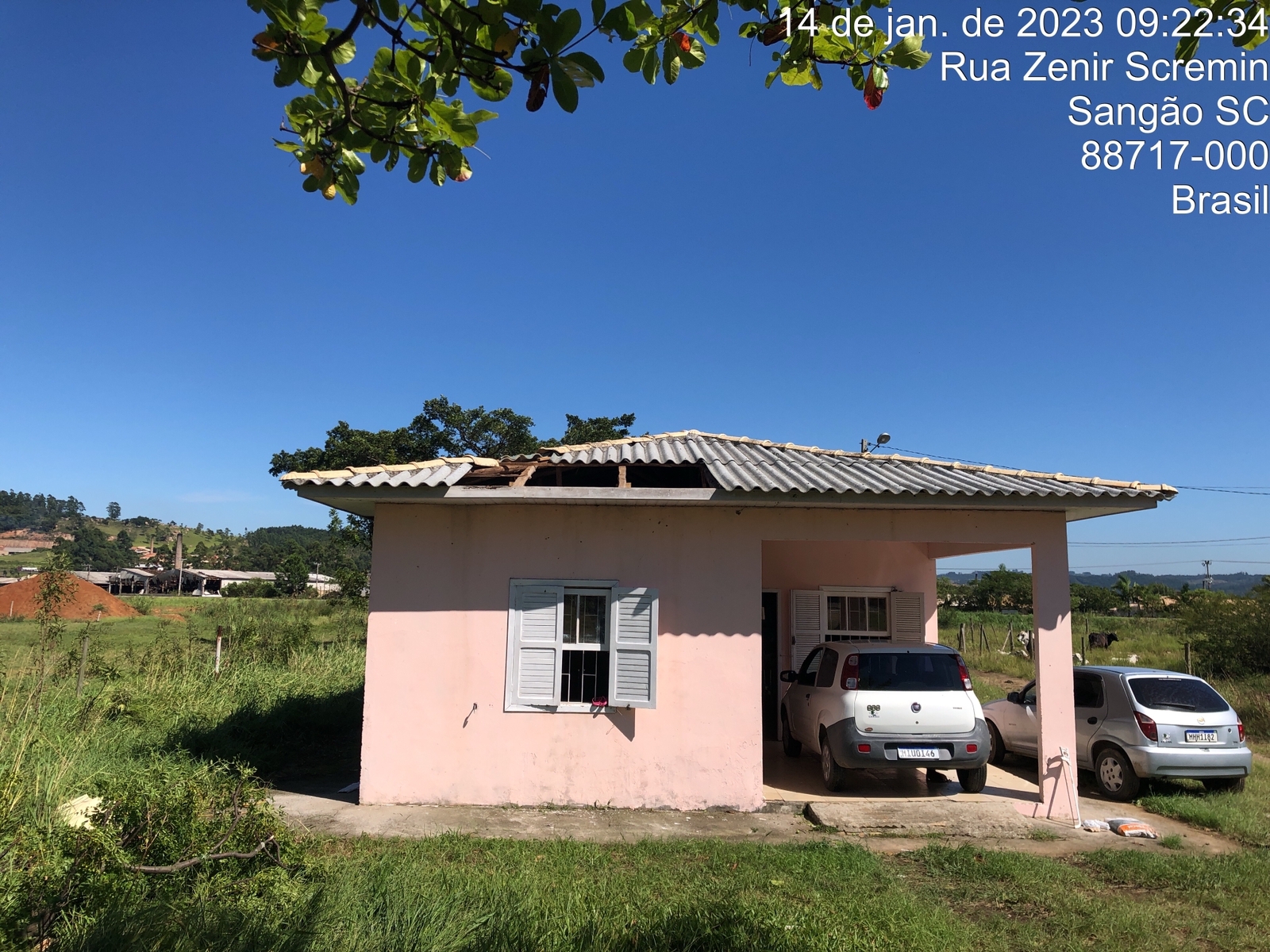
Two weak tornadoes caused damage in Sangão, Santa Catarina (south Brazil) and Palmas, Tocantins (north Brazil).

Sangão, Santa Catarina

tornado-em-Sangao.jpg.webp


sangao-JPG.JPG


tornado-em-sangao.jpeg


Palmas, Tocantins


JPWX

Member
Messages
1,512
Reaction score
4,097
Location
Smithville MS
Not sure where to post this but I guess since it has to do with severe weather, I'll post it in here. I went back through each year from 2000 thru 2022 to see how many PDS Tornado/Severe Thunderstorm Watches have been issued.

Grand Total: 282 PDS Tornado Watches and 42 PDS Severe Thunderstorm Watches (2000 through 2022)
From 2000 through 2009: 206 PDS Tornado Watches and 27 PDS Severe Thunderstorm Watches.
From 2010 through 2019: 64 PDS Tornado Watches and 11 PDS Severe Thunderstorm Watches.

Top 10 months with the highest total PDS Tornado Watches:

1. May 2003 with 34.
2. May 2004 with 16.
3. April 2011 with 12.
4. April 2001 with 8.
5. March 2005 with 8.
6. May 2008 with 8.
7. March 2006 with 6.
8. May 2007 with 6.
9. May 2010 with 6.
10. December 2002 with 6.
 

KevinH

Member
Messages
1,818
Reaction score
2,890
Location
West Central GA
Not sure where to post this but I guess since it has to do with severe weather, I'll post it in here. I went back through each year from 2000 thru 2022 to see how many PDS Tornado/Severe Thunderstorm Watches have been issued.

Grand Total: 282 PDS Tornado Watches and 42 PDS Severe Thunderstorm Watches (2000 through 2022)
From 2000 through 2009: 206 PDS Tornado Watches and 27 PDS Severe Thunderstorm Watches.
From 2010 through 2019: 64 PDS Tornado Watches and 11 PDS Severe Thunderstorm Watches.

Top 10 months with the highest total PDS Tornado Watches:

1. May 2003 with 34.
2. May 2004 with 16.
3. April 2011 with 12.
4. April 2001 with 8.
5. March 2005 with 8.
6. May 2008 with 8.
7. March 2006 with 6.
8. May 2007 with 6.
9. May 2010 with 6.
10. December 2002 with 6.
May and April…. Shocker lol

I wonder how 2023 will end up.
 

KevinH

Member
Messages
1,818
Reaction score
2,890
Location
West Central GA
Not sure where to post this but I guess since it has to do with severe weather, I'll post it in here. I went back through each year from 2000 thru 2022 to see how many PDS Tornado/Severe Thunderstorm Watches have been issued.

Grand Total: 282 PDS Tornado Watches and 42 PDS Severe Thunderstorm Watches (2000 through 2022)
From 2000 through 2009: 206 PDS Tornado Watches and 27 PDS Severe Thunderstorm Watches.
From 2010 through 2019: 64 PDS Tornado Watches and 11 PDS Severe Thunderstorm Watches.

Top 10 months with the highest total PDS Tornado Watches:

1. May 2003 with 34.
2. May 2004 with 16.
3. April 2011 with 12.
4. April 2001 with 8.
5. March 2005 with 8.
6. May 2008 with 8.
7. March 2006 with 6.
8. May 2007 with 6.
9. May 2010 with 6.
10. December 2002 with 6.
And while we are talking about PDS:

It would be nice if all NWS offices could get on the same page and agree on a definition of and when to use PDS/Emergency wording in warnings. THEN educate the public to minimize if not eliminate confusion and ambiguity across the US.

I think this synergy will increasingly be needed in the future as storms (may) become more severe and/or frequent.
 

JPWX

Member
Messages
1,512
Reaction score
4,097
Location
Smithville MS
And while we are talking about PDS:

It would be nice if all NWS offices could get on the same page and agree on a definition of and when to use PDS/Emergency wording in warnings. THEN educate the public to minimize if not eliminate confusion and ambiguity across the US.

I think this synergy will increasingly be needed in the future as storms (may) become more severe and/or frequent.
I'd be interested to know what the criteria is if any for each office is for Tornado Emergencies. I know NWS Memphis didn't issue one for the Smithville, MS tornado during the Super Outbreak which honestly surprised me a little.
 

KevinH

Member
Messages
1,818
Reaction score
2,890
Location
West Central GA
I'd be interested to know what the criteria is if any for each office is for Tornado Emergencies. I know NWS Memphis didn't issue one for the Smithville, MS tornado during the Super Outbreak which honestly surprised me a little.
Right. A consistent standard across the board would be nice lol
 

Clancy

Member
Messages
2,621
Reaction score
4,723
Location
Macland, Georgia
I think ashtonlemleywx mentioned earlier, this is way off in voodoo land, but this system has remained present over several runs, with the GFS dropping it further south over the last couple of runs, and it looks a bit spooky.
1673752136367.png
 
Messages
2,853
Reaction score
4,636
Location
Madison, WI
...or Dec. 2021 when a tornado emergency wasn't issued for Mayfield until it was a couple minutes, if that, from town. Although it's unlikely that any individual at home would have taken any action that they hadn't already for the "regular" tornado warning, perhaps with more lead time it might have jarred, say, the management at Mayfield Consumer Products into getting the staff into more adequate shelter.

It also appears some offices don't use the tornado emergency at all, "maxing out" with the PDS warning. On the flip side, we had the two TOREs issued in four days in Arkansas last April, neither of which were actually producing strong tornadoes. Although in at least one of those cases, the office received false/unreliable spotter reports.
 

Sawmaster

Member
Messages
516
Reaction score
660
Location
Pickens SC
Special Affiliations
  1. SKYWARN® Volunteer
Consistency and the NWS are polar opposites. Even supposedly clear and settled things like rating tornado damage according to specific criteria doesn't happen consistently there. People on the street generally don't have a clue about what a PDS implies but nearly everyone understands what "emergency" means. Remembering that they are afflicted heavily with the "Plainfield syndrome" it won't be long before every QLCS notch or hook formation and every supercell with a hint of rotation becomes a "PDS tornado warning emergency" to which most people won't pay much attention to either.

The system is broken and until you fix that first they're wasting their time doing anything else :(
 

JPWX

Member
Messages
1,512
Reaction score
4,097
Location
Smithville MS
Well the 18z GFS has a very active southern jet and pattern through the end of the month with 4 additional storm systems including next week's. Each one of these will have potential for severe weather across you know Dixie Alley. Instability may be an issue but still as we have recently seen lack of instability was handled poorly by modeling.
gfs-deterministic-conus-z500_speed-4118800.pnggfs-deterministic-conus-z500_speed-4669600.pnggfs-deterministic-conus-z500_speed-4993600.pnggfs-deterministic-conus-z500_speed-5101600.png
 

KevinH

Member
Messages
1,818
Reaction score
2,890
Location
West Central GA

Clancy

Member
Messages
2,621
Reaction score
4,723
Location
Macland, Georgia
Well the 18z GFS has a very active southern jet and pattern through the end of the month with 4 additional storm systems including next week's. Each one of these will have potential for severe weather across you know Dixie Alley. Instability may be an issue but still as we have recently seen lack of instability was handled poorly by modeling.
*Squints* Aye yai yai.
 
Back
Top