• Welcome to TalkWeather!
    We see you lurking around TalkWeather! Take the extra step and join us today to view attachments, see less ads and maybe even join the discussion.
    CLICK TO JOIN TALKWEATHER
Logo 468x120

Severe Weather 2022

The severe weather season for year 2022 will be?

  • Above Average

    Votes: 15 68.2%
  • Average

    Votes: 7 31.8%
  • Below Average

    Votes: 0 0.0%

  • Total voters
    22
  • Poll closed .
Status
Not open for further replies.

KevinH

Member
Messages
1,816
Reaction score
2,888
Location
West Central GA
The 18z and 00z GFS runs followed with the drastic changes that we saw in the 12z run adding confidence that we have made a substantial move toward a potentially significant severe weather threat next Monday.
I know it’s far away but any idea where the models say could be at risk?
 

JPWX

Member
Messages
1,504
Reaction score
4,073
Location
Smithville MS
Day 7 area and Day 4-8 discussion from SPC. Also of note, since the implementation of the Day 4-8 outlook in Spring 2005, this is the first time ever that SPC has gone with a Day 7 15% risk in the month of December.
 

Attachments

  • spc-scentus-spc_day7_prob-0320740.png
    spc-scentus-spc_day7_prob-0320740.png
    109 KB · Views: 0
  • 202212060959_SWOD48.png
    202212060959_SWOD48.png
    64 KB · Views: 0

Fred Gossage

Member
Meteorologist
PerryW Project Supporter
Messages
597
Reaction score
2,117
Location
Florence, AL
Day 7 area and Day 4-8 discussion from SPC. Also of note, since the implementation of the Day 4-8 outlook in Spring 2005, this is the first time ever that SPC has gone with a Day 7 15% risk in the month of December.
Don't read too much into that though. They have adopted a philosophy change over the past several months (and have said so at times in tweets from staffer accounts) in which they will flag extended range threats with 15% probabilities more often, when there is enough ensemble support to flag what would be the equivalent of a D1 15% when said threat would get into the D1 outlook range. Flagging a threat at Day 5+ isn't a harbinger of a higher-end risk coming anymore. If a 30% is flagged in advance like that, that's a bit of a different story though.

Also, not pertaining to this event but for future reference when we get 30% risks and want to do comparisons and such, prior to the Day 4-8 being divided into 15 and 30 percent areas, every outlined area in the Day 4-8 range was a 30 percent.
 

JBishopwx

Member
Sustaining Member
Messages
894
Reaction score
2,011
Location
Ackerman, MS
Special Affiliations
  1. SKYWARN® Volunteer

JPWX

Member
Messages
1,504
Reaction score
4,073
Location
Smithville MS
Don't read too much into that though. They have adopted a philosophy change over the past several months (and have said so at times in tweets from staffer accounts) in which they will flag extended range threats with 15% probabilities more often, when there is enough ensemble support to flag what would be the equivalent of a D1 15% when said threat would get into the D1 outlook range. Flagging a threat at Day 5+ isn't a harbinger of a higher-end risk coming anymore. If a 30% is flagged in advance like that, that's a bit of a different story though.

Also, not pertaining to this event but for future reference when we get 30% risks and want to do comparisons and such, prior to the Day 4-8 being divided into 15 and 30 percent areas, every outlined area in the Day 4-8 range was a 30 percent.
Ah okay. Thanks for clarifying.
 

Sawmaster

Member
Messages
516
Reaction score
660
Location
Pickens SC
Special Affiliations
  1. SKYWARN® Volunteer
when there is enough ensemble support to flag what would be the equivalent of a D1 15% when said threat would get into the D1 outlook range.
Had to read that twice but it does make sense to use one standard. It's exactly this kind of info and knowledge sharing that induced me to join here. Many thanks Fred :)
 
Messages
2,851
Reaction score
4,624
Location
Madison, WI
Before the last system I joked that late November through mid December is the new April/May...but it really seems to be true. Next Monday/Tuesday are almost eerily similar to last 12/10 and 12/15 rolled into one system according to the GFS.

I guess keeping the car prepped for chasing while Christmas shopping is the new normal.
 

Taylor Campbell

Moderator
Moderator
PerryW Project Supporter
Messages
2,112
Reaction score
2,216
Location
Wedowee, AL
Special Affiliations
  1. SKYWARN® Volunteer
Large changes of this system continue in the model data. Today, we have moved toward a Tuesday start date instead of Monday. The SPC’s Day 7 outlook today looks like it’ll be the Day 7 outlook tomorrow. :rolleyes:
 
Last edited:

Tennie

Member
Messages
960
Reaction score
791
Location
Tennessee
It looks like the SPC has stuck with 15% for Day 6, along with adding a 15% for Day 7:

day6prob.gifday7prob.gif

ZCZC SPCSWOD48 ALL
ACUS48 KWNS 071007
SPC AC 071007

Day 4-8 Convective Outlook
NWS Storm Prediction Center Norman OK
0407 AM CST Wed Dec 07 2022

Valid 101200Z - 151200Z

...DISCUSSION...
A increase in divergence of solutions amongst medium-range models,
and an increase in ensemble spread, is noted as compared to 24 hours
prior, along with a general slowing of the advance of the western
U.S. trough.

In general, models forecast a very gradual amplification of the flow
field Days 4-5 and into Day 6, as short-wave energy digs
south-southeastward in the vicinity of the western North America
Coast Day 4/Saturday, and then begins to pivot a bit more
southeastward into the western U.S. Day 5/Sunday.

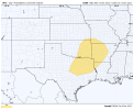
On Day 6/Monday, a more eastward advance of a large closed low will
commence, with pronounced height falls reaching the central and
southern Plains -- particularly through the evening/overnight hours.
This eastward advance appears likely to be accompanied by strong
central High Plains cyclogenesis, with a cold front to advance into
(GFS) or across (ECMWF) the southern Plains region through the
second half of the period. Based on this current pace of advance of
the synoptic features, most of the severe risk Monday would appear
to exist after dark, spreading across parts of eastern Oklahoma and
North Texas, and possibly (per the ECMWF) into western Arkansas.
Given favorable northward advection of high theta-e air, and very
strong deep-layer shear, all-hazards severe potential would be
expected.

Continued advance, and additional deepening, of the upper low is
expected Tuesday/Day 7, with the surface low progged to occlude over
the central Plains and a cold front to sweep eastward to the Mid
Mississippi Valley region after dark. With a moist warm sector
likely to reside across East Texas/Arkansas/Louisiana in this
scenario, and given the very strong wind field accompanying the
intensifying synoptic features, all-hazards severe risk including
tornado potential would exist.

By Day 8, model differences increase, casting additional uncertainty
into the forecast. With that said, it does appear that much more
limited moisture/instability will exist ahead of the system -- in
part due to a strong antecedent ridge of surface high pressure. As
such, a diminished severe risk would appear to exist for Day 8.

..Goss.. 12/07/2022
 
Status
Not open for further replies.
Back
Top