• Welcome to TalkWeather!
    We see you lurking around TalkWeather! Take the extra step and join us today to view attachments, see less ads and maybe even join the discussion.
    CLICK TO JOIN TALKWEATHER
Logo 468x120

Severe Weather 2022

The severe weather season for year 2022 will be?

  • Above Average

    Votes: 15 68.2%
  • Average

    Votes: 7 31.8%
  • Below Average

    Votes: 0 0.0%

  • Total voters
    22
  • Poll closed .
Status
Not open for further replies.

Taylor Campbell

Moderator
Moderator
PerryW Project Supporter
Messages
2,102
Reaction score
2,189
Location
Wedowee, AL
Special Affiliations
  1. SKYWARN® Volunteer
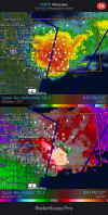
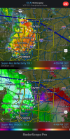
Late night confirmed tornado. If still down looks very close to Fort Thompson.

204
WFUS53 KABR 130501
TORABR
SDC017-059-069-085-130530-
/O.NEW.KABR.TO.W.0024.220613T0501Z-220613T0530Z/

BULLETIN - EAS ACTIVATION REQUESTED
Tornado Warning
National Weather Service Aberdeen SD
1201 AM CDT Mon Jun 13 2022

The National Weather Service in Aberdeen has issued a

* Tornado Warning for...
Southwestern Hand County in central South Dakota...
Southeastern Hyde County in central South Dakota...
Northeastern Lyman County in central South Dakota...
Northwestern Buffalo County in central South Dakota...

* Until 1230 AM CDT.

* At 1200 AM CDT, a confirmed tornado was located west of Lower
Brule, moving northeast at 45 mph.

HAZARD...Damaging tornado and quarter size hail.

SOURCE...Weather spotters confirmed tornado. At 1150pm, a
tornado was reported 10 miles west of Lower Brule.

IMPACT...Flying debris will be dangerous to those caught without
shelter. Mobile homes will be damaged or destroyed.
Damage to roofs, windows, and vehicles will occur. Tree
damage is likely.

* The tornado will be near...
Tailrace Rec Area around 1205 AM CDT.
Fort Thompson around 1210 AM CDT.
Lees Corner around 1215 AM CDT.

PRECAUTIONARY/PREPAREDNESS ACTIONS...

Heavy rainfall may hide this tornado. Do not wait to see or hear the
tornado. TAKE COVER NOW!
 

Avon

Member
Messages
34
Reaction score
43
Location
Not your neighborhood
Yup they definitely did
They're banking on that one cell in Wisconsin to grow upscale and blast southeast into to Mod. Risk area. Though there are still uncertainties with how this will play out.
 

Taylor Campbell

Moderator
Moderator
PerryW Project Supporter
Messages
2,102
Reaction score
2,189
Location
Wedowee, AL
Special Affiliations
  1. SKYWARN® Volunteer
Wow two beastly damaging wind producers.
 

Attachments

  • 3FD8956B-DF92-4CE7-AB5F-8A127B59076B.png
    3FD8956B-DF92-4CE7-AB5F-8A127B59076B.png
    2.5 MB · Views: 0
  • 794142B8-063B-48D1-AA01-EEE4D84E21A0.png
    794142B8-063B-48D1-AA01-EEE4D84E21A0.png
    4.4 MB · Views: 0

xJownage

Member
Messages
570
Reaction score
604
Location
Jacksonville, Florida
Now we have a tornadic supercell topped over 70,000 feet heading for Chicago.
cee03124290ba78bc769591ee589bea5-jpg.jpg


This was one of the most terrifying scans I've seen in recent memory. A rapidly tightening meso going into the chicago metro. During rush hour. This could've been a major, major disaster.

Luckily, even at this time, it was outflow dominant and got undercut. It seemed like an almost hybrid structure rather than fully supercellular, as there were multiple instances in which it displayed a rear inflow jet.
 

atrainguy

Member
Messages
718
Reaction score
1,021
Location
Linden, MI
Looking through Twitter, I see that tomorrow has a pretty decent severe risk, with a 10% tornado risk in Wisconsin and a little bit into Michigan, Minnesota and Iowa.


xJownage

Member
Messages
570
Reaction score
604
Location
Jacksonville, Florida
Looking through Twitter, I see that tomorrow has a pretty decent severe risk, with a 10% tornado risk in Wisconsin and a little bit into Michigan, Minnesota and Iowa.


I was forecasting this last night. The more I look the more confident I am in a significant tornado parameter space materializing in WI tomorrow. well timed 500mb trough ejection into an uncapped environment with 5000 cape. Hodos are as good as you can ask for. storm motion is going to be around 50mph, and the storms will likely be HP. I'm hoping they stay further north away from the population centers on the east coast of WI.
 
Messages
2,753
Reaction score
4,291
Location
Madison, WI
I was forecasting this last night. The more I look the more confident I am in a significant tornado parameter space materializing in WI tomorrow. well timed 500mb trough ejection into an uncapped environment with 5000 cape. Hodos are as good as you can ask for. storm motion is going to be around 50mph, and the storms will likely be HP. I'm hoping they stay further north away from the population centers on the east coast of WI.
Awful terrain in most of that area, as of now I'm planning to target the IA/MN portion and hope something goes there.

Sent from my Pixel 4a using Tapatalk
 

xJownage

Member
Messages
570
Reaction score
604
Location
Jacksonville, Florida
Awful terrain in most of that area, as of now I'm planning to target the IA/MN portion and hope something goes there.

Sent from my Pixel 4a using Tapatalk
not just awful terrain, but add 50+ mph storm motions and HP supercells. This would end up more like a dixie chase than anything else.
 

Tennie

Member
Messages
935
Reaction score
761
Location
Tennessee
Today's D1 outlook calls for, among other things, an ENH across much of Wisconsin with all hazards possible:

day1otlk_1300.gifday1probotlk_1300_torn.gifday1probotlk_1300_wind.gifday1probotlk_1300_hail.gif

SPC AC 151233

Day 1 Convective Outlook
NWS Storm Prediction Center Norman OK
0733 AM CDT Wed Jun 15 2022

Valid 151300Z - 161200Z

...THERE IS AN ENHANCED RISK OF SEVERE THUNDERSTORMS THIS AFTERNOON
AND EVENING OVER PARTS OF THE UPPER MIDWEST...

...THERE IS A SLIGHT RISK OF SEVERE THUNDERSTORMS THIS AFTERNOON AND
EARLY EVENING OVER PORTIONS OF THE SOUTHEAST STATES....

...SUMMARY...
Scattered severe thunderstorms are expected today across parts of
the Upper Midwest into Upper Michigan. Several tornadoes, large to
very large hail, and damaging winds all appear likely. Some of the
tornadoes could be strong.

...Upper Midwest...
Morning surface analysis shows a precipitation-reinforced boundary
extending from central IA into WI. This boundary will move only
slightly northward this afternoon as a strong shortwave trough
currently over CO approaches. Increasing low-level winds and
cyclogenesis along the boundary will lead to thunderstorm
development by mid-afternoon from western WI into northeast IA.
High and mid clouds will limit heating somewhat. However, dewpoints
in the lower 70s and steep mid-level lapse rates will yield MLCAPE
values of 3000+ J/kg. Strong deep-layer shear and large hodographs
will promote supercells capable of very large hail and a few
tornadoes (some strong) during the first several hours of the event.
It is not clear how long activity will remain discrete before
upscale organization occurs, with an increasing risk of damaging
winds. Storms will move into Lower MI after dark, with a continued
risk of locally damaging wind gusts.

...Southeast States...
A hot and humid low-level air mass will be present today from the
Carolinas southwestward into MS/AL, with widespread temperatures in
the 90s and dewpoints in the upper 60s and lower 70s. This will
result in MLCAPE values over 2000 J/kg and steep low-level lapse
rates throughout the region. The details of the timing and location
of convective development is uncertain this morning, but at least
isolated thunderstorms are expected throughout the area.
Sufficiently strong northeasterly flow aloft will aid in
southwestward-propagating clusters capable of strong/damaging wind
gusts.

..Hart/Mosier.. 06/15/2022

CLICK TO GET WUUS01 PTSDY1 PRODUCT

NOTE: THE NEXT DAY 1 OUTLOOK IS SCHEDULED BY 1630Z
CURRENT UTC TIME: 1334Z (8:34AM), RELOAD THIS PAGE TO UPDATE THE TIME
 

xJownage

Member
Messages
570
Reaction score
604
Location
Jacksonville, Florida
Today's D1 outlook calls for, among other things, an ENH across much of Wisconsin with all hazards possible:

View attachment 14531View attachment 14533View attachment 14534View attachment 14535
They shrunk the northern end of the enhanced. Today seems to have downtrended from where it was 24h ago. SFC winds are not expected to back nearly as much as previously thought, and the 500mb trough looks weaker as well. Probably for the best given the east coast of central WI is pretty heavily populated south of green bay.
 

Tennie

Member
Messages
935
Reaction score
761
Location
Tennessee
They shrunk the northern end of the enhanced. Today seems to have downtrended from where it was 24h ago. SFC winds are not expected to back nearly as much as previously thought, and the 500mb trough looks weaker as well. Probably for the best given the east coast of central WI is pretty heavily populated south of green bay.

After looking through some of the forecasts and discussions on other weather forums, this one looks like it could line out fairly quickly, and even if things remain discrete, the terrain isn't exactly suitable for chasing (meaning that any tornadoes that do form today are unlikely to be captured on a live feed). However, the storms haven't even formed yet, so we shall see...(knock on wood!)
 

xJownage

Member
Messages
570
Reaction score
604
Location
Jacksonville, Florida
After looking through some of the forecasts and discussions on other weather forums, this one looks like it could line out fairly quickly, and even if things remain discrete, the terrain isn't exactly suitable for chasing (meaning that any tornadoes that do form today are unlikely to be captured on a live feed). However, the storms haven't even formed yet, so we shall see...(knock on wood!)
It looks like the timing and location of the forcing is a little bit off as well. Further NW than expected. So we're seeing this become less confident on both a mesoscale and synoptic scale level.

The CAMs are still super consistent with prefrontals ahead of a QLCS on the front with some very prominent embedded discrete structures. I'm just watching the SFC winds, anywhere they back will have significant tornado potential. With the CAMs being so consistent, the SPC has mentioned that the 1630Z outlook will include a MDT for WI in their latest MCD for that area.
 
Status
Not open for further replies.
Back
Top