
Navigation
Install the app
How to install the app on iOS
Follow along with the video below to see how to install our site as a web app on your home screen.
Note: This feature may not be available in some browsers.
More options
-
Welcome to TalkWeather! We see you lurking around TalkWeather! Take the extra step and join us today to view attachments, see less ads and maybe even join the discussion. CLICK TO JOIN TALKWEATHER
You are using an out of date browser. It may not display this or other websites correctly.
You should upgrade or use an alternative browser.
You should upgrade or use an alternative browser.
Severe Weather 2022
- Thread starter Taylor Campbell
- Start date
- Status
- Not open for further replies.

atrainguy
Member
TornadoFan
Member
Minco, Oklahoma and Yukon should be getting their tornado precautions ready.
TornadoFan
Member
Tornado warned storm headed right for the OKC metro, including Moore.
atrainguy
Member
atrainguy
Member
atrainguy
Member
Meanwhile in Wisconsin and Minnesota
atrainguy
Member
Looks I MIGHT have some storms to watch out for today (I'm near Flint).
Last edited:
Equus
Member
Fascinating very clear downburst signature last night at 8:25ish from Norman terminal radar JUST east of the radar site, don't see a rapidly developing low level intense divergence signature this clear very often

CheeselandSkies
Member
Next Friday and Saturday look somewhat interesting in the Plains/Midwest, could see something similar to the 4/12-13 sequence or the one we just had. Remains to be seen if anything higher-ceiling can take shape.
SouthFLwx
Member
Seems like most higher-end events are taking place in the Southeast nowadays, so I wouldn’t be surprised if this potential upcoming event in the Plains isn’t all that significant.
CheeselandSkies
Member
Seems like most higher-end events are taking place in the Southeast nowadays, so I wouldn’t be surprised if this potential upcoming event in the Plains isn’t all that significant.
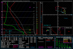
Yep. That said, here are a couple of forecast soundings for KS/OK off the 06Z GFS. Now, whether these actually verify as something similar and whether there are sustained storms in the proper mode to take advantage of this environment is another matter.
There's a lot to like about these (if you're a chaser). T/Td spreads aren't too high, critical angles are in the ballpark. The TOR sounding (over OK) actually has more SRH than the PDS TOR sounding (over KS), but more CINH as well which seems to be the difference.
Attachments
SouthFLwx
Member
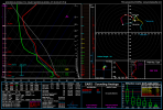
Yeah, seems like it’s another situation where it all depends on if the cap breaks or not (I’m not a chaser btw lol).Yep. That said, here are a couple of forecast soundings for KS/OK off the 06Z GFS. Now, whether these actually verify as something similar and whether there are sustained storms in the proper mode to take advantage of this environment is another matter.
There's a lot to like about these (if you're a chaser). T/Td spreads aren't too high, critical angles are in the ballpark. The TOR sounding (over OK) actually has more SRH than the PDS TOR sounding (over KS), but more CINH as well which seems to be the difference.
Last edited:
- Thread starter
- Moderator
- #354
Severe weather prospects for the month of May are looking up. This look for next Monday is gnarly!


CheeselandSkies
Member
Despite the somewhat less than ideal large-scale pattern (mainly related to the persistent -NAO), SPC's 4-8 this morning actually looks seasonably active for the end of April and early May.
SouthFLwx
Member
Definitely seems like a change from last year. Lol
CheeselandSkies
Member
Watching Saturday locally due to the last couple runs of the NAM bringing it in range...not a perfect setup but as depicted there is decent mid/upper diffluence and lapse rates over the warm sector, and the left exit region of the 500mb jet is over S WI/N IL. If that verifies, SPC's Day 4 outlook area is way too far south.
tennessee storm chaser
Member
- Messages
- 1,877
- Reaction score
- 4,288
- Location
- jackson tennessee
- Special Affiliations
- SKYWARN® Volunteer
I’ve seen better shear values also … maybe a bit lacking .Watching Saturday locally due to the last couple runs of the NAM bringing it in range...not a perfect setup but as depicted there is decent mid/upper diffluence and lapse rates over the warm sector, and the left exit region of the 500mb jet is over S WI/N IL. If that verifies, SPC's Day 4 outlook area is way too far south.
Last edited:
The deeper you get into spring, the less the -NAO matters (to an extent). Once you start getting into May, the coastal waters off the Atlantic coast are warmer and support higher dewpoints, and as long as the pattern isn't so highly amplified that you are directly recirculating continental air back into the Gulf, you can still get high enough dewpoints, even if you're pulling from the Atlantic. I don't see anything that stands out as a widespread high-impact day, but I think we will have multiple threats from the Plains eastward, and like Friday's setup, I could see us easily sneaking a violent tornado or two out of what would seem like a lower-end day because of capping concerns or storm coverage.Despite the somewhat less than ideal large-scale pattern (mainly related to the persistent -NAO), SPC's 4-8 this morning actually looks seasonably active for the end of April and early May.
tennessee storm chaser
Member
- Messages
- 1,877
- Reaction score
- 4,288
- Location
- jackson tennessee
- Special Affiliations
- SKYWARN® Volunteer
Also a negative nao would also keep Dixie and midsouth Tennessee valley regions in play longer this spring, keeping storm track and jet stream further south…. Cape won’t be much problem with it being later spring seasonThe deeper you get into spring, the less the -NAO matters (to an extent). Once you start getting into May, the coastal waters off the Atlantic coast are warmer and support higher dewpoints, and as long as the pattern isn't so highly amplified that you are directly recirculating continental air back into the Gulf, you can still get high enough dewpoints, even if you're pulling from the Atlantic. I don't see anything that stands out as a widespread high-impact day, but I think we will have multiple threats from the Plains eastward, and like Friday's setup, I could see us easily sneaking a violent tornado or two out of what would seem like a lower-end day because of capping concerns or storm coverage.
- Status
- Not open for further replies.