aujerm
Member
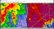
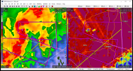
Small CC drop near Beaumont, MS right now.

Follow along with the video below to see how to install our site as a web app on your home screen.
Note: This feature may not be available in some browsers.
Small CC drop near Beaumont, MS right now.

As I say this, there's not a lot of focus for initiation at this point. A mesolow was expected to fire storms in the E OK/E KS areas, but that mesolow is coming in further north than forecast. There's still a chance that this can initiate as there's a vort max currently diving into KS but initiation has become very conditional.Tomorrow is a major sleeper chase day in NE OK. The latest HRRR run depicts a very odd setup, with what appears to be a N/S oriented Warm Front in NE OK into far SE KS (somebody please correct me if I'm seeing this improperly). The EML is fairly strong further south, but subtle forcing along the front will likely allow for initiation in SE KS. Storm motions are SE which is actually great for spotting. The dynamics are actually very good along the WF, where helicity is greatest.
View attachment 13537
This sounding is slightly contaminated, and I'm having trouble finding one that's not contaminated on the WF, but this does allow for a decent picture of the low level parameters associated with this setup. It's currently only a 2% tornado probability but I'd be gearing up to chase if I was in the oklahoma area already.'
Meanwhile, the NAM puts a decent dryline setup in central OK. It's definitely a complex forecast but overall OK seems to have some tornado potential for tomorrow. Definitely something to watch for.
I would start with the SPC storm reports summaries. A bit tedious but you should be able to drill in to each year and see a map of annual tornado reports for each state and county.Feels like it’s been abnormally slow for North AL for tornadoes over the past few springs. Is there a website or database that would show the last confirmed tornadoes for Limestone, Lawrence, or Morgan counties?
Sent from my iPhone using Tapatalk
Feels like it’s been abnormally slow for North AL for tornadoes over the past few springs. Is there a website or database that would show the last confirmed tornadoes for Limestone, Lawrence, or Morgan counties?
Sent from my iPhone using Tapatalk

yeah that central plains ridge means buisness this late spring summer. starting to wonder if we are done with severe weather here in dixie and the midsouth area??
This doesn't seem to bode well for chase season in the plains.
O yeah I agree with u, May 25 th 2011 was as big setup remember it well …. But the cap was just little to strong for most part if I can remember correctly . Just seems we can’t get out this negative nao setup . Not say we can still have a significant severe eventI'm not too sure we're finished yet. Parts of central MS saw a Moderate Risk on May 4th, 2021 and a MCS event on May 27th, 2017. Smithville MS had a brief tornado on May 25th, 2015. Our last May Moderate to High Risk for the Mid-South area was on May 25th, 2011. I know in May everyone talks about "Tornado Alley" because it's the normal hotspot but clearly you can have significant severe wx events in Dixie/Mid-South areas in May.
O yeah I agree with u, May 25 th 2011 was as big setup remember it well …. But the cap was just little to strong for most part if I can remember correctly . Just seems we can’t get out this negative nao setup . Not say we can still have a significant severe event