- Admin
- #1,321
- Messages
- 3,618
- Reaction score
- 3,431
- Location
- Fayetteville, AR
- Special Affiliations
- SKYWARN® Volunteer
Totally doableAs a Floridian, I’m thinking of changing my user name to Wind Driven Coconut.
Sent from my iPhone using Tapatalk
Follow along with the video below to see how to install our site as a web app on your home screen.
Note: This feature may not be available in some browsers.
Totally doableAs a Floridian, I’m thinking of changing my user name to Wind Driven Coconut.
Sent from my iPhone using Tapatalk
An early morning tornado injured one in south Fort Myers, FL and a wind driven coconut damaged a car in Miami.
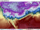
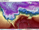
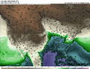
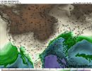
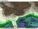
Details and potential area of impact for us novices please…Looks like trouble brewing on today’s 12z euro In extended period …
")
Looks like trouble brewing on today’s 12z euro In extended period …
Agree with u. Just put more merit with euro at this range … but gfs has same idea no doubt . Got my attention for sureThis isn't just a EURO thing. We are getting a lot of signals for an extended return flow and a period of above average temperatures next week. Moisture levels look plentiful. Should energy ejection from the west misbehave watch out!
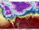
It is possible that there will be several shortwave impulses rather than a single consolidated ejection. The LR EPS hints at a cutoff under the NPAC blocking ridge.Seems to be a good bit of variability at this range with trough evolution. One thing for sure though is quality moisture return will be in place. Days upon days of return flow from the south.

That’s the pre curser to potentially a big severe outbreak towards new years
YepThat’s the pre curser to potentially a big severe outbreak towards new years
Not to mention a lot of people will be focused on the Crimson Tide playoff game that afternoon.I REALLY hope there's not a severe threat on New Year's Eve, because so many people are going to be partying and NOT paying attention!
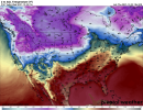
Looking at the 18z GFS temperature and dewpoints, this looks like this could be a multi day severe weather threat as well.