
The CIPS at Day 8 is already picking up on it too.The 12z euro today long range starting pick up a severe wx threat around Xmas or just after … parts Dixie Tennessee valley
Navigation
Install the app
How to install the app on iOS
Follow along with the video below to see how to install our site as a web app on your home screen.
Note: This feature may not be available in some browsers.
More options
-
Welcome to TalkWeather! We see you lurking around TalkWeather! Take the extra step and join us today to view attachments, see less ads and maybe even join the discussion. CLICK TO JOIN TALKWEATHER
You are using an out of date browser. It may not display this or other websites correctly.
You should upgrade or use an alternative browser.
You should upgrade or use an alternative browser.
Severe Weather 2021
- Thread starter Fred Gossage
- Start date
-
- Tags
- severe weather
KevinH
Member
They may use other tools besides radar when deciding to issue warnings. Let them do the job you don’tNot sure why. Storm has 28 mph max shear. Just Bc it has a hook doesn’t mean it should be warned. They issue for anything down south
")
tennessee storm chaser
Member
- Messages
- 1,877
- Reaction score
- 4,283
- Location
- jackson tennessee
- Special Affiliations
- SKYWARN® Volunteer
12 z euro continued look interesting right after Christmas . That’s going be next time frame we need watch out for …
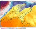
12z Euro valid around the 28th. Whenever you have temperatures and dewpoints in the 60s/70s to near 80 during the winter months, you'll have trouble.
Attachments
KevinH
Member
I almost messaged you on Twitter about this comment not realizing who you were12z Euro valid around the 28th. Whenever you have temperatures and dewpoints in the 60s/70s to near 80 during the winter months, you'll have trouble.

Yep. I'm that guy that is always talking about or bringing up long range threats. LOL!I almost messaged you on Twitter about this comment not realizing who you were
CheeselandSkies
Member
Yep. I'm that guy that is always talking about or bringing up long range threats. LOL!
That guy who was doing it oh...about 10 years and 8 months ago? That kid they wrote about in "What Stands in a Storm?" Great to know you are still pursuing your passion. Although I'm sure that day was incredibly traumatic, you went above and beyond to help warn your town.
As for those Euro maps...just the surface low placement and surface thermos is a big yikes for parts of the South if that verifies.
KevinH
Member
LA, MS, TN right?That guy who was doing it oh...about 10 years and 8 months ago? That kid they wrote about in "What Stands in a Storm?" Great to know you are still pursuing your passion. Although I'm sure that day was incredibly traumatic, you went above and beyond to help warn your town.
As for those Euro maps...just the surface low placement and surface thermos is a big yikes for parts of the South if that verifies.
CheeselandSkies
Member
LA, MS, TN right?
Possibly parts of Alabama and Arkansas too...it's hard to glean the particulars from just surface maps but generally speaking that is a potentially dangerous look.
KevinH
Member
Right… SMHPossibly parts of Alabama and Arkansas too...it's hard to glean the particulars from just surface maps but generally speaking that is a potentially dangerous look.
I live in West Central GA so I am always watching.
Last edited:
Yes the same one. Finished my degree in Geoscience in August 2016 from Mississippi State. I do more in the private sector.That guy who was doing it oh...about 10 years and 8 months ago? That kid they wrote about in "What Stands in a Storm?" Great to know you are still pursuing your passion. Although I'm sure that day was incredibly traumatic, you went above and beyond to help warn your town.
As for those Euro maps...just the surface low placement and surface thermos is a big yikes for parts of the South if that verifies.
- Moderator
- #1,312
I've read that book and did not realize who you were. I am sending you a huge virtual hug! (And now I need to go read the book again.)Yes the same one. Finished my degree in Geoscience in August 2016 from Mississippi State. I do more in the private sector.
Austin Dawg
Member
It's almost worth another thread to talk about this guy and what JPWX has experienced and done. I haven't met him but heard great stuff.That guy who was doing it oh...about 10 years and 8 months ago? That kid they wrote about in "What Stands in a Storm?" Great to know you are still pursuing your passion. Although I'm sure that day was incredibly traumatic, you went above and beyond to help warn your town.
As for those Euro maps...just the surface low placement and surfce thermos is a big yikes for parts of the South if that verifies.
Smithville class of 1980, MSU class of 1996
CheeselandSkies
Member
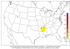
SPC's 4-8 is about as ominous as it can be without actually delineating an area.
I guess we can consider ourselves lucky that this pattern is occurring now rather than in April/May. What would 12/10-11 and 12/15 have been like with the sun angles and moisture depth of those months, all else being equal?
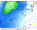
...DISCUSSION...
Above-average agreement persists with a shortwave trough near the
Pacific Northwest coast at 12Z Thu progressing east across the
northern states through D5/Fri. Cyclogenesis is expected over the
north-central states with poleward advection of modified moisture
from the western Gulf towards the OH Valley/Midwest in an air mass
characterized by well above-normal to potentially record warmth.
This might yield some severe potential on D5/Fri. However, with
further reinforcement of a continental polar air mass over the Gulf
through D2, the degree of moisture return in D4-5 may remain
insufficient to warrant a greater severe threat. It will prime the
moist sector for the next upstream trough, with some indications
that one at a lower latitude may evolve in the D8/Mon-D9/Tue time
frame. Spread in this scenario remains much too large to warrant
consideration of a severe weather area, but an above-average
warm/moist sector in terms of quality and spatial extent for late
December bears watching early next week.
I guess we can consider ourselves lucky that this pattern is occurring now rather than in April/May. What would 12/10-11 and 12/15 have been like with the sun angles and moisture depth of those months, all else being equal?
tennessee storm chaser
Member
- Messages
- 1,877
- Reaction score
- 4,283
- Location
- jackson tennessee
- Special Affiliations
- SKYWARN® Volunteer
Already talking deep moisture return not problem …SPC's 4-8 is about as ominous as it can be without actually delineating an area.
I guess we can consider ourselves lucky that this pattern is occurring now rather than in April/May. What would 12/10-11 and 12/15 have been like with the sun angles and moisture depth of those months, all else being equal?
I noticed that myself. Very intriguing.
- Moderator
- #1,317
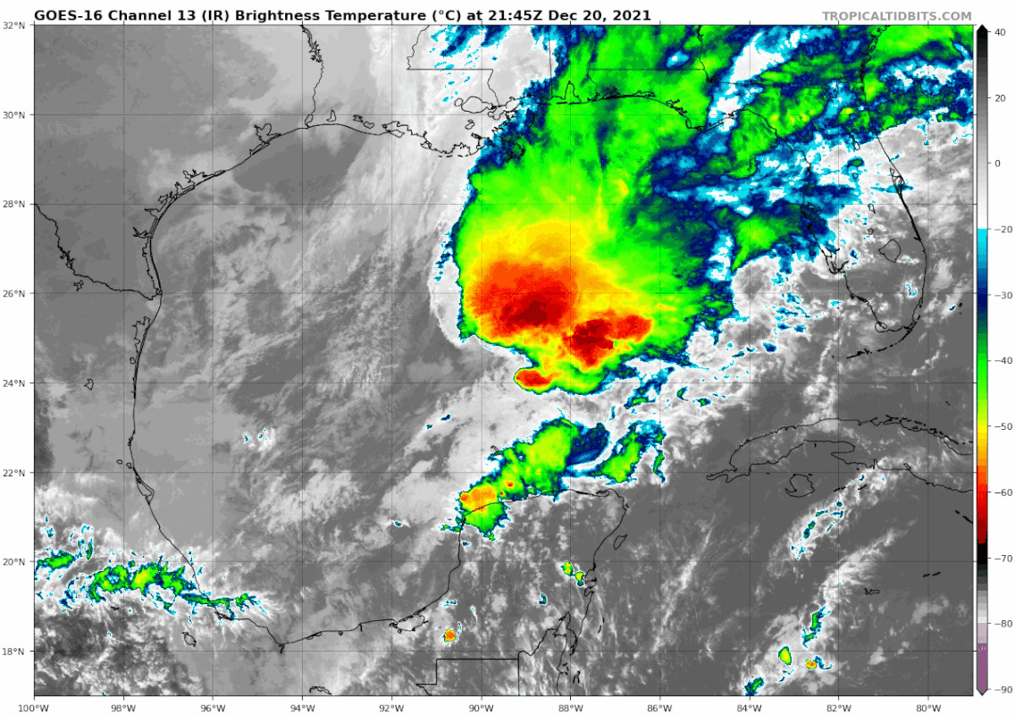
A strong system moving across the Gulf of Mexico will bring severe weather to Florida tomorrow.
Casuarina Head
Member
Well, 10–11 December was very close to some major springtime events in terms of intensity, as were 19–20 February ’84 (Enigma) and 5–6 February ’08 (Super Tuesday).SPC's 4-8 is about as ominous as it can be without actually delineating an area.
I guess we can consider ourselves lucky that this pattern is occurring now rather than in April/May. What would 12/10-11 and 12/15 have been like with the sun angles and moisture depth of those months, all else being equal?
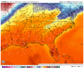
The west-based -NAO that is projected to be in place during the upcoming week might limit the spatial extent of any event that does occur, however, though it should serve to keep heights suppressed and maintain a low-amplitude flow over the warm sector. One could see multiple rounds of severe weather over portions of the southern Plains during the same timeframe, especially portions of North TX and southern OK. After all, the Garland TX EF4 (2015) occurred around Christmastime.
- Moderator
- #1,319
An early morning tornado injured one in south Fort Myers, FL and a wind driven coconut damaged a car in Miami.
An early morning tornado injured one in south Fort Myers, FL and a wind driven coconut damaged a car in Miami.
As a Floridian, I’m thinking of changing my user name to Wind Driven Coconut.
Sent from my iPhone using Tapatalk