Navigation
Install the app
How to install the app on iOS
Follow along with the video below to see how to install our site as a web app on your home screen.
Note: This feature may not be available in some browsers.
More options
-
Welcome to TalkWeather! We see you lurking around TalkWeather! Take the extra step and join us today to view attachments, see less ads and maybe even join the discussion. CLICK TO JOIN TALKWEATHER
You are using an out of date browser. It may not display this or other websites correctly.
You should upgrade or use an alternative browser.
You should upgrade or use an alternative browser.
Severe Weather 2021
- Thread starter Fred Gossage
- Start date
-
- Tags
- severe weather

Bama Ravens
Member
I just started a thread sharing an article about recent internet and data system issues at the NWS, including NWS Chat. The article is really worth a read.They seem to be having a lot of issues as of late. I know that during the last severe event the NWSChat service was randomly dropping out as well.
MattW
Member
- Messages
- 388
- Reaction score
- 382
- Location
- Decatur, GA
- HAM Callsign
- KG4GUF
- Special Affiliations
- SKYWARN® Volunteer
The 3km NAM seems more impressed for Georgia tomorrow than the HRRR.

sak
Member
Not sure where to post this, so figured I'd ask here.
Whenever I watch live coverage of tornado outbreaks on local stations, I always love the radar products they use. Is there any place I can go and do this myself during an outbreak? Where I can have windows open and quickly look at TDS information, put on a storm track and get arrival times, zoom in and out to see road level details of where the debris balls are, etc? James Spann and others do a great job but I'd love to be able to do the same in real-time at my battle station.
I would be curious what the price of such software would be for personal use.
Equus
Member
Not sure where to post this, so figured I'd ask here.
Whenever I watch live coverage of tornado outbreaks on local stations, I always love the radar products they use. Is there any place I can go and do this myself during an outbreak? Where I can have windows open and quickly look at TDS information, put on a storm track and get arrival times, zoom in and out to see road level details of where the debris balls are, etc? James Spann and others do a great job but I'd love to be able to do the same in real-time at my battle station.
I would be curious what the price of such software would be for personal use.
I'd imagine much of the station software and products are media proprietary (will let the station mets here chime in) but Gibson Ridge products are probably the best for that level of detail and flexibility; I personally haven't yet saved up to invest in them but it's about the best thing easily available for that level of usability, ranging from $79 to $250 http://www.grlevelx.com/
Radarscope app doesn't have individual streets but does have storm tracks, towns, and multi panel display with numerous radar products available, it's very affordable and what I've used thus far; desktop version runs $30 ($10 annual subscription for the best features) and mobile version is just the $10 annual subscription I think
Kolle
Member
As Eqqus said, Gibson Ridge software is your best bet. I use GRLevel 3 and it is infinitely customizable. I have added custom color tables and regional road maps to my version. Better yet, it comes with a free 3-week trial. I would wait until we have another severe weather event (it cannot be long off) and try it then. The cost after the trial is $80.Not sure where to post this, so figured I'd ask here.
Whenever I watch live coverage of tornado outbreaks on local stations, I always love the radar products they use. Is there any place I can go and do this myself during an outbreak? Where I can have windows open and quickly look at TDS information, put on a storm track and get arrival times, zoom in and out to see road level details of where the debris balls are, etc? James Spann and others do a great job but I'd love to be able to do the same in real-time at my battle station.
I would be curious what the price of such software would be for personal use.
It does not have a storm tracker.

CheeselandSkies
Member
Not that it means anything this far out, but CIPS is picking up on the system for the middle part of next week.
View attachment 8096
Several runs of the GFS have been fairly consistent with a surface and 500mb pattern that would be more of a threat to the Plains on Tuesday and the upper Midwest on Wednesday. Of course the details are nebulous and there are lots of moving parts at this range, but there's clearly some potential there for "something somewhere" which is about all that can be said with confidence at this point.
tennessee storm chaser
Member
- Messages
- 1,876
- Reaction score
- 4,283
- Location
- jackson tennessee
- Special Affiliations
- SKYWARN® Volunteer
Upper part of the south needs pay attention on it also for towards end next week ...Several runs of the GFS have been fairly consistent with a surface and 500mb pattern that would be more of a threat to the Plains on Tuesday and the upper Midwest on Wednesday. Of course the details are nebulous and there are lots of moving parts at this range, but there's clearly some potential there for "something somewhere" which is about all that can be said with confidence at this point.
Brice Wood
Member
I hate where that isNot that it means anything this far out, but CIPS is picking up on the system for the middle part of next week.
View attachment 8096
I'd imagine much of the station software and products are media proprietary (will let the station mets here chime in) but Gibson Ridge products are probably the best for that level of detail and flexibility; I personally haven't yet saved up to invest in them but it's about the best thing easily available for that level of usability, ranging from $79 to $250 http://www.grlevelx.com/
Radarscope app doesn't have individual streets but does have storm tracks, towns, and multi panel display with numerous radar products available, it's very affordable and what I've used thus far; desktop version runs $30 ($10 annual subscription for the best features) and mobile version is just the $10 annual subscription I think
Personally, I use GRLevel2 Analyst's Edition when tracking severe weather. I've found it to be quite useful in quickly analyzing various aspects of severe weather (e.g. areas of tight rotation indicative of mesocyclones and tornado vortex signatures). The price may be a bit on the high side (around $250 IIRC), but if you like using it often enough and are willing to spend the time to learn how to use its various features, that price just might end up being a bargain (as was the case for me)!
")
Not that it means anything this far out, but CIPS is picking up on the system for the middle part of next week.
View attachment 8096
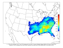
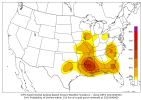
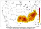
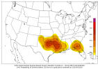
First off, those probabilities make it look like a textbook Dixie Alley setup. Second, I can't help but wonder if it has any breakdown on the probabilities (tornado/wind/hail), i.e. is it (verbatim) a primarily single-hazard setup or are multiple hazards (perhaps even all of them) on the table?
(EDIT: Took a look on the main website. The probabilities verbatim are wind/hail-driven, with less than 2% probabilities across the board for tornadoes.)
Last edited:
Equus
Member
I'll eventually make the dive and invest in it just have to find a time that's safe to do so lol. Does that have support for historical radar imagery? Would be totally worth the cost to be able to analyze past events during slow timesPersonally, I use GRLevel2 Analyst's Edition when tracking severe weather. I've found it to be quite useful in quickly analyzing various aspects of severe weather (e.g. areas of tight rotation indicative of mesocyclones and tornado vortex signatures). The price may be a bit on the high side (around $250 IIRC), but if you like using it often enough and are willing to spend the time to learn how to use its various features, that price just might end up being a bargain (as was the case for me)!
First off, those probabilities make it look like a textbook Dixie Alley setup. Second, I can't help but wonder if it has any breakdown on the probabilities (tornado/wind/hail), i.e. is it (verbatim) a primarily single-hazard setup or are multiple hazards (perhaps even all of them) on the table?
I'll eventually make the dive and invest in it just have to find a time that's safe to do so lol. Does that have support for historical radar imagery? Would be totally worth the cost to be able to analyze past events during slow times
It does have support, but you'll need to download it. The files have been made open access (though I forget offhand the URL for the database); alternately, the NCEI has (or at least used to have, it's been a while since I visited so I don't know its current status) a page where you could also select radar files from a particular radar and a particular timeframe (assuming said data actually was saved to the NCEI database), and then give them your email address and they'll email the requested files after a few minutes or so.
Once you have the selected radar files, all you have to do is drag and drop the files (or at least a certain number; you can only load in so many volume scans, a number that probably depends on the amount of data per scan, though I don't know the actual limit) into an open GRLevelX window (though be sure you have the right data: if the data is Level II, use GRLevel2; and if it's Level III, use GRLevel3) and there you go.
(Also, if you plan on repeatedly referring back to that radar data from time to time, I'd recommend saving it in some kind of appropriately-labeled download file so that you can have access to it any time you like. I have the Level II data from the Mississippi and Alabama radars on 4/27/2011 saved to my computer, for example.)
Equus
Member
Sweet, thanks. Sounds easy enough. Definitely an investment I will make in the near future.It does have support, but you'll need to download it. The files have been made open access (though I forget offhand the URL for the database); alternately, the NCEI has (or at least used to have, it's been a while since I visited so I don't know its current status) a page where you could also select radar files from a particular radar and a particular timeframe (assuming said data actually was saved to the NCEI database), and then give them your email address and they'll email the requested files after a few minutes or so.
Once you have the selected radar files, all you have to do is drag and drop the files (or at least a certain number; you can only load in so many volume scans, a number that probably depends on the amount of data per scan, though I don't know the actual limit) into an open GRLevelX window (though be sure you have the right data: if the data is Level II, use GRLevel2; and if it's Level III, use GRLevel3) and there you go.
(Also, if you plan on repeatedly referring back to that radar data from time to time, I'd recommend saving it in some kind of appropriately-labeled download file so that you can have access to it any time you like. I have the Level II data from the Mississippi and Alabama radars on 4/27/2011 saved to my computer, for example.)
CheeselandSkies
Member
GFS has well over 3, 000 j/kg of SBCAPE over portions of LA/MS (and over 2,000 j/kg in much of AL and parts of TN/KY) next Thursday. It's been consistent with that general look for a few runs now. Wind fields look less than ideal for tornadoes at this point, but would be a potent wind/hail threat at the least.


Sweet, thanks. Sounds easy enough. Definitely an investment I will make in the near future.
I would also recommend checking out the owners forum for GRLevelX:
It's members-only, but it's fairly easy to make an account. You'll find quite a few useful resources there, including updates, places to submit bug reports and/or, feature requests, etc. I'm also a member there under this username (though I don't post there as often as I do here).
tennessee storm chaser
Member
- Messages
- 1,876
- Reaction score
- 4,283
- Location
- jackson tennessee
- Special Affiliations
- SKYWARN® Volunteer
Spc has a 5 days risk out for most Arkansas n parts west Tennessee... all severe modes appear be on table. Quick glance off some data I’m catching could be a bonafide serious damage wind threat for sure .
Last edited:
CIPS has a poor handling on the specific geographic location of everything, but it is progging the potential for widespread severe weather April 8-10. Attendant figures below.