• Welcome to TalkWeather!
    We see you lurking around TalkWeather! Take the extra step and join us today to view attachments, see less ads and maybe even join the discussion.
    CLICK TO JOIN TALKWEATHER
Logo 468x120

Archive Severe Weather 2019

Status
Not open for further replies.

warneagle

Member
Messages
3,729
Reaction score
3,208
Location
Arlington, VA
Special Affiliations
  1. SKYWARN® Volunteer
If this developing nor’easter plays out the way the models are showing, it might reach unprecedented low pressure levels for this time of year. The NAM gets it down to 969 over New England on Thursday morning and the GFS gets as low as 971 and the Euro as low as 972. Eric Fisher noted on twitter this morning that the record for October in Boston is 982.
 

Kory

Member
Messages
4,928
Reaction score
2,119
Location
Tuscaloosa, Alabama
There’s a lot of work the weekend system needs to do before it’s a substantial threat. I’m more intrigued by the possible tropical development in the Gulf to be honest.
 

Kory

Member
Messages
4,928
Reaction score
2,119
Location
Tuscaloosa, Alabama
Keep an eye on the system this weekend. BMX mentioning a non-zero chance of severe wx with a brief tornado or two. We have a game in Bryant Denny Stadium at 6pm on Saturday, which looks to be the peak time for some of these stronger storms to be working in. Throw in some PWATs that are 2.2-2.5" working into West/Central Alabama...we might have some flooding issues on gameday. Quite unusual...
 

andyhb

Member
Messages
1,034
Reaction score
2,691
Location
Norman, OK
A bit further down the road, but the non-GFS guidance has been suggesting the potential for a more substantial threat towards the middle of next week with copious amounts of moisture available. The 00z Euro had upper 60s dewpoints into central IL and IN on Wednesday and mid 70s dewpoints over AL and MS.
 

Taylor Campbell

Moderator
Moderator
PerryW Project Supporter
Messages
2,102
Reaction score
2,189
Location
Wedowee, AL
Special Affiliations
  1. SKYWARN® Volunteer
A bit further down the road, but the non-GFS guidance has been suggesting the potential for a more substantial threat towards the middle of next week with copious amounts of moisture available. The 00z Euro had upper 60s dewpoints into central IL and IN on Wednesday and mid 70s dewpoints over AL and MS.

That's just crazy!

2111
 

Taylor Campbell

Moderator
Moderator
PerryW Project Supporter
Messages
2,102
Reaction score
2,189
Location
Wedowee, AL
Special Affiliations
  1. SKYWARN® Volunteer
000
FXUS64 KBMX 231939
AFDBMX

Area Forecast Discussion
National Weather Service Birmingham AL
239 PM CDT Wed Oct 23 2019

.SHORT TERM...
/Updated at 0235 PM CDT Wed Oct 23 2019/

Sunday through Tuesday.

Model spread increases regarding the synoptic pattern evolution for
the remainder of the forecast period. The GFS develops a deep trough
over the eastern CONUS with a reinforcing shot of cooler air.
Meanwhile the ECMWF/Canadian indicate a positively tilted trough
over the western CONUS with subtropical ridging centered over the
Bahamas. This solution is supported by the European ensemble mean
and WPC`s preference. Will lean towards this solution. Therefore,
the cold front is expected to stall across the southeast counties
Sunday as it becomes parallel to the upper flow, before lifting
back to the north early next week. This will result in relatively
warm/humid and unsettled conditions, ahead of the next potential
system towards the middle of next week.

32/Davis
 

Taylor Campbell

Moderator
Moderator
PerryW Project Supporter
Messages
2,102
Reaction score
2,189
Location
Wedowee, AL
Special Affiliations
  1. SKYWARN® Volunteer
ZCZC SPCSWOD48 ALL
ACUS48 KWNS 230841
SPC AC 230841

Day 4-8 Convective Outlook
NWS Storm Prediction Center Norman OK
0341 AM CDT Wed Oct 23 2019

Valid 261200Z - 311200Z

...DISCUSSION...
Medium-range models continue to struggle with large-scale pattern
developments in the extended range, including the evolution of
blocking mid-level ridging over the eastern/northeastern Pacific,
and its influence on the downstream westerlies. Spread within and
among the model output is quite large concerning the short wave
developments within the westerlies through the period. This could
include a continuing series of short wave perturbations splitting
off the main belt of westerlies, east of the ridging, and digging
through the Intermountain West/Rockies, before accelerating
eastward.

Guidance largely continues to indicate that strong surface
cyclogenesis to the lee of the southern Rockies, which could
potentially provide support for an organized severe weather risk, is
unlikely during this period. However, the latest (23/00Z)
deterministic run of the ECMWF does offer one pattern evolution
which could be accompanied considerable severe weather potential,
from the southern Plains across and east of the middle/lower
Mississippi Valley during the early to middle portion of next week.
At this point, this seems an outlier, but trends will need to
continue to be monitored.
 

Taylor Campbell

Moderator
Moderator
PerryW Project Supporter
Messages
2,102
Reaction score
2,189
Location
Wedowee, AL
Special Affiliations
  1. SKYWARN® Volunteer
The GFS is making trends towards improving the severe potential next week.
 

Taylor Campbell

Moderator
Moderator
PerryW Project Supporter
Messages
2,102
Reaction score
2,189
Location
Wedowee, AL
Special Affiliations
  1. SKYWARN® Volunteer
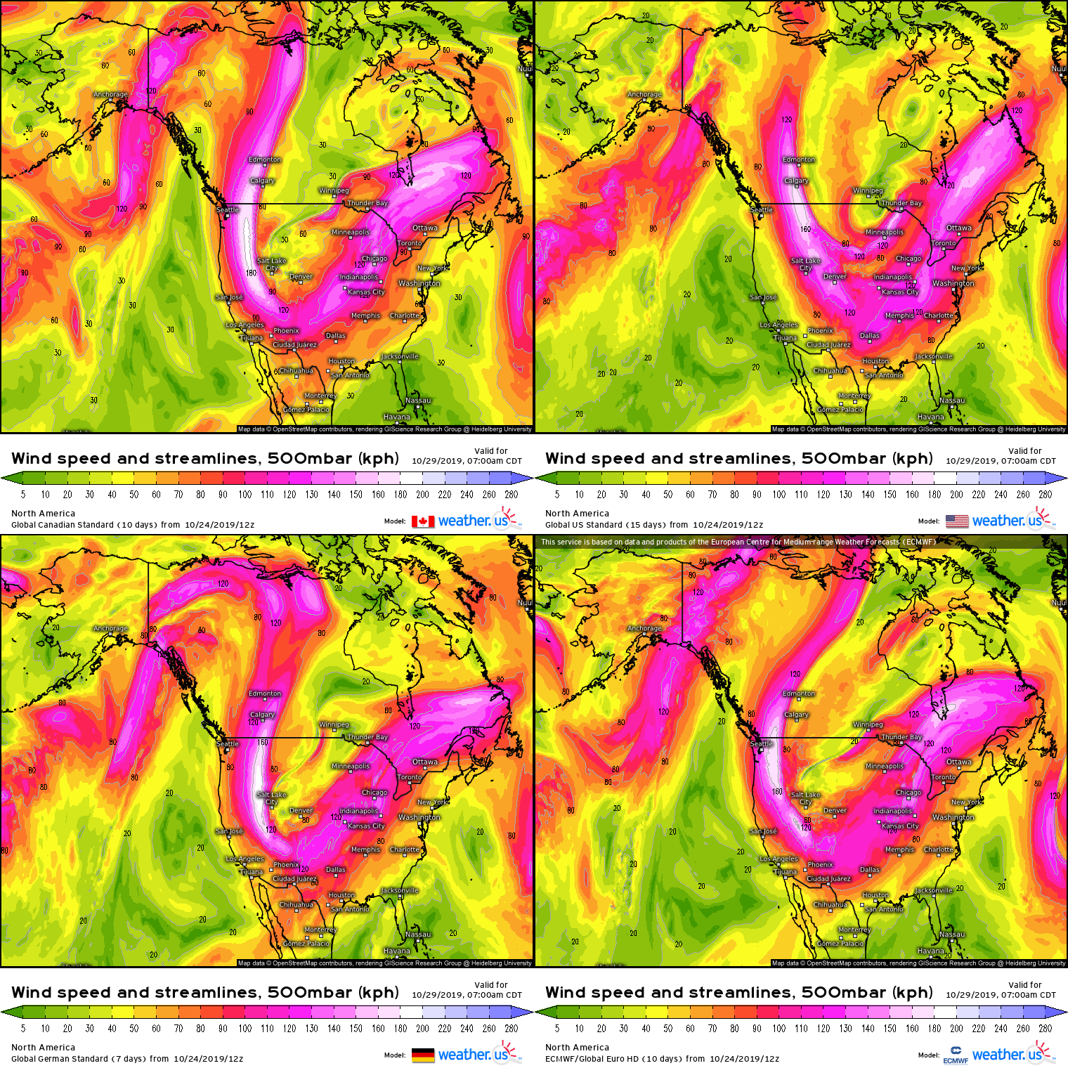
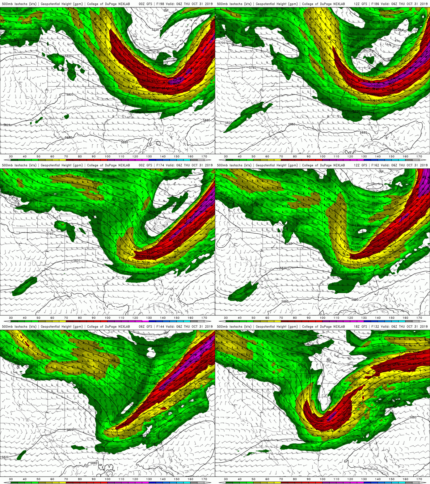
Take a look at the GFS trends.

12z model output comparison yesterday

output-Xq-Xc-O1.gif


Most recent model output comparison today

output-f64av-K.gif


Last 11 GFS runs

NEXLABdpdt-06-Z-20191031-GFSUS-500-spd-150-150.gif
 
  • Wow
Reactions: KoD

Taylor Campbell

Moderator
Moderator
PerryW Project Supporter
Messages
2,102
Reaction score
2,189
Location
Wedowee, AL
Special Affiliations
  1. SKYWARN® Volunteer
Again, there was another operational GFS run tonight that enhanced the severe threat for mid week next week. In addition, a significant uptick in ensemble support to go with it.
 
Messages
2,753
Reaction score
4,291
Location
Madison, WI
Again, there was another operational GFS run tonight that enhanced the severe threat for mid week next week. In addition, a significant uptick in ensemble support to go with it.

SPC still a bit uncertain, sticking with "predictability too low." They do note the potential in the text, though.

Just looking at the 500mb pattern on the 0Z GFS it looks quite dangerous for parts of the South around 18Z Thursday, but the composites and forecast soundings aren't too alarming at the moment, with mostly unidirectional winds. However those are details that have yet to be fully resolved at this range.
 
Last edited:

Kory

Member
Messages
4,928
Reaction score
2,119
Location
Tuscaloosa, Alabama
I'm not overly impressed with the latest trough evolution of this week's system. Big surge of tropical moisture will provide another shot at widespread heavy rainfall.
 
Status
Not open for further replies.
Back
Top