
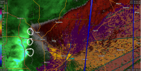
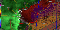
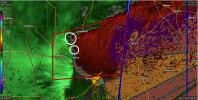
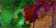
Pretty sure we had brief spin up somewhere along that line. I counted 3 circulations as that line was passing through before it reached me. As @Clancy mentioned, the one near Bigbee spun up and literally passed right over my house. One of them passed between Smithville and Hatley.
Navigation
Install the app
How to install the app on iOS
Follow along with the video below to see how to install our site as a web app on your home screen.
Note: This feature may not be available in some browsers.
More options
-
Welcome to TalkWeather! We see you lurking around TalkWeather! Take the extra step and join us today to view attachments, see less ads and maybe even join the discussion. CLICK TO JOIN TALKWEATHER
You are using an out of date browser. It may not display this or other websites correctly.
You should upgrade or use an alternative browser.
You should upgrade or use an alternative browser.
Severe WX Severe threat 3/30-3/31
- Thread starter Bulkshear
- Start date

Three rotation areas circled in white and little yellow symbol is my house. Tornado Warning gets issued. Top rotation signature weakens just west of me in 3rd while new rotation area develops north of Amory. In last image, 4 rotation signatures along the line with the weakening one passing over me. Top down look. By this time, the bottom 3 rotation signatures are east of Hatley
Attachments
Equus
Member
Got a tornado warned pre-QLCS supercell at least briefly down around Columbia, MS
UpperLevelLOL
Member
Whoa man this is a mean QLCS to wake up to. Lotta school districts in a tough place as to whether to roll out the school buses in this.

warneagle
Member
Looks like most of our area got trimmed out of the ENH area this morning
Equus
Member
BMX just going with a special weather statement for Walker looks like, will certainty take that trend but that bow apex still doesn't look ideal
Occluded basically as soon as they upgraded to a PDS, and the warning has been cancelled entirely.PDS for Hattiesburg.

Bama Ravens
Member
I’m sort of surprised that BMX hasn’t issued severe thunderstorm warnings for Winston and Walker Counties (Alabama).
CheeselandSkies
Member
Max tornado probability for today was dropped to 5% on the initial Day 1 outlook after being 10% on both Day 2 outlooks yesterday.
Bama Ravens
Member
Looks like the intensity of the portion of the line moving through west Alabama is trending down right now. That’s good news, hopefully that trend continues.
Equus
Member
Apex of the bow now passed, only gusting to 30-40 here; there are still some spicy segments here and there but for the most part has dropped to sub severe
Equus
Member
Honestly to me it seems SPC has become a bit averse to issuing a moderate risk for just wind unless tornado risk is also at moderate level lately; I'd wager if tornado had gone 15 hatch they would have hatched it
wx_guy
Member
- Messages
- 1,237
- Reaction score
- 4,443
- Location
- United States
- HAM Callsign
- KO4ZGH
- Special Affiliations
- SKYWARN® Volunteer
- ARRL Member
Looks like my model has done a good job predicting this bowing segment and wind threat (and lack of overall tornado threat) through Alabama so far. If it's still correct moving forward, the daytime heating will re-intensify this line as it moves through S AL and S GA.
I'm about to go get some shut eye. I've been up since roughly 8am yesterday morning.
Justin Hindman
Member
- Messages
- 378
- Reaction score
- 1,165
- Location
- Gardendale Alabama
- Special Affiliations
- SKYWARN® Volunteer
- ARRL Member
Just came through Birmingham, Winds gusted 10 maybe 15 mph, actually had some pea size hail. Not bad at all