pritchlaw
Member
Whole bunch of nothing in Blount County, AL but the kids got a day out of school, so there's that.
Follow along with the video below to see how to install our site as a web app on your home screen.
Note: This feature may not be available in some browsers.
Yeah, it was always the cause that the winds in N and N Central AL were gonna be in pockets. So the fact that you got nothing is not very surprising. They still did the right move to cancel because high winds can mess up school buses.Whole bunch of nothing in Blount County, AL but the kids got a day out of school, so there's that.


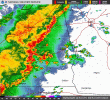
Yeah, and with daytime heating, the MCS will probably rev up some more.Pretty potent MCS here. Working with decent (1000 j/kg) instability, so might see some further intensification as it treks eastward. Shear is strongest across northern Georgia, and a small pocket of SRH at the low levels is located in east-central Alabama, so tornado risk is low but not zero, especially in that part of the line.
View attachment 37969View attachment 37970View attachment 37971View attachment 37972
So far, I am not impressed lolThings ramping up on this QLCS as it moves into western GA. Lots of bowing segments and transient mesos.
Yep. Newnan-LaGrange seems to be a hotspot for as long as I can remember.
