Kds86z
Member
I’ll say it….
Are we all just ignoring the latest D2 then? Oh ok lol

Follow along with the video below to see how to install our site as a web app on your home screen.
Note: This feature may not be available in some browsers.
I’ll say it….
Are we all just ignoring the latest D2 then? Oh ok lol
It looks a little limp.I’ll say it….
Are we all just ignoring the latest D2 then? Oh ok lol

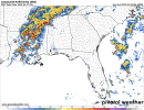
I definitely don't like that look on the storm it has moving through Monroe County, MS.Yeah... I don't like how this 00z HRRR run looks. (Storms grow upscale quick though at least)
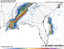
Interest may have, but the threat hasn't. Still some serious high-end localized potential from this event, and sadly a good chunk will happen at night.lol just judging by the speed of new pages on this thread, interest in this event has CRATERED haha
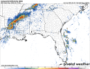
Not again…Trends have made Lousianna and South Mississippi a area to really watch Sunday night into Monday morning


lol just judging by the speed of new pages on this thread, interest in this event has CRATERED haha


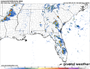
Yes, I’ve noticed a lot of talk about Alabama. I would love some insight on southern Indiana.The thread for the back-to-back MDT days May 25-26 last year was only at like 18-20 pages at this point on the 24th. Didn't pop until the events started. A lot of it has to do with what areas are affected. Seems like there's a lot of Dixie Alley, particularly Alabama guys here, so I noticed risks that center more around Dixie get more pages pre-outbreak. Nothing wrong with that at all though, as everyone focuses more on things that affect their area.
")