• Welcome to TalkWeather!
    We see you lurking around TalkWeather! Take the extra step and join us today to view attachments, see less ads and maybe even join the discussion.
    CLICK TO JOIN TALKWEATHER
Logo 468x120

Severe WX Severe Threat 27-28 March 2021

WhirlingWx

Member
Messages
323
Reaction score
320
Location
Northern DFW Metroplex
Unsurprisingly, the HRRR is the most aggressive of the CAMs for tomorrow wrt firing off discrete cells, but overall, the environment ain't too shabby (while obviously not in the same ballpark as yesterday's environment). Hoping this doesn't sneak up on people given how focus everyone has/had been on yesterday's threat.
 

Attachments

  • HRRR_3-26-21_12z.jpg
    HRRR_3-26-21_12z.jpg
    347.5 KB · Views: 0
  • HRRR_3-26-21_12z.2.jpg
    HRRR_3-26-21_12z.2.jpg
    348.8 KB · Views: 0

Fred Gossage

Member
Meteorologist
PerryW Project Supporter
Messages
596
Reaction score
2,095
Location
Florence, AL
When you guys look at this going forward, keep in mind the fact that when your mid/upper winds are as veered WSW or W as this situation will be, it's a good deal easier to get away with SSW sfc winds to have a few tornadoes. Dixie Alley into the Ohio Valley has way more tornado days with SSW sfc winds than a lot of people realize. I don't think this is in the same league as anything we've seen the past 14 days, but I highly doubt we get by this without tornado warnings and maybe some damage in a few spots. This is just a year when, even when the overall scope of an event may underperform on the whole, individual storms within that overperform. This year is different, and that has been proven multiple times now, going back to Fultondale... and it speaks a lot to the environmental background conditions in place that we've talked about on this forum for the past several months.
 

MattPetrulli

Member
Messages
420
Reaction score
466
Location
Pigeon Forge, TN
Day 2 has gone hatched
...THERE IS AN ENHANCED RISK OF SEVERE THUNDERSTORMS OVER A PORTION
OF THE LOWER MISSISSIPPI INTO THE TENNESSEE VALLEY REGIONS...

..SUMMARY


SEVERE STORMS ARE POSSIBLE SATURDAY ACROSS THE LOWER MISSISSIPPI
THROUGH TENNESSEE VALLEY REGIONS. ALL HAZARDS ARE POSSIBLE INCLUDING
LARGE HAIL, DAMAGING WIND, AND TORNADOES. POTENTIAL FOR A STRONG
TORNADO EXISTS FROM EASTERN ARKANSAS INTO WESTERN TENNESSEE. OTHER
SEVERE STORMS ARE POSSIBLE ACROSS A PORTION OF THE MIDWEST WITH
ISOLATED DAMAGING WIND AND LARGE HAIL THE MAIN THREATS.

..SYNOPSIS


AT UPPER LEVELS, A SOUTHERN STREAM SHORTWAVE TROUGH WILL MOVE
THROUGH THE SOUTHERN HIGH PLAINS INTO CENTRAL TEXAS. A NORTHERN
STREAM SHORTWAVE TROUGH WILL AMPLIFY ACROSS THE UPPER MIDWEST. THESE
FEATURES WILL EVENTUALLY PHASE LATE IN THE PERIOD NEAR THE
MISSISSIPPI VALLEY. AT THE SURFACE, A WARM FRONT IN THE SOUTHEAST
WILL ADVANCE NORTHWARD BEFORE SLOWING/STALLING IN THE VICINITY OF
THE TENNESSEE VALLEY. A SURFACE CYCLONE WILL DEEPEN ACROSS ILLINOIS
AND WISCONSIN AND BRING A COLD FRONT THROUGH THE UPPER MIDWEST
SOUTHWARD INTO THE LOWER MISSISSIPPI VALLEY.

..LOWER MISSISSIPPI THROUGH TENNESSEE VALLEYS


MOISTURE RETURN WILL BE ONGOING AT THE START OF THE PERIOD AND
THROUGH THE DAY. WITH UPPER 60S TO LOW 70S F DEWPOINT CURRENTLY
ALONG THE GULF COAST, IT SEEMS PROBABLE THAT MID TO UPPER 60S
DEWPOINTS WILL EXIST IN THE WARM SECTOR. GIVEN POTENTIAL FOR
ELEVATED THUNDERSTORMS TO DEVELOP ALONG THE NORTHWARD ADVANCING WARM
FRONT, THERE IS SOME UNCERTAINTY AS TO HOW FAR NORTH THE EFFECTIVE
BOUNDARY WILL BE. EVEN SO, SURFACE HEATING SHOULD SUPPORT
BOUNDARY-LAYER DESTABILIZATION WITH 1500-2000 J/KG MLCAPE BY THE
AFTERNOON. EFFECTIVE SHEAR WILL BE STRONG AT 50-65 KTS. ORGANIZED
STORMS WILL BE CAPABLE OF ALL SEVERE HAZARDS. THE GREATEST POTENTIAL
FOR TORNADOES AND LARGER HAIL WILL EXIST WITH STORMS THAT DEVELOP ON
THE SLOWING WARM FRONT WHERE MORE CELLULAR DEVELOPMENT WOULD BE
POSSIBLE. LATER IN THE EVENING, THE COLD FRONT WILL MOVE THROUGH THE
REGION AND DAMAGING WIND GUSTS WILL BECOME THE PRIMARY THREAT,
THOUGH QLCS CIRCULATIONS WILL ALSO BE POSSIBLE GIVEN ADEQUATE
LOW-LEVEL SHEAR PROFILES.
1616779745604.png
 

FEARLESS

Member
Messages
37
Reaction score
3
Location
Signal Mountain, TN
Special Affiliations
  1. SKYWARN® Volunteer
Day 2 has gone hatched
...THERE IS AN ENHANCED RISK OF SEVERE THUNDERSTORMS OVER A PORTION
OF THE LOWER MISSISSIPPI INTO THE TENNESSEE VALLEY REGIONS...

..SUMMARY


SEVERE STORMS ARE POSSIBLE SATURDAY ACROSS THE LOWER MISSISSIPPI
THROUGH TENNESSEE VALLEY REGIONS. ALL HAZARDS ARE POSSIBLE INCLUDING
LARGE HAIL, DAMAGING WIND, AND TORNADOES. POTENTIAL FOR A STRONG
TORNADO EXISTS FROM EASTERN ARKANSAS INTO WESTERN TENNESSEE. OTHER
SEVERE STORMS ARE POSSIBLE ACROSS A PORTION OF THE MIDWEST WITH
ISOLATED DAMAGING WIND AND LARGE HAIL THE MAIN THREATS.

..SYNOPSIS


AT UPPER LEVELS, A SOUTHERN STREAM SHORTWAVE TROUGH WILL MOVE
THROUGH THE SOUTHERN HIGH PLAINS INTO CENTRAL TEXAS. A NORTHERN
STREAM SHORTWAVE TROUGH WILL AMPLIFY ACROSS THE UPPER MIDWEST. THESE
FEATURES WILL EVENTUALLY PHASE LATE IN THE PERIOD NEAR THE
MISSISSIPPI VALLEY. AT THE SURFACE, A WARM FRONT IN THE SOUTHEAST
WILL ADVANCE NORTHWARD BEFORE SLOWING/STALLING IN THE VICINITY OF
THE TENNESSEE VALLEY. A SURFACE CYCLONE WILL DEEPEN ACROSS ILLINOIS
AND WISCONSIN AND BRING A COLD FRONT THROUGH THE UPPER MIDWEST
SOUTHWARD INTO THE LOWER MISSISSIPPI VALLEY.

..LOWER MISSISSIPPI THROUGH TENNESSEE VALLEYS


MOISTURE RETURN WILL BE ONGOING AT THE START OF THE PERIOD AND
THROUGH THE DAY. WITH UPPER 60S TO LOW 70S F DEWPOINT CURRENTLY
ALONG THE GULF COAST, IT SEEMS PROBABLE THAT MID TO UPPER 60S
DEWPOINTS WILL EXIST IN THE WARM SECTOR. GIVEN POTENTIAL FOR
ELEVATED THUNDERSTORMS TO DEVELOP ALONG THE NORTHWARD ADVANCING WARM
FRONT, THERE IS SOME UNCERTAINTY AS TO HOW FAR NORTH THE EFFECTIVE
BOUNDARY WILL BE. EVEN SO, SURFACE HEATING SHOULD SUPPORT
BOUNDARY-LAYER DESTABILIZATION WITH 1500-2000 J/KG MLCAPE BY THE
AFTERNOON. EFFECTIVE SHEAR WILL BE STRONG AT 50-65 KTS. ORGANIZED
STORMS WILL BE CAPABLE OF ALL SEVERE HAZARDS. THE GREATEST POTENTIAL
FOR TORNADOES AND LARGER HAIL WILL EXIST WITH STORMS THAT DEVELOP ON
THE SLOWING WARM FRONT WHERE MORE CELLULAR DEVELOPMENT WOULD BE
POSSIBLE. LATER IN THE EVENING, THE COLD FRONT WILL MOVE THROUGH THE
REGION AND DAMAGING WIND GUSTS WILL BECOME THE PRIMARY THREAT,
THOUGH QLCS CIRCULATIONS WILL ALSO BE POSSIBLE GIVEN ADEQUATE
LOW-LEVEL SHEAR PROFILES.
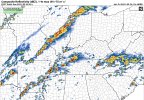
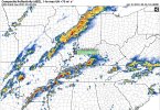
View attachment 7707
Here we go again. Yesterday in chattanooga we had minimal damage but alot of flooding.
 

Equus

Member
Messages
3,290
Reaction score
3,368
Location
Jasper, AL
Special Affiliations
  1. SKYWARN® Volunteer
Decent odds on SREF, could be a surprise or two

SREF_prob_sigtor_5__f033.gif
 

Timhsv

Member
Messages
410
Reaction score
687
Location
Meridianville, AL.
Special Affiliations
  1. SKYWARN® Volunteer
When you guys look at this going forward, keep in mind the fact that when your mid/upper winds are as veered WSW or W as this situation will be, it's a good deal easier to get away with SSW sfc winds to have a few tornadoes. Dixie Alley into the Ohio Valley has way more tornado days with SSW sfc winds than a lot of people realize. I don't think this is in the same league as anything we've seen the past 14 days, but I highly doubt we get by this without tornado warnings and maybe some damage in a few spots. This is just a year when, even when the overall scope of an event may underperform on the whole, individual storms within that overperform. This year is different, and that has been proven multiple times now, going back to Fultondale... and it speaks a lot to the environmental background conditions in place that we've talked about on this forum for the past several months.
I think your dead on Fred. Case in point, last nights Newman, Ga. EF4. If I'm not badly mistaken, it was just in a SLIGHT RSK area, thou MCD 0268 covered the risk at that time.
 
Messages
1,030
Reaction score
1,218
Location
jackson tennessee
Special Affiliations
  1. SKYWARN® Volunteer
well reed trimmer is here around jackson tn area setting up along i40 for later this evening, see what happens... keeping eye back sw of me for discrete super cells later
 

Mike S

Administrator
Staff member
Administrator
Moderator
PerryW Project Supporter
Messages
1,991
Reaction score
1,115
Location
Meridianville, Al
Special Affiliations
  1. SKYWARN® Volunteer
Tornado Watch coming soon across southern Tennessee and northern Mississippi and Alabama

 
Messages
2,753
Reaction score
4,289
Location
Madison, WI
Haven't really looked too closely at this setup yet...was kind of surprised to pull up the SPC site with the national radar loop on the homepage and see a lack of widespread precipitation over most of the Enhanced Risk area (except middle Tennessee). What are the expected limiting factors that this is not a higher category already?
 

andyhb

Member
Messages
1,033
Reaction score
2,689
Location
Norman, OK
Haven't really looked too closely at this setup yet...was kind of surprised to pull up the SPC site with the national radar loop on the homepage and see a lack of widespread precipitation over most of the Enhanced Risk area (except middle Tennessee). What are the expected limiting factors that this is not a higher category already?
Storm mode amongst others. Storm motion today favors a long residence time near the boundary which may yield upscale growth (but is also favorable for stronger low level SRH).
 

WhirlingWx

Member
Messages
323
Reaction score
320
Location
Northern DFW Metroplex

80/60 TOR probabilities on this watch, with high wind probabilities and moderate-high hail probabilities as well.

URGENT - IMMEDIATE BROADCAST REQUESTED
Tornado Watch Number 59
NWS Storm Prediction Center Norman OK
145 PM CDT Sat Mar 27 2021

The NWS Storm Prediction Center has issued a

* Tornado Watch for portions of
Extreme northern Alabama
Extreme east central Arkansas
Northern Mississippi
Southern parts of western and middle Tennessee

* Effective this Saturday afternoon and evening from 145 PM until
900 PM CDT.

* Primary threats include...
Several tornadoes and a couple intense tornadoes likely
Scattered damaging winds and isolated significant gusts to 75
mph likely
Scattered large hail and isolated very large hail events to 3
inches in diameter likely

SUMMARY...Severe storm development is expected by mid afternoon and
storms will persist well into this evening. The storm environment
favors supercells capable of producing a couple of strong tornadoes
and very large hail near the size of baseballs. As storms cluster
more into the evening, the threat for damaging winds will increase,
including the potential for hurricane force gusts.
 

Mike S

Administrator
Staff member
Administrator
Moderator
PerryW Project Supporter
Messages
1,991
Reaction score
1,115
Location
Meridianville, Al
Special Affiliations
  1. SKYWARN® Volunteer
No one is paying attention today. Watch this be the day the Huntsville area gets a scare after the last 2 systems didn't produce anything here.
 

BWER47

Member
Messages
1
Reaction score
1
Location
Harvest, Alabama
HAM Callsign
AI4U
Special Affiliations
  1. SKYWARN® Volunteer
  2. ARRL Member
Mike,

Bite your tongue! But it does feel more like a severe day. Temp 80 dewpoint just hit 70. Winds out of SSW gusting at times. Don't know what the upper levels are doing. When things start to ramp up, it could be quick.
 

Tennie

Member
Messages
935
Reaction score
761
Location
Tennessee
TOR southwest of (of all places today) Raleigh, NC:

361
WFUS52 KRAH 272019
TORRAH
NCC105-123-125-272100-
/O.NEW.KRAH.TO.W.0011.210327T2019Z-210327T2100Z/

BULLETIN - EAS ACTIVATION REQUESTED
Tornado Warning
National Weather Service Raleigh NC
419 PM EDT Sat Mar 27 2021

The National Weather Service in Raleigh has issued a

* Tornado Warning for...
Northern Moore County in central North Carolina...
Northeastern Montgomery County in central North Carolina...
Southwestern Lee County in central North Carolina...

* Until 500 PM EDT.

* At 419 PM EDT, a severe thunderstorm capable of producing a tornado
was located over Biscoe, or 7 miles east of Troy, moving east at 30
mph.

HAZARD...Tornado and quarter size hail.

SOURCE...Radar indicated rotation.

IMPACT...Flying debris will be dangerous to those caught without
shelter. Mobile homes will be damaged or destroyed.
Damage to roofs, windows, and vehicles will occur. Tree
damage is likely.

* This dangerous storm will be near...
Carthage around 500 PM EDT.

Other locations impacted by this tornadic thunderstorm include Star,
Candor, Highfalls, Eagle Springs and Robbins.

PRECAUTIONARY/PREPAREDNESS ACTIONS...

TAKE COVER NOW! Move to a basement or an interior room on the lowest
floor of a sturdy building. Avoid windows. If you are outdoors, in a
mobile home, or in a vehicle, move to the closest substantial shelter
and protect yourself from flying debris.

&&

LAT...LON 3552 7947 3552 7936 3534 7917 3528 7982
3540 7987
TIME...MOT...LOC 2019Z 254DEG 25KT 3533 7976

TORNADO...RADAR INDICATED
HAIL...1.00IN

$$

23
 
Back
Top