Kory
Member
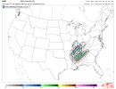
Looks like the SPC upgrades/expanded the slight risk into Eastern AR and NW MS. They’re indicating that a complex of severe storms (cellular and bowing segments) will develop along the warm front and lift NE overnight and early tomorrow morning. Will be interesting the trajectory and strength as the warm front lifts north. Does that keep tracking toward Northern MS/AL and into TN?