
Ehhh, I’m not so sure about that re: little time for recovery on that run. Morning precip on that generally moves out by 15-18z in AL.The 12z nam trends a little closer to euro and gfs with stronger low and little further south. Also, shows very little time between morning rain/leftover clouds and afternoon storms firing. Volatile environment, just not sure I completely believe it as morning rain is slow to leave with little clearing, in any.
Navigation
Install the app
How to install the app on iOS
Follow along with the video below to see how to install our site as a web app on your home screen.
Note: This feature may not be available in some browsers.
More options
-
Welcome to TalkWeather! We see you lurking around TalkWeather! Take the extra step and join us today to view attachments, see less ads and maybe even join the discussion. CLICK TO JOIN TALKWEATHER
You are using an out of date browser. It may not display this or other websites correctly.
You should upgrade or use an alternative browser.
You should upgrade or use an alternative browser.
Severe WX Severe Threat 25 March 2021
- Thread starter MattPetrulli
- Start date
-
- Tags
- severe wx
4k nam 12z, Noon Thu, doubt there is much sunshine at all, also some junk convection firing. While a cap may building in, convection fires too fast for it to make much difference.Ehhh, I’m not so sure about that re: little time for recovery on that run. Morning precip on that generally moves out by 15-18z in AL.

David in SW Blount
Member
So, if I'm reading that right. Seeing as I live outside Chattanooga in the valley...I shouldn't worry so much about living in a newer model manufactured home? The worst action will stay west and south?
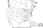
This graphic from the NWS office serving Chattanooga shows a Level 3 threat in that area, so you are certainly under the gun.

If north Alabama clears out with sun before afternoon storms, the threat will be further east and especially north than on current forecasts...but that is a big IF.
Kory
Member
Looks like most modeling is getting Central MS/AL into the mid 70s with near 70 dews. That is yielding about 2500-3000 J/KG SBCAPE. I think that temperature is very achievable without any sunshine. Any sun would get us close to 80 and a huge yikes.
Looks like most modeling is getting Central MS/AL into the mid 70s with near 70 dews. That is yielding about 2500-3000 J/KG SBCAPE. I think that temperature is very achievable without any sunshine. Any sun would get us close to 80 and a huge yikes.
That's almost my exact thoughts as well looking at things this morning. This is still modelled an upper end threat, with plenty of instability, with no clearing. If we get some additional sun tomorrow, well, like you said, huge yikes.
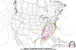
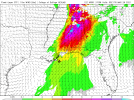
While the aforementioned concerns remain regarding junk convection and capping, here's a few graphics to show why everyone, including those in East/Northeast Alabama and Northwestern Georgia need to be on their toes tomorrow.
Attachments

One important difference compared to last week. Td's are less of a question. The day before models had the BHM td dropping during the morning as the pseudo wedge was flexing...no sign of that here. Yes, there will be instability even with clouds and rain leftover. A significant event is very possible.
absolutely, everyone needs to pay attention!
While the aforementioned concerns remain regarding junk convection and capping, here's a few graphics to show why everyone, including those in East/Northeast Alabama and Northwestern Georgia need to be on their toes tomorrow.
MattW
Member
- Messages
- 388
- Reaction score
- 382
- Location
- Decatur, GA
- HAM Callsign
- KG4GUF
- Special Affiliations
- SKYWARN® Volunteer
Can you post the link to these? I still can't find them on the CIPS site.While the aforementioned concerns remain regarding junk convection and capping, here's a few graphics to show why everyone, including those in East/Northeast Alabama and Northwestern Georgia need to be on their toes tomorrow.
Marshal79344
Member
Personally, I don't think the lower-level thermodynamics is going to be that much of an issue given the kinematics we have at play, regardless of cloud cover or not given the type of moisture return we have in place. Also, with the over convection scenario, I feel that the HRRR has the absolute worst-case scenario. The 850 level jet and the overall organization of the low isn't too strong to trigger massive amounts of convection which would result in upscale growth and mergers, but it's just right so that it would favor discrete supercells to form and have some breathing space to them. Other models are generally agreeing about the intensity of the 850 level jet across Dixie Alley, however, the NAM and HRRR are really catching onto that jet running much further north than anticipated, which would raise even more concerns if that were to verify. Based on model consensus at the moment, the speed shear and directional shear values are easily strong enough to get anything that forms and become well-established to have intense tornado potential. Consensus between the models has increased steadily towards a much more potent scenario than 3/17.
Marshal79344
Member
I could be wrong on some of this, as I've recently made an effort to increase my understanding of the upper level jet dynamics, kinematics, and thermodynamics, so I would really appreciate someone to correct me if I have got some of it wrong.Personally, I don't think the lower-level thermodynamics is going to be that much of an issue given the kinematics we have at play, regardless of cloud cover or not given the type of moisture return we have in place. Also, with the over convection scenario, I feel that the HRRR has the absolute worst-case scenario. The 850 level jet and the overall organization of the low isn't too strong to trigger massive amounts of convection which would result in upscale growth and mergers, but it's just right so that it would favor discrete supercells to form and have some breathing space to them. Other models are generally agreeing about the intensity of the 850 level jet across Dixie Alley, however, the NAM and HRRR are really catching onto that jet running much further north than anticipated, which would raise even more concerns if that were to verify. Based on model consensus at the moment, the speed shear and directional shear values are easily strong enough to get anything that forms and become well-established to have intense tornado potential. Consensus between the models has increased steadily towards a much more potent scenario than 3/17.
Oh, that's my bad! I edited in the link on my post yesterday but I should've figured it wouldn't have shown up. The first three are from CIPS but the last is from COD's products (https://weather.cod.edu/).Can you post the link to these? I still can't find them on the CIPS site.
Here it is: http://www.eas.slu.edu/CIPS/MODEL/WXmodel.php

maroonedinhsv
Member
I would like to remind everyone that when an event like this is looming, we have a lot of visitors and infrequent members reading the thread. These readers are not familiar with the personalities and desires of the posters, so when they read something like "This looks bad", it could be completely misinterpreted (Looking bad for fans of severe weather is very different than looking bad for people opposed to severe weather). "This looks dangerous" and "This looks like we won't have the ingredients necessary for long-track tornadoes" would be much better. We now return you to your regularly scheduled programming.
Kory
Member
One thing that will help drive the EML inland are stronger mid level winds at 700mb. Last week, those were kinda weak at the onset and the EML got stunted down south. This time, guidance over spreads a large portion of the SE.
KevinH
Member
There are 3 CIPS sites that I see people pull data from:Can you post the link to these? I still can't find them on the CIPS site.
1. http://www.eas.slu.edu/CIPS/SVRprob/SVRprob.php
2. http://www.eas.slu.edu/CIPS/ANALOG/analog.php
3. http://www.eas.slu.edu/CIPS/MODEL/WXmodel.php (This is one of the sites Clancy used to post some of his/her graphics.)
ChaninCullman
Member
When does the next data come in? Trying to decide if I’m going to my daughter’s’ basement in Tuscaloosa
- Admin
- #159
I took the symbol out. Always have a plan. If that is your safe place in Tuscaloosa, I would definitely have it ready.When does the next data come in? Trying to decide if I’m going to my daughter’s’ basement in Tuscaloosa
KevinH
Member
I would start driving just as a precaution. If you have a chance to take cover in a basement, even if it is a bit of a drive, I would take advantage. Better safe than sorry.When does the next data come in? Trying to decide if I’m going to my daughter’s’ basement in Tuscaloosa