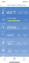
Equus
Member
Just eight days apart. Can tornado season hurry and end pls

Follow along with the video below to see how to install our site as a web app on your home screen.
Note: This feature may not be available in some browsers.
If this unfolds today the NWS offices need to use enhanced wording for the most dire tornado warnings and emergencies. Like the NWS in Wichita used on 4/14/12. https://www.alabamawx.com/?p=59262My goodness that's strong wording in the Outlook.
Sent from my SM-G975U1 using Tapatalk
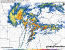
This is what I am watching. It seems like the HRRR wants to keep developing showers and storms for the next several hours though. This shows rain and clouds still socking in most of north Alabama at 11am (graphic shown), and even after that -- some scattered showers around. Doesn't really look like the sun is going to break out in full force across north/central AL for much time today according to the HRRR. But who knows...Looks like there’s already some breaks in the clouds down to the south-southwest of the rain. What are the chances the low-level stuff gets burnt off by mid morning?

A lot of convection across the region this morning. Could help us out later today if junk convection continues into the late morning
 . 08Z backed off a little bit but still quite rough-looking especially for TN and NW AL.
Do you have an image of the 07z ? Haven’t had a chance to look at recent modelsRadar looks mostly clear in the southern half of Alabama and most of MS with only scattered showers/storms. Not the sort of thing that generates an instability-killing cold pool.
07Z HRRR is
Snapshot valid for 23Z tonight:Do you have an image of the 07z ? Haven’t had a chance to look at recent models
 please y’all stay safe out there! this will for sure be more active and deadly than march 17
It could, if it were mid April, no question. Now we wait and see what happens in places like Jackson and Meridian Miss.Looks like there’s already some breaks in the clouds down to the south-southwest of the rain. What are the chances the low-level stuff gets burnt off by mid morning?
If current radar trends continue, I see a very bad day ahead.
Rapid clearing now in se Arkansas nw Mississippi. Pushing north quicklyLooks like there’s already some breaks in the clouds down to the south-southwest of the rain. What are the chances the low-level stuff gets burnt off by mid morning?