It's the same thing they did with Michael and Andrew as well. Those are the only two that come to mindSo They’ll be looking at the data for a potential further upgrade to pre-landfall intensity?
Wow.
Navigation
Install the app
How to install the app on iOS
Follow along with the video below to see how to install our site as a web app on your home screen.
Note: This feature may not be available in some browsers.
More options
-
Welcome to TalkWeather! We see you lurking around TalkWeather! Take the extra step and join us today to view attachments, see less ads and maybe even join the discussion. CLICK TO JOIN TALKWEATHER
You are using an out of date browser. It may not display this or other websites correctly.
You should upgrade or use an alternative browser.
You should upgrade or use an alternative browser.
Hurricane Melissa
- Thread starter Jacob Aden
- Start date
notsoencrypted
Member
To me, it more reads like "This storm was very powerful, but we will need to verify everything before saying if it beat storm X, Y, or Z." Basically, they want to cross their Ts and dot their Is. It might end up being "upgraded," but "downgraded" could be a possibility, too. Basically, be patient for additional study of the storm before trying to set its stats in stone. Regardless of where it ends up in rankings, it still made landfall as an extremely powerful storm.So They’ll be looking at the data for a potential further upgrade to pre-landfall intensity?
Wow.
Kds86z
Member
Ozonelayer
Member
4/3/1974, 4/27/2011, this is literally the hurricane equivalent to a super outbreak.I’ve been following this thread since Melissa formed but not posting, I’m just not that versed in tropical systems. While I’m absolutely a tornado guy, and it’s been said ad nauseam already, we are witnessing something historic.
what would be the closest comparison to this in a tornado event?
tornado examiner
Member
I don’t see why it's official peak would be downgraded at all. Recon supported it's current official intensity very well.
tornado examiner
Member
THIS IS AI
Kds86z
Member
Ok gotchaTHIS IS AI
- Admin
- #1,448
- Messages
- 2,408
- Reaction score
- 2,229
- Location
- Meridianville, Al
- Special Affiliations
- SKYWARN® Volunteer
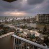
Seeing the winds in Montego Bay, it's hard to comprehend what the winds were like near the eye wall when Melissa made landfall. Unreal.
These were the last correspondences from Josh Morgerman before the eyewall was even over him.
It's a little concerning we haven't heard anything else from him by now.
I'm sure he's fine. It may be a few days before we hear from him. It probably depends on the condition of the airports. I think there are two major airports on the island, plus other smaller landing strips. Sangster might be down a few days, but Fleming is on the eastern side of the island. The question would be how long it would take for him to get there.
I think it might have been Maria that hit Puerto Rico where we went about a week before we heard from him.
Kds86z
Member
tornado examiner
Member
Yeah it's being spread around the internet of course, debris high up in the air. Drone footage. None of the buildings line up at all. Lmfao. Somehow numerous are falling for it, we’re a goner species.Ok gotcha
- Admin
- #1,451
- Messages
- 2,408
- Reaction score
- 2,229
- Location
- Meridianville, Al
- Special Affiliations
- SKYWARN® Volunteer
Save the climate change discussions for another thread
Thats insane. Thanks for framing it for me.4/3/1974, 4/27/2011, this is literally the hurricane equivalent to a super outbreak.
There was just so much warm ocean air to begin with that I expect it will be hard to know. The depth of the warm water was just unprecedented - and it had remained virtually unstirred for a lot longer than usual. Orographic lift and any channeling effect would have been after it turned north, and there's no doubt that the eastern side "blobs" fired off heavily right as it did that. I wondered at the time if maybe there was some channeling going there, as it looked like a convection traffic jam. I expect there's a lot that will be studied about Melissa for years to come.Is it possible the mountains helped channel warm ocean air into the eye, and that's why it maintained its strength for so long? There are numerous stories of mountain slopes rapidly intensifying tornadoes, so I'm wondering if those same dynamics could've been at play here.
lake.effect
Member
Yeah it's being spread around the internet of course, debris high up in the air. Drone footage. None of the buildings line up at all. Lmfao. Somehow numerous are falling for it, we’re a goner species.
Text to image generation models are like only 2 years old and already hard to distinguish from reality. Don’t kid yourself - in 6-12 months, they will be fooling everyone including you and me
notsoencrypted
Member
As we wait for news, images, and videos from Jamaica, please be very, very cautious. Short videos and images on social media especially will be hard to verify, so try to wait for stuff from reliable sources. <3
Kds86z
Member
Bingo. The warm uninterrupted water.There was just so much warm ocean air to begin with that I expect it will be hard to know. The depth of the warm water was just unprecedented - and it had remained virtually unstirred for a lot longer than usual. Orographic lift and any channeling effect would have been after it turned north, and there's no doubt that the eastern side "blobs" fired off heavily right as it did that. I wondered at the time if maybe there was some channeling going there, as it looked like a convection traffic jam. I expect there's a lot that will be studied about Melissa for years to come.
tornado examiner
Member
Unfortunately.Text to image generation models are like only 2 years old and already hard to distinguish from reality. Don’t kid yourself - in 6-12 months, they will be fooling everyone including you and me
Kds86z
Member
Thanks @tornado examiner will have to be more careful.Yeah it's being spread around the internet of course, debris high up in the air. Drone footage. None of the buildings line up at all. Lmfao. Somehow numerous are falling for it, we’re a goner species.
Late reply but I had to respond. This is a misconception I held for a long time until I dug deeper. Once you get to the very top of the Saffir-Simpson scale, you actually do start to see damage comparable to a violent tornado, albeit usually in isolated spots.I was under the impression that Andrew had damage in the EF3 range. In another thread, if anyone has any instances of Andrew’s damage pointing to EF4 or higher intensity, I’d love to be proven wrong here.
Andrew - Damage in the Naranja area was comparable to low end F4, including flattened one story condominium buildings.
Michael - Borderline violent damage including debarked trees and leveled buildings in the eastern fringes of the Panama City metro and at Tyndall AFB.
Irma - Debarked trees, severe damage to concrete buildings, and leveled homes were documented in the most violent parts of the eyewall in the Caribbean.
Dorian - Most violent hurricane eyeball damage I have ever seen. Anchor bolted homes in the Bahamas were leveled or slabbed far inland away from the storm surge. Entire forests were shredded and partially debarked. Large heavy objects like shipping containers were thrown.
I don’t have the patience to go back and dig all this up, but there are some photos posted by myself and others somewhere on a tropical events thread showing some of these instances of damage. In any case, I imagine we’ll see some damage from Melissa comparable to what I just described.