
Oh. I didn’t know that. What about Matthew?Potentially Strongest landfall in that area of Cuba since Inez back in 1960 something.
Navigation
Install the app
How to install the app on iOS
Follow along with the video below to see how to install our site as a web app on your home screen.
Note: This feature may not be available in some browsers.
More options
-
Welcome to TalkWeather! We see you lurking around TalkWeather! Take the extra step and join us today to view attachments, see less ads and maybe even join the discussion. CLICK TO JOIN TALKWEATHER
You are using an out of date browser. It may not display this or other websites correctly.
You should upgrade or use an alternative browser.
You should upgrade or use an alternative browser.
Hurricane Melissa
- Thread starter Jacob Aden
- Start date
Orographic lift and any channeling effect would have been after it turned north, and there's no doubt that the eastern side "blobs" fired off heavily right as it did that. I wondered at the time if maybe there was some channeling going there, as it looked like a convection traffic jam. I expect there's a lot that will be studied about Melissa for years to come.
Fascinating. I didn't notice the blobs, and am not familiar with the topography of Jamaica, so wasn't watching that closely. I did notice the eye stayed symmetrical while shrinking as it went inland. A shrinking eye is usually associated with a strengthening hurricane, right?
I think it was the NHC that said the wind was supposed to be up to 30% stronger up in the mountains, which seems almost impossible to believe, because that would calculate from 185 mph sustained winds to 240 mph, and 215 mph gusts to 280 mph.
There's a lot of people holding their breath currently, hoping that what might've just happened, didn't actually happen.
akt1985
Member
1966Potentially Strongest landfall in that area of Cuba since Inez back in 1960 something.
lake.effect
Member
Melissa's center appears to be fully over open water now and cold cloud cover is rapidly returning around the CDO. No eye yet
tornado examiner
Member
Thanks1966

Kolle
Member
Jamaican EMA spokesman says, unfortunately, some water rescues had to be abandoned due to conditions but is unable to give a death toll at the moment.
tornado examiner
Member
It is my guess that in post analysis the data will allow for an upgrade to 190mph 890mb or something around there.
That sentinal image really does speak for itself. This thing intensified for as long as it possibly could all the way up to landfall.
That sentinal image really does speak for itself. This thing intensified for as long as it possibly could all the way up to landfall.
From Jamaican government briefing, emergency responders are likely going to have to wait a bit before mounting a wider response. Sounds like there are a variety of different logistical issues, and rescues during landfall were mostly impossible. Additionally, outside aid will not be coming immediately. On the plus side, Kingston's airfields should be in at least okay shape, so cargo planes will be able to land there.
tornado examiner
Member
Melissa at 954mb now with recon.
They have a tendency to tighten up as they make landfall, like it almost shrinks away from the land - I've seen that in many landfalling systems. In this case, I can not imagine what that would have unleashed.Fascinating. I didn't notice the blobs, and am not familiar with the topography of Jamaica, so wasn't watching that closely. I did notice the eye stayed symmetrical while shrinking as it went inland. A shrinking eye is usually associated with a strengthening hurricane, right?
I think it was the NHC that said the wind was supposed to be up to 30% stronger up in the mountains, which seems almost impossible to believe, because that would calculate from 185 mph sustained winds to 240 mph, and 215 mph gusts to 280 mph.
There's a lot of people holding their breath currently, hoping that what might've just happened, didn't actually happen.
The mountains are going to be more of a mess than I think many will have been expecting. Wind channeling will definitely have occurred, just like it does in big cities around skyscrapers, albeit on a much broader scale. So there will be places where gusts were really enhanced by the topography. But similarly, there will likely be places that were sheltered, being in a lucky spot. I hope it's not as terrible as we fear, and I am also hopeful because of the path of the storm that some eastern areas of the island may be relatively OK overall. Anxious to see.
lake.effect
Member
Core of Melissa took a beating but is still intact and already recovering. I think a return to cat 5 is unlikely at this point, but a strong cat 4 is reasonable.
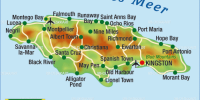
There's only one highway connecting Kingston to Black River and Montego bay (red line in first image). It's very likely the Southeast section of the Island will be inaccessible by road for several days or weeks. The hurricane hit right at the mountains where there are the least alternate routes.


Attachments
She sure is disturbingly symmetrical still. Not much time unimpeded though. Seems to have jogged east some after coming off the coast again.Core of Melissa took a beating but is still intact and already recovering. I think a return to cat 5 is unlikely at this point, but a strong cat 4 is reasonable.
lake.effect
Member
Side note, iCyclone aka Josh Morgermann was holed up in a small town called Crawford on the southeast coast. The northeast eyewall went directly over that location at peak strength.
He hasn’t tweeted since 10am. He survived Dorian and knows what he’s doing, but it’s still a bit unnerving. He’s probably out helping with rescues or immediate relief efforts right now. If he made it through he will have the most violent hurricane footage of all time, 210+ mph gusts on camera for an hour. Pure terror
He hasn’t tweeted since 10am. He survived Dorian and knows what he’s doing, but it’s still a bit unnerving. He’s probably out helping with rescues or immediate relief efforts right now. If he made it through he will have the most violent hurricane footage of all time, 210+ mph gusts on camera for an hour. Pure terror
This Eastern turn is happening right over the northern section of the main highway, which really sucks because that was the best chance of getting supplies and rescue crews in. It's literally traveling parallel with that highway. I'm assuming the Southern route is already completely inundated or even destroyed.

tornado examiner
Member
Melissa finally made her eye wall replacement cycle and is immediately improving on infrared. With the CDO becoming rounder and brighter with each new frame.
Central Ohio Wx
Member


tornado examiner
Member
That is some truely insane vegetation damage.
akt1985
Member
I’m reading from various news outlets that the death toll from Melissa stands at seven. However, some of the deaths were in Haiti and the Dominican Republic.