CheeselandSkies
Member
It's weird, on my GR Level 3 for some NEXRAD sites I get scan updates every 2-3 (or even 1) minutes, and others (including, apparently, KSHV) only every 6-7. Annoying.
Follow along with the video below to see how to install our site as a web app on your home screen.
Note: This feature may not be available in some browsers.
Hope you get to come home soon. Being home is Better than being in hospital.Storms are starting to fire on the dryline here in Texas and here I am stuck in the hospital with my foot bandaged up and I can't run ha ha ha ha. I am an interior room in case the impossible happens Good news is the doctor said she took care of everything with my infection and if I'll be really careful I can be up and around again in three to four weeks but more importantly I can be back home in a couple of days in my armchair to chase the storms around with you guys. I'm really surprised that we are in the tornado risk because that is like I said before Tornado risk is rare in this part of Central Texas so this system must have some punch to it. I would be really careful if you were north or east of Central Texas.
BTW May 4th was the 100th anniversary of the Austin Twin tornadoes, one of the few strong tornadoes have struck this area outside of Jerrell of course which was quite a bit north of downtown.
May 22 Anniversary Tornadoes
Main forecast concern through the short term remains potent
convection potential ahead of frontal boundary as it moves
through the state.
The SPC has now upgraded the Day 2 outlook to include an Enhanced
Risk of Severe Storms for Friday. Models are in general agreement
with showing brief/light rain possible early morning, with the
main line of storms moving into northwest Georgia by midmorning.
Despite the early start, sufficient surface heating ahead of the
boundary will allow for increased destabilization. HREF guidance
shows finger of 2000 J/kg MUCAPE spreading into west central
Georgia by 12 PM/16 UTC, along with 100-200 m2/s2 SRH and 40-50kt
850 jet over the CWA. This environment will promote supercells or
bowing QLCS with concerns of damaging winds and hail possible up
to 1". SPC has also included a 10% tornado risk for a large
portion of western/central Georgia, including portions of the
south Metro Atlanta and Columbus areas.
The main convection line looks to move through the metro Atlanta
area by 18-19 UTC (2-3PM), and move through the Macon area by 21
UTC (5PM). Clearing/improvement is expected behind the line, but
wrap around moisture could keep some light returns and enhanced
cloud cover over the area, particularly over north Georgia, into
Saturday. Winds will remain gusty into the evening hours.
Caveat with this event - should convection move faster
than expected, destabilization may be limited with lack of
heating, effectively cutting off portions of the state from the
severe threat. While increasing confidence supports the Enhanced
Risk, this caveat is still a real possibility.
The timing change comes into play when they are on SAILS mode. It eleminates the upper level scans, so they get more frequent updates when things are changing quickly....It's weird, on my GR Level 3 for some NEXRAD sites I get scan updates every 2-3 (or even 1) minutes, and others (including, apparently, KSHV) only every 6-7. Annoying.
The timing change comes into play when they are on SAILS mode. It eleminates the upper level scans, so they get more frequent updates when things are changing quickly....
Yep !!Well, it seems certain offices routinely forget to change it during tornado events...
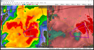
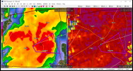
Yep. I just noticed that TDS north of Mount Enterprise, TX.Another tornado on the ground.
It's weird, on my GR Level 3 for some NEXRAD sites I get scan updates every 2-3 (or even 1) minutes, and others (including, apparently, KSHV) only every 6-7. Annoying.
NEXRAD radars have a mode called SAILS (Supplemental Adaptive Intra-Volume Low-Level Scan). You can actually see which SAILS mode the radar is in on your GR software in the bottom center/right (iirc, away from PC right now). Basically, it adds low level volume scans during a radar scan loop.Same way with WSV3. Guess it's whatever mode the NWS has it in.