Parker Copeland
Member
uh no, unless a massive deathrun level uptrend occurs, we not getting mdtYeah. I can see a small moderate setting up down southern. Miss. Southeast Arkansas and northern Louisiana
Follow along with the video below to see how to install our site as a web app on your home screen.
Note: This feature may not be available in some browsers.
uh no, unless a massive deathrun level uptrend occurs, we not getting mdtYeah. I can see a small moderate setting up down southern. Miss. Southeast Arkansas and northern Louisiana
For wind damage it's not that unlikely.uh no, unless a massive deathrun level uptrend occurs, we not getting mdt
Be wind drivenuh no, unless a massive deathrun level uptrend occurs, we not getting mdt
no, when was the last time a wind driven mdt has actually verified in Dixie lmao, prob won't happenFor wind damage it's not that unlikely.
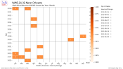
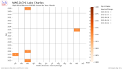
Something I keep eye on. That a rather large enhanced out for nowno, when was the last time a wind driven mdt has actually verified in Dixie lmao, prob won't happen
May 26th 2024, although that was a bit north of the deep south, still technically in Dixieno, when was the last time a wind driven mdt has actually verified in Dixie lmao, prob won't happen
I mean, mainly the gulf states, wind events just, fail to verify the vast majority of the time, so unless if we get a 12/15/21 type beat, we prob won't get a wind driven mdt down there due to recent wind driven mdts not doing much at allMay 26th 2024, although that was a bit north of the deep south, still technically in Dixie
April 10 2024. Verified. A lot of Dixie wind moderates verify lolI mean, mainly the gulf states, wind events just, fail to verify the vast majority of the time, so unless if we get a 12/15/21 type beat, we prob won't get a wind driven mdt down there due to recent wind driven mdts not doing much at all
sig winds, did that have a lot of sig wind reports, if a 30# nado risk happens and like 2 sigs and 3 non sigs happen, does that verify the 30#?April 10 2024. Verified. A lot of Dixie wind moderates verify lol
I don't think this is a fair comparison because the conditions that warrant a 30# wind risk happen much more frequently than conditions that warrant a 30# tornado risk, so of course there's more examples where they don't verify.sig winds, did that have a lot of sig wind reports, if a 30# nado risk happens and like 2 sigs and 3 non sigs happen, does that verify the 30#?

Day 2 Convective Outlook
NWS Storm Prediction Center Norman OK
1133 AM CST Mon Mar 03 2025
Valid 041200Z - 051200Z
...THERE IS AN ENHANCED RISK OF SEVERE THUNDERSTORMS FOR PARTS OF
SOUTHEAST OK...NORTHEAST TX...SOUTHERN AR...CENTRAL/NORTHERN
LA...CENTRAL/SOUTHERN MS...SOUTHWEST AL...AND THE WESTERN FL
PANHANDLE...
...SUMMARY...
Severe thunderstorms with a threat of tornadoes, damaging winds, and
isolated hail are possible on Tuesday from eastern portions of the
southern Plains into the lower Mississippi Valley and Southeast. A
couple strong tornadoes will be possible.
...Synopsis...
A strong and deep mid/upper-level shortwave trough and embedded
midlevel cyclone will move eastward from the central/southern Great
Plains into the Mississippi Valley on Tuesday. A deepening surface
cyclone is forecast to move eastward across KS through the day, and
then northeastward across parts of MO/IL Tuesday night. Relatively
modest low-level moisture (with dewpoints in the 40s/low 50s F) will
stream northward within the warm sector of this cyclone into parts
of the Midwest, with richer moisture (60s F dewpoints) remaining
confined to parts of the lower Mississippi Valley and Southeast.
...ArkLaTex region into the Lower Mississippi Valley and
Southeast...
Organized convection will likely be ongoing at the start of the
forecast period Tuesday morning across parts of eastern OK/TX and
perhaps southeast KS. The extent to which the morning convection
will become surface-based remains somewhat uncertain, but very
strong low-level and deep-layer shear and sufficient instability
will support a conditional risk of all severe hazards with the
early-day storms as they approach the ArkLaTex region.
A strongly sheared QLCS is expected to approach the lower
Mississippi Valley region by early afternoon. The magnitude of the
severe threat with this QLCS, as well as the potential for preceding
supercells, will be determined by the extent to which low-level
moistening can keep pace with the primary convective line. Very
strong flow in the lowest 3 km and 0-1 km SRH increasing above 400
m2/s2 will support a threat of potentially widespread damaging winds
and line-embedded tornadoes wherever the organized QLCS can remain
near-surface-based. The potential for longer-lived supercells is
more uncertain, but cannot be ruled out immediately ahead of the
QLCS, and also where large-scale ascent is somewhat weaker in closer
proximity to the Gulf Coast. Any persistent discrete or embedded
supercells could pose a threat of a strong tornado within the very
strongly sheared environment.
The northern/eastern extent of organized severe potential into
Tuesday night will be constrained by increasingly prohibitive
low-level stability. However, given the strength of the flow fields,
any organized convection that persists into late Tuesday and early
Wednesday could pose some risk of damaging wind, with some tornado
threat potentially persisting in closer proximity to the Gulf Coast.
...Parts of eastern Kansas into Missouri...
A few strong elevated storms could persist into Tuesday morning
across parts of eastern KS into MO, potentially posing some threat
of hail and locally gusty winds. The extent of diurnal heating in
the wake of morning convection remains uncertain, but some
surface-based destabilization will be possible during the afternoon
as the midlevel cyclone and attendant cold temperatures aloft move
over the region. If sufficient heating/destabilization can occur,
then robust storm development will be possible in the vicinity of
the eastward-moving cyclone, posing a risk of isolated hail, strong
gusts, and possibly a tornado.
..Dean.. 03/03/2025
Popcorn time

I agree, I was just trying to make a point that the SPC generally does a pretty good job and if they say there's a wind-risk then there probably will be. Regardless of the colors there's a damaging storm system coming through. Even up by me in the marginal risk, there's a chance for some cold-core supercells in Eastern KS/Western MO if things play out right.No point in getting caught up in the colors, as Spann would say. Wind and at least some tornado threat from the ArkLaTex all the way to east AL. A few rounds, close together also seem possible, based on the model depictions, with some showing a bunch of clusters advancing versus a single QLCS. In any case, fresh batteries in those weather radios and flashlights would be a good call.
I know for sure we had one in 2001 when a derecho came through. I was pregnant with my son, had trouble getting home from work/classes at Mississippi State, and my husband had to work 24 straight hours on base. We didn’t get electricity back for over a week and things like cable/internet took about a month. They are rare (and don’t think this will be anything like that - likely like the last system), but wind driven events do occasionally happen here.no, when was the last time a wind driven mdt has actually verified in Dixie lmao, prob won't happen
Sit back and watch the show (only a meme, please stay safe and take shelter if you are in the path of any of this upcoming weather)Popcorn time

My mom talks about that one all the time. I don't remember it. We are honestly overdo for a major derecho thoughI know for sure we had one in 2001 when a derecho came through. I was pregnant with my son, had trouble getting home from work/classes at Mississippi State, and my husband had to work 24 straight hours on base. We didn’t get electricity back for over a week and things like cable/internet took about a month. They are rare (and don’t think this will be anything like that - likely like the last system), but wind driven events do occasionally happen here.
This one is better:Sit back and watch the show (only a meme, please stay safe and take shelter if you are in the path of any of this upcoming weather)
View attachment 34483