
Anybody able to post the 06Z GFS ensemble runs? How do you get those that you post @JPWX ?
Navigation
Install the app
How to install the app on iOS
Follow along with the video below to see how to install our site as a web app on your home screen.
Note: This feature may not be available in some browsers.
More options
-
Welcome to TalkWeather! We see you lurking around TalkWeather! Take the extra step and join us today to view attachments, see less ads and maybe even join the discussion. CLICK TO JOIN TALKWEATHER
You are using an out of date browser. It may not display this or other websites correctly.
You should upgrade or use an alternative browser.
You should upgrade or use an alternative browser.


.png")

- Thread starter
- #24
Weatherbell subscriptionAnybody able to post the 06Z GFS ensemble runs? How do you get those that you post @JPWX ?
Parker Copeland
Member
so, signal only improves......not a grand trend and spc alr mentions pot severe episodes, just don't know where to pinpoint areas for outlooks
- Thread starter
- #26
Parker Copeland
Member
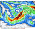
yeah, still a ways out, that look can always appear in no timeNot your "classic" severe setup, but still, the 00z Euro/12z Canadian 500mb looks like a legit significant threat.
Maybe not classic in a typical sense, but systems like that have historically made for pretty serious events in this part of the world.Not your "classic" severe setup, but still, the 00z Euro/12z Canadian 500mb looks like a legit significant threat.
I mean, shoot, look at the precipitation presentation on the Euro.Maybe not classic in a typical sense, but systems like that have historically made for pretty serious events in this part of the world.

- Thread starter
- #30
Exactly. That's why I put classic in quotes.Maybe not classic in a typical sense, but systems like that have historically made for pretty serious events in this part of the world.
- Thread starter
- #31
O jeez. Yeah that would be a problem. What's the central pressure on that? 985mb near Great LakesI mean, shoot, look at the precipitation presentation on the Euro.
View attachment 34142
990 over NE Missouri and then goes all the way down to 982 as it passes over Michigan and Toronto.O jeez. Yeah that would be a problem. What's the central pressure on that? 985mb near Great Lakes
KevinH
Member
yeeaaaahhhhh not a fanI mean, shoot, look at the precipitation presentation on the Euro.
View attachment 34142
- Thread starter
- #34
Strengthening low pressure. Yep that would be a HUGE problem for us. Not only would you get significant backing of winds which in turn would increase tornado potential, but it would also provide potential for a secondary low pressure formation as well.990 over NE Missouri and then goes all the way down to 982 as it passes over Michigan and Toronto.
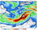
It's kept that presentation for the last 2 long-range runs, anxious to see if it continues. GFS is all over the place, 06Z run was an absolute nothing-burger and 12Z is back to something completely different from Euro, but could still cause some problems.Strengthening low pressure. Yep that would be a HUGE problem for us. Not only would you get significant backing of winds which in turn would increase tornado potential, but it would also provide potential for a secondary low pressure formation as well.
Parker Copeland
Member
ouch, just ouchI mean, shoot, look at the precipitation presentation on the Euro.
View attachment 34142
- Thread starter
- #37
Yeah. Goofy Forecast System hints at it then backs off then comes back. I've found most of the time that the GFS usually hints at long range severe weather first, but is typically late to the party after the Euro/Canadian picks up on it..It's kept that presentation for the last 2 long-range runs, anxious to see if it continues. GFS is all over the place, 06Z run was an absolute nothing-burger and 12Z is back to something completely different from Euro, but could still cause some problems.
tennessee storm chaser
Member
- Messages
- 1,877
- Reaction score
- 4,288
- Location
- jackson tennessee
- Special Affiliations
- SKYWARN® Volunteer
Also with a slp gaining strength as it moves northeast , would increase height falls which would increase a severe threat pretty far down south towards coast even. Yeah 12z looks it’s trying to get the original look back from last nights 0z run from last nite … which does t surprises me since 6z suits don’t getStrengthening low pressure. Yep that would be a HUGE problem for us. Not only would you get significant backing of winds which in turn would increase tornado potential, but it would also provide potential for a secondary low pressure formation as well.
Fully data loaded in this far out …I pay more attention to 0z and 12 z runs. When the system is past 48 hours out still
MattW
Member
- Messages
- 388
- Reaction score
- 382
- Location
- Decatur, GA
- HAM Callsign
- KG4GUF
- Special Affiliations
- SKYWARN® Volunteer
I was wondering about this. This morning when I woke up and looked at the models, I said to myself "We're in that wonky GFS dead zone aren't we?" But it seems that on the 12z runs, it's starting to ramp back up a bit.Yeah. Goofy Forecast System hints at it then backs off then comes back. I've found most of the time that the GFS usually hints at long range severe weather first, but is typically late to the party after the Euro/Canadian picks up on it..
