Kds86z
Member
the instability was insane that day…very rareye, 4/27 was leftovers and hyper airmass recovery
Follow along with the video below to see how to install our site as a web app on your home screen.
Note: This feature may not be available in some browsers.
the instability was insane that day…very rareye, 4/27 was leftovers and hyper airmass recovery
Definitely. It was time to change classes that afternoon and I walked outside. I have never in my life experienced the smell and taste of moisture like I experienced at that moment when I walked outside the school. It was then that I became aware that okay something is definitely wrong here. The only thing I can describe it felt like I was swimming in a warm/moist ocean of air.the instability was insane that day…very rare
wow, that's wild, I hope I don't have to deal with that at some point, insane stuffDefinitely. It was time to change classes that afternoon and I walked outside. I have never in my life experienced the smell and taste of moisture like I experienced at that moment when I walked outside the school. It was then that I became aware that okay something is definitely wrong here. The only thing I can describe it felt like I was swimming in a warm/moist ocean of air.
12z euro is a more northerly track than the 00z.
Hello there, 12Z GFS. GFS has been all over the place, though, so 10 dollars this changes at least 3 more times between now and then.
View attachment 34181

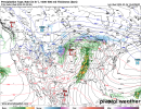
Man that's a massive long wave trough.Hello there, 12Z GFS. GFS has been all over the place, though, so 10 dollars this changes at least 3 more times between now and then.
View attachment 34181

This looks like a bit too much divergence aloft leading to overconvection, you can see the split in the jet over Mississippi, which would lead to widespread strong vertical velocities and too much convection. You either want this trough to deamplify a bit or for it to shift a bit north (if you're looking to maximize the severe threat).
Much less time for moisture return after the weekend cold front coming down. The Tuesday/Wednesday system will be a tornado threat in the Southeast, but there will be questions about how far north moisture and instability comes, because it may be a rapid last minute return. There will be a ceiling on next week's threat that is substantially way lower than the day you're hinting at for the upper-air pattern.The divergent flow that is being modelled is so eerily similar to the day that shall not be named. Praying that things downtrend.
Good to hear. I'd really rather not have anything remotely similar ever come to fruition. It's been fourteen years and it's still fresh in my mind.Much less time for moisture return after the weekend cold front coming down. The Tuesday/Wednesday system will be a tornado threat in the Southeast, but there will be questions about how far north moisture and instability comes, because it may be a rapid last minute return. There will be a ceiling on next week's threat that is substantially way lower than the day you're hinting at for the upper-air pattern.
Yep… I am 100% sure it will, lolThis is still a week away. A lot can change by then
What's the range? 24 hours?I used AI to create a tornado prediction model that uses quantum effects (entanglement, quantum states, etc) to a remarkable degree. It's honestly crazy good. I'm finalizing the visualization but am eager to test it on the upcoming event.