
That's not good, well they typically do expand as we get closer though I always forget about that.Tbf it has been expanding incrementally run-to-run.
Navigation
Install the app
How to install the app on iOS
Follow along with the video below to see how to install our site as a web app on your home screen.
Note: This feature may not be available in some browsers.
More options
-
Welcome to TalkWeather! We see you lurking around TalkWeather! Take the extra step and join us today to view attachments, see less ads and maybe even join the discussion. CLICK TO JOIN TALKWEATHER
You are using an out of date browser. It may not display this or other websites correctly.
You should upgrade or use an alternative browser.
You should upgrade or use an alternative browser.
At least it's better than the NAM, which starts small and stays small until like 3 hours before an event beginsThat's not good, well they typically do expand as we get closer though I always forget about that.

Ive been checking the theta e some. It looks like when the QCLS/broken supercell line. Gets too Alabama that instability is going to be more refined to central Alabama and South and same into Georgia. But places west will be a bit further north. The instability looks similar to our last QLCS tornado outbreakAt least it's better than the NAM, which starts small and stays small until like 3 hours before an event begins
Yeah, with the slower timing it'll be a proper nighttime event in AL and parts of GA (if chronology holds). In all scenarios it looks pretty nasty for ArkLaMiss.Ive been checking the theta e some. It looks like when the QCLS/broken supercell line. Gets too Alabama that instability is going to be more refined to central Alabama and South and same into Georgia. But places west will be a bit further north. The instability looks similar to our last QLCS tornado outbreak
No more whack-a-mole spin ups in Alabama please.Yeah, with the slower timing it'll be a proper nighttime event in AL and parts of GA (if chronology holds). In all scenarios it looks pretty nasty for ArkLaMiss.
Hard agree.No more whack-a-mole spin ups in Alabama please.
KevinH
Member
Pictures or it didn’t happen lolNewest GFS run screams supercells. The warm sector is a bit small though
Notice all the streaks.Pictures or it didn’t happen lol
And also the simulated radar.


NWS BMX AFD
"southerly flow returns through the day Monday, allowing for a
steady increase in moisture. Meanwhile, a shortwave will eject
across the Tennessee Valley early next week as an upper low
deepens across the Four Corners region. This will bring a low
chance of showers back to the area Monday and Tuesday. The upper
low to our west will eject across the Plains by midweek, sending
another front our way. Southerly flow will become a bit breezy on
Tuesday as the surface low deepens across the Plains. We will see
an increasing chance for strong to potentially severe
thunderstorms Tuesday night into Wednesday morning as a result.
There are a few details that we will be able to narrow in on in
this coming days that will help us better define the severe threat
locally. The main concern is just unstable we become. Latest
guidance suggests a moderate chance for dewpoints over 60F so we
will need to keep an eye on that. However, a lot can change over
the coming days. With that said, wind shear will not be an issue
with select forecast soundings hinting at 60-70 knots. SPC already
has a slight risk in place across Central Alabama with an
Enhanced Risk to our west. There is potential for all forms of
severe weather so continue to check back in the coming days. Drier
conditions are in store behind this system as high pressure
builds in."
I think something to watch for is how strong the primer low will be on Monday, seems the GFS is the only one that shows it currently though. That may help some areas with better moisture (especially if the LLJ on it is strong). Interesting feature to watch in the coming days 
Last edited:
MattW
Member
- Messages
- 388
- Reaction score
- 382
- Location
- Decatur, GA
- HAM Callsign
- KG4GUF
- Special Affiliations
- SKYWARN® Volunteer
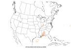
Traditional ingredients may not be as prevalent on current GFS runs, but it seems SHERB is popping for Alabama.

It actually looks like those highest values are behind the front, with the slightly lower values of 1.2 and 1.4 over the Carolinas and Virginia being in the WS. SHERB can produce some wacky values because it's trying to calculate tornadogenic conditions in HSLC setups.Traditional ingredients may not be as prevalent on current GFS runs, but it seems SHERB is popping for Alabama.
View attachment 34230
KevinH
Member
Where did you find this? I have never heard of SHERB.Traditional ingredients may not be as prevalent on current GFS runs, but it seems SHERB is popping for Alabama.
View attachment 34230
MattW
Member
- Messages
- 388
- Reaction score
- 382
- Location
- Decatur, GA
- HAM Callsign
- KG4GUF
- Special Affiliations
- SKYWARN® Volunteer
It's under the Severe tab here: https://www.eas.slu.edu/CIPS/MODEL/WXmodel.phpWhere did you find this? I have never heard of SHERB.
KevinH
Member
Thank youIt's under the Severe tab here: https://www.eas.slu.edu/CIPS/MODEL/WXmodel.php
Jason Mills
Member
It actually looks like those highest values are behind the front, with the slightly lower values of 1.2 and 1.4 over the Carolinas and Virginia being in the WS. SHERB can produce some wacky values because it's trying to calculate tornadogenic conditions in HSLC setups.
Fun tidbit: SHERBE attempts to correct for the wonky high values SHERB can produce. The difference being the fixed layer shear term is swapped for EBWD.
https://www.spc.noaa.gov/exper/mesoanalysis/help/help_sherbe.html
MattW
Member
- Messages
- 388
- Reaction score
- 382
- Location
- Decatur, GA
- HAM Callsign
- KG4GUF
- Special Affiliations
- SKYWARN® Volunteer
So then on my link would that be the Effective SHERB?Fun tidbit: SHERBE attempts to correct for the wonky high values SHERB can produce. The difference being the fixed layer shear term is swapped for EBWD.
https://www.spc.noaa.gov/exper/mesoanalysis/help/help_sherbe.html
Jason Mills
Member
YepSo then on my link would that be the Effective SHERB?
MattW
Member
- Messages
- 388
- Reaction score
- 382
- Location
- Decatur, GA
- HAM Callsign
- KG4GUF
- Special Affiliations
- SKYWARN® Volunteer

KevinH
Member
That doesn’t look good