
I know! To tell you the truth, I'm concerned for people in Monroe County trying to find shelter. Thankfully, we installed a safe room inside our new house when we moved in back during Spring 2012.Your gunna have to watch out that Smithville magnet will be in play once again lol
Navigation
Install the app
How to install the app on iOS
Follow along with the video below to see how to install our site as a web app on your home screen.
Note: This feature may not be available in some browsers.
More options
-
Welcome to TalkWeather! We see you lurking around TalkWeather! Take the extra step and join us today to view attachments, see less ads and maybe even join the discussion. CLICK TO JOIN TALKWEATHER
You are using an out of date browser. It may not display this or other websites correctly.
You should upgrade or use an alternative browser.
You should upgrade or use an alternative browser.
Severe WX March 30th- April 1st 2023 (South, Southeast, Ohio Valley, Upper Midwest)
- Thread starter Lake Martin EF4
- Start date
Good question @Lake Martin EF4 think you can change it to add Tennessee?Any reason the updated name of this thread doesn’t include TN?
- Moderator
- #163
Good question @Lake Martin EF4 think you can change it to add Tennessee?
It doesn't have MS or AL either.
The EHI is very high in the moderate according to the RAP.

Last edited by a moderator:
- Admin
- #165
Added, AL, TN, and MS to the title. I do not think I am a fan of putting all of the states behind it. To me anything after the year gets ignored.Good question @Lake Martin EF4 think you can change it to add Tennessee?
There's going to be some messy convection out in front of this. That could be why they've restricted the moderate area somewhat.I'm curious though as to why they have the Mid-South Moderate Risk so small. I would expand it south and eastward. We'll see. Just my two cents.
Thanksgivingbrown
Member
I agree it gets ignored and it clogs up the title. It’s too busy. Open the thread and within a few post you’ll see where the threat area liesAdded, AL, TN, and MS to the title. I do not think I am a fan of putting all of the states behind it. To me anything after the year gets ignored.
- Admin
- #168
To avoid this taking up this thread, I am going to talk with the moderators and admins and we will make a decision on what to do there.I agree it gets ignored and it clogs up the title. It’s too busy. Open the thread and within a few post you’ll see where the threat area lies
Y'all could go with a broad area delineation perhaps, for example "Midwest/Southeast."To avoid this taking up this thread, I am going to talk with the moderators and admins and we will make a decision on what to do there.
12z hrrr is unimpressive... But that's the long range hrrr for ya lol
What parts were unimpressive about it?12z hrrr is unimpressive... But that's the long range hrrr for ya lol
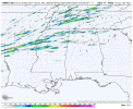
I just looked at UH again and a few of the models now consistently show a streak that traverses across Illinois and into Indiana.
That streak into southwestern KY is showing up again too.
The updrafts swaths are not as impressive has say the WRF. The hrrr will gradually uptick though as we get closer. It's usual patternWhat parts were unimpressive about it?
I just looked at UH again and a few of the models now consistently show a streak that traverses across Illinois and into Indiana.
That streak into southwestern KY is showing up again too.
To me the WRF is the most reliable at this range.
Yeah we’ve kind of went back and forth on a love/hate with HRRR this severe season lol.The updrafts swaths are not as impressive has say the WRF. The hrrr will gradually uptick though as we get closer. It's usual pattern
To me the WRF is the most reliable at this range.
The RAP and WRF are my go to's at this range. Which the RAP indicates a impressive non contaminated environment with a very high Energy Helicity index and the WRF shows there being potentially many strong supercells with a accompanying tornado threat lines up across the mid south into portions of the the deep south.Yeah we’ve kind of went back and forth on a love/hate with HRRR this severe season lol.
NAM 3Km really likes the northern moderate spot but displays everything congealing into a line pretty quickly.
I really think on the 12z run it’s under forecasting the southern threat area. It’s mainly just showing a line developing in far eastern Arkansas before moving into Tennessee. A bit different and not as bad as yesterdays run
I really think on the 12z run it’s under forecasting the southern threat area. It’s mainly just showing a line developing in far eastern Arkansas before moving into Tennessee. A bit different and not as bad as yesterdays run
The nasty swath to the north is very close to the 12/10/21 path and actually crosses, ending just beyond Mayfield.the HRW-WRF is on to something truly nasty.
Nadocast throwing out a lot of color tomorrow
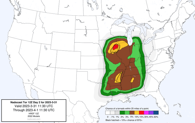
I know Arkansas is 10% which is high, but I don’t understand why it’s not higher or on par with the northern risk area.Nadocast throwing out a lot of color tomorrow
I think any cells that fire down there will be able to remain discrete for a longer period of time than any up north, with the deeper shear vectors favoring a more discrete mode at first, and with access to some really good parameters. However, that’s only my opinion.
Eazzzye2003
Member
Triple point, greater forcing. Lower risk area, less forcing but deeper moisture.