• Welcome to TalkWeather!
    We see you lurking around TalkWeather! Take the extra step and join us today to view attachments, see less ads and maybe even join the discussion.
    CLICK TO JOIN TALKWEATHER

Severe WX March 30th- April 1st 2023 (South, Southeast, Ohio Valley, Upper Midwest)

The cell near Memphis seems to be going in 'waves' of weakening and strengthening. The environment is still favourable - I still think it may attempt reorganisation a couple more times and eventually drop a strong tornado.
 
Yeah for whatever reason it's just not able to sustain the low-level circulation. Not sure why, but if it does manage to get its act together it could put down a big one because the parameters there are still very favorable.
 
Getting quite a bit of inhibition that's no doubt killing new cell growth in that area at this point, but with such a well established cell that shouldn't be an issue; I think we are perhaps seeing the sign of a new meso forming at this point so it could be cycling
 
I believe the Tunica cell is simply cycling right now. Worried it will get its act together right as it heads into the more populated areas south of Memphis.
 
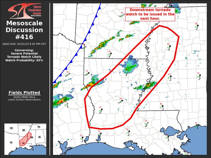
MESOSCALE DISCUSSION 0416
NWS STORM PREDICTION CENTER NORMAN OK
0742 PM CDT FRI MAR 31 2023

AREAS AFFECTED...FAR EASTERN TEXAS...CENTRAL LOUISIANA...AND FAR
WESTERN MISSISSIPPI

CONCERNING...SEVERE POTENTIAL...TORNADO WATCH LIKELY

VALID 010042Z - 010245Z
PROBABILITY OF WATCH ISSUANCE...95 PERCENT

SUMMARY...DOWNSTREAM TORNADO WATCH LIKELY IN THE NEXT HOUR.

DISCUSSION...A CLUSTER OF SEMI-DISCRETE SUPERCELLS IS ADVANCING OUT
OF EAST-CENTRAL TEXAS INTO LOUISIANA. THESE STORMS HAVE A HISTORY OF
SEVERE HAIL, INCLUDING A REPORT OF HAIL UP TO 1.75". VAD PROFILES
FROM KPOE AND KSHV IN FT. POLK, LA AND SHREVEPORT, LA HAVE ANALYZED
0-2 KM SRH AROUND 200 M2/S2. GIVEN THIS LOW-LEVEL SHEAR, THESE
STORMS WILL CONTINUE TO POSE A THREAT OF SEVERE HAIL AND A FEW
TORNADOES. FURTHER DEVELOPMENT IS EXPECTED DOWNSTREAM INTO CENTRAL
LOUISIANA AND WESTERN MISSISSIPPI THROUGH THE EVENING. WIND PROFILES
BECOME INCREASINGLY FAVORABLE WITH DOWNSTREAM EXTENT INTO WESTERN
MISSISSIPPI. THE VAD PROFILE AT KDGX (BRANDON, MS) HAS OBSERVED 0-1
SRH AROUND 300 M2/S2. GIVEN THE IMPROVING LOW-LEVEL SHEAR, EXPECT
POTENTIAL FOR TORNADOES TO INCREASE OVER THE NEXT FEW HOURS.

..THORNTON/EDWARDS.. 04/01/2023

FsluHhpaQAAWuW5
 
Back
Top