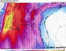
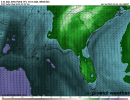
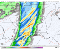
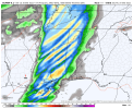
That's going to be a legitimate concern. The troughing we have over the East this weekend pushes the deeper moisture south. We recover lowest-level moisture QUICKLY across the Gulf, but the first push or two inland is not going to be that deep. That's going to mean there will be mixing in the warm sector during the daytime. We do get a last minute surge of boundary layer moisture that extends up to or above 850mb right ahead of the QLCS, because we get deeper moisture to surge north out of the Caribbean into the Gulf at the same time the more shallow initial moisture return surges inland from the Gulf Tuesday into Wednesday, but yes, there will be mixing in the warm sector until the final surge of moisture just ahead of the QLCS. The Euro, UKMET, and Canadian may be overdoing it, but you may see dewpoints drop out of the 60s into the 50s Wednesday morning before the surge just ahead of the QLCS gets them back into the 62-66 range.