CheeselandSkies
Member
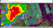
That tells the story...even with a functional GRK, the storms are too far away now to show the impressive velocities.
Follow along with the video below to see how to install our site as a web app on your home screen.
Note: This feature may not be available in some browsers.

00z HRRR soundings get flat 1000 SBCAPE up into the Shoals ahead of that QLCS with just 62-63 dewpoints. But yeah, farther south/southwest where the dewpoints are in the mid to upper 60s, whew...Gonna be watching moisture advection like a hawk; if those 65+s dews keep creeping closer it could be a long day

View attachment 12726
Based on everything I've seen so far today into this evening, if I was the SPC forecaster on duty tonight, this is what would be coming across the wire at 06z. You can't ignore the multi-model signal for the discrete long-trackers to be along and east of I-55, and you also can't ignore the blatant trend for adequate instability to get up into north MS/AL ahead of that QLCS.
It started becoming evident that surface winds would be more SSE than sharp SE to ESE. That allows better moisture advection farther to the north.Wow Fred, you sure changed your tune on this one (not knockin' ya, it happens)!
your contributions here cannot be overstated. very much appreciate your perspectiveIt started becoming evident that surface winds would be more SSE than sharp SE to ESE. That allows better moisture advection farther to the north.


Both cells in vicinity showing strengthening and organizing rotation in vicinity, unsurprisinglyVAD from Shreveport still very supportive of tornadoes, something to watch as those cells near SHV.
View attachment 12730