TornadoFan
Member
We got GRK back.
Follow along with the video below to see how to install our site as a web app on your home screen.
Note: This feature may not be available in some browsers.
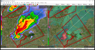
It just went TORR.Southern most tornadic supercell could eventually be an issue for College Station/Bryan if it holds together. Looks pretty impressive.
DISCUSSION...A QLCS is maturing across northern Texas per latest
MRMS mosaic radar imagery. Meanwhile, at least 4 supercells with a
history of producing tornadoes are ongoing across central Texas.
Storms within both regimes are impinging on the western fringes of
the low-level jet and associated strong low-level shear, which is
likely supporting the relatively robust tornado production that has
been observed over the past few hours. A moist, buoyant
thermodynamic profile is accompanying the low-level jet per 23Z
mesoanalysis, with over 2000 J/kg MLCAPE residing ahead of both the
supercells and QLCS.
Damaging winds and isolated tornado potential should continue with
the QLCS through the remainder of the evening, including in areas
east of the ongoing watch (please see Mesoscale Discussion #0296 for
more details). Farther south, supercells are remaining discrete and
are continuing in a favorable CAPE/shear environment for continued
tornado production. It is possible that the Pacific front/dryline to
the immediate west may catch up to the storms. In this case, the
supercells may grow upscale into an MCS similar to what has happened
farther north. However, Warn-on-Forecast high-resolution ensemble
guidance suggests that supercells may remain discrete through 02Z.
The best corridor for tornadic supercells may be from Falls/Lee
County and points northeast, as storms farther to the south may be
struggling due to weaker flow in the 850-700 mb layer.
ugh the presentation of these supercells is classic and terrifying

velocity on it looks really poor at the moment, but it could be cyclingShould College Station be worried? That Caldwell tor warned storm has a massive hook on it.