- Thread starter
- Moderator
- #221
Ugh looks like we lost a radar to a tornado.
Follow along with the video below to see how to install our site as a web app on your home screen.
Note: This feature may not be available in some browsers.


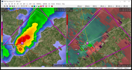
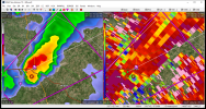
Jeff Mangum is showing damage. The sun is out behind this line and it is vert muggy. I don't know if this cluster of storms is moving east and we are in the clear west of I-35 our there might be more development.TDS was scanned at under 300' off the ground at 2320 UTC. That was likely sayonara for KGRK.
Storm Prediction Center Mesoscale Discussion 295
Severe weather, tornado, thunderstorm, fire weather, storm report, tornado watch, severe thunderstorm watch, mesoscale discussion, convective outlook products from the Storm Prediction Center.www.spc.noaa.gov
DISCUSSION...Multiple supercells, thunderstorm clusters, and linear
segments have developed across the western portions of Tornado Watch
#054 over the past couple of hours, with a history of tornadoes near
Jacksboro and Bowie Texas. Storms continue to develop ahead of a
Pacific front/dryline just west of the I-35 corridor, and are
advancing east into a buoyant airmass. These storms are also
progressing toward the axis of the low-level jet, where greater
moisture and low-level shear exist (per 22z mesoanalysis). 20Z RAP
forecast soundings (valid for 22-00Z) show large, curved hodographs
downshear of the ongoing storms). As such, tornado potential is
expected to increase through the remainder of the afternoon into the
evening hours.
Of particular concern are the supercells along a line from Burnet to
Guadalupe Counties, which are tracking in an thermodynamic
environment characterized by 2000+ J/kg MLCAPE. Given the storm mode
and aforementioned buoyancy/shear, a heightened tornado threat may
develop. Any supercell that becomes dominant/discrete (relatively
pristine inflow) will have the greatest risk for producing strong
tornadoes, and a long-lived, long-tracked tornado cannot be
completely ruled out.
Jeff Piotrowski says there's still a large tornado on the storm that took out the Granger radar.
The NWS there has available to it the TAMU S-Band radar data in real-time.
None that I am aware of. Unlike the NEXRADs, it is a privately owned university radar. I know a few universities make their radar raw data public, but the majority don't.Do you know of any public access to the radar data from that site?
PDS just added on this stormElgin, TX is in a world of hurt.