• Welcome to TalkWeather!
    We see you lurking around TalkWeather! Take the extra step and join us today to view attachments, see less ads and maybe even join the discussion.
    CLICK TO JOIN TALKWEATHER

Late December Discussion

Kory

Member
Messages
4,928
Reaction score
2,119
Location
Tuscaloosa, Alabama
GFS op looks amazing. Meanwhile Euro isn't evening showing a disturbance. Nothing but a large dome of high pressure. GFS/CMC and to a lesser extent JMA all show a low just north of the GOM running east of the Appalachians, but ensembles GEFS, GEPS, EPS (plus Euro) favor the uneventful scenario. Hopeful we get some decent agreement soon.
Another year, another version of: King Euro vs. Inbred potato on steroids GFS.
We seem to keep getting back into this NW flow pattern. We had a brief shake up this past week, but the dominant overall pattern since November has been a NW flow. You can see how badly it is enhancing the drought across the Deep South and Plains.

The perpetual pattern shake up has been 2-3 weeks away and not moving forward.
 

rolltide_130

Member
Messages
828
Reaction score
378
Location
Harvest, Alabama
Special Affiliations
We seem to keep getting back into this NW flow pattern. We had a brief shake up this past week, but the dominant overall pattern since November has been a NW flow. You can see how badly it is enhancing the drought across the Deep South and Plains.

The perpetual pattern shake up has been 2-3 weeks away and not moving forward.

This is a classic Nina pattern we're in now. Really interested to see how this translates to spring.. the resemblance to December 2010 is uncanny..
 

Kory

Member
Messages
4,928
Reaction score
2,119
Location
Tuscaloosa, Alabama
Incredible arctic outbreak on the models for the New Year. Still some wavering on the northern and southern stream energy that will determine the amount of moisture available for wintry weather.

Looks brutal though...talking 25-35 degrees below normal for the Plains.
 

Kory

Member
Messages
4,928
Reaction score
2,119
Location
Tuscaloosa, Alabama
This is a pipe busting run for the eastern half of the U.S. Single digits and teens for the SE per the GFS for the New Year.
 

Kory

Member
Messages
4,928
Reaction score
2,119
Location
Tuscaloosa, Alabama
Don't be surprised if we squeeze out some wintry precip, mainly sleet, across the I-20/59 corridor in AL later tonight and tomorrow...accumulations should be minimal.
 

Daryl

Member
Messages
316
Reaction score
99
Location
Boaz,AL
Area Forecast Discussion
National Weather Service Huntsville AL
.LONG TERM...(Friday through Monday)
Issued at 405 AM CST Tue Dec 26 2017

By late Saturday night, a re-occurring theme continues with model
guidance differences. GFS guidance develops more forcing and allows
some decent moisture advection to occur from Texas into Arkansas and
Tennessee. Also, it develops mid/upper level forcing over the
Tennessee Valley westward into Oklahoma and Arkansas. The Canadian
is similar to GFS, but has the window of precipitation occurring
about 24 hours later (Sunday night into Monday). In contrast to both
of these models, ECMWF is much drier. It drives a stronger surface
high further southeastward by daybreak on Sunday (all the way down to
northern gulf coast states), effectively cutting off moisture
advection into the area much more quickly. Also, it keeps mid/upper
level forcing much further north. Given a bit more guidance leading
toward a wetter solution, will keep isolated to scattered precipitation
chances in the forecast Saturday night through Sunday night. Timing of
this precipitation could end up being about 24 ours off, closer to the
Canadian model. With such cold and dry air in place during either of
these periods, much of this precipitation looks to fall in the form of
light snow. A few inches look possible, with maybe as much as 3 to 5
inches in our southernmost counties.

As most models push a strong cold front through the region Monday
morning, our first true arctic air pushes into the Tennessee
Valley. Highs in the lower 30s look like a good possibility (this
may be generous) with lows it the teens for sure Monday through
Tuesday night. If we do see the afore-mentioned snowfall over the
weekend or Monday, temperatures might only make it into the teens or
lower 20s on Monday (with lows in the single digits) due to snowpack
effects and lingering cloud cover.
 

ghost

Member
PerryW Project Supporter
Messages
1,004
Reaction score
352
Location
NW AL
Latest GFS has single digits Tuesday morning Jan 2 and 6" snow IMBY!
 

Mike S

Administrator
Staff member
Administrator
Moderator
PerryW Project Supporter
Messages
1,991
Reaction score
1,115
Location
Meridianville, Al
Special Affiliations
  1. SKYWARN® Volunteer
Latest GFS has single digits Tuesday morning Jan 2 and 6" snow IMBY!

I'll take it. That will result in an Arsenal closure and an extra day off!
 

rolltide_130

Member
Messages
828
Reaction score
378
Location
Harvest, Alabama
Special Affiliations
The stark differences between the Euro and other guidance over the next week is truly incredible.

Euro seems like it wants to prime us for a more active severe pattern post-240.. starting to see that AK trough, EPAC ridge, West Coast trough pattern start building..
 

Kory

Member
Messages
4,928
Reaction score
2,119
Location
Tuscaloosa, Alabama
Euro seems like it wants to prime us for a more active severe pattern post-240.. starting to see that AK trough, EPAC ridge, West Coast trough pattern start building..
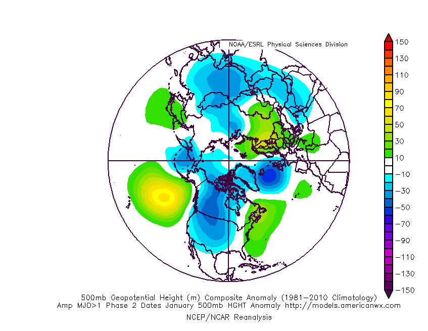
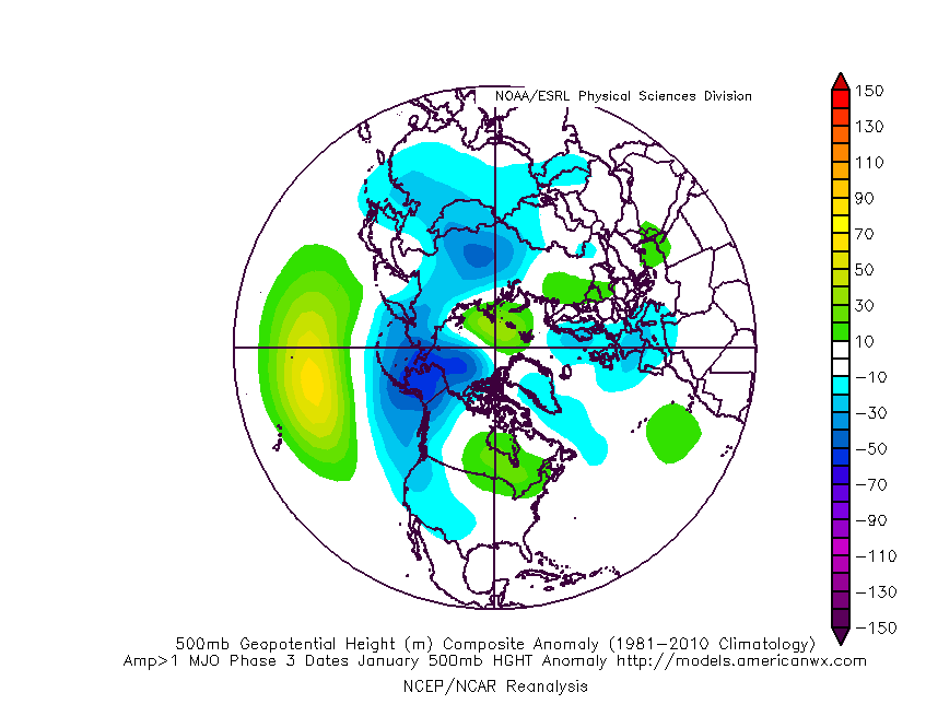
Would fit both MJO (phase 2/3) and GWO (phase 1/2) progression. Although, I think it is a bit rushed and would likely be the 2-3 week period though. That is the more potentially active severe period. But that's way out there.

Phase 2 MJO in January. Sig troughing over the West/Central U.S. with subtle ridging over the East Coast.
JanuaryPhase2gt1500mb.gif


JanuaryPhase3gt1500mb.gif
 

rolltide_130

Member
Messages
828
Reaction score
378
Location
Harvest, Alabama
Special Affiliations
There is a slow warming trend regarding the brutally cold temps on the GFS.

It wouldn't be the first time this winter. We've seen it moderate to seasonably cool every time so far. I'm getting a growing feeling it's going to cave completely to the Euro by the time we get to New Years Eve..
 
  • Like
Reactions: KoD
  • Thread starter
  • Moderator
  • #34

KoD

Moderator
Staff member
Moderator
PerryW Project Supporter
Messages
1,380
Reaction score
697
Location
Huntsville, AL
CMC now trends more towards the Euro. I'm hopeful but not optimistic on the GFS solution for precipitation. While the GFS is somewhat mildly consistent, The Euro is too in its depiction of an entirely different setup.
 

Kory

Member
Messages
4,928
Reaction score
2,119
Location
Tuscaloosa, Alabama
CMC now trends more towards the Euro. I'm hopeful but not optimistic on the GFS solution for precipitation. While the GFS is somewhat mildly consistent, The Euro is too in its depiction of an entirely different setup.
GFS has been going that way precip wise for a while now. While still a respectable arctic outbreak, it has been slowly, but surely moderating....the 00z is no different.
 
  • Thread starter
  • Moderator
  • #36

KoD

Moderator
Staff member
Moderator
PerryW Project Supporter
Messages
1,380
Reaction score
697
Location
Huntsville, AL
GFS has been going that way precip wise for a while now. While still a respectable arctic outbreak, it has been slowly, but surely moderating....the 00z is no different.
Indeed the 00Z GFS caves big toward the euro. Much more realistic temperatures too. Cold no doubt, and plenty windy, but not the -2F in Florence/HSV stuff.
 

Kory

Member
Messages
4,928
Reaction score
2,119
Location
Tuscaloosa, Alabama
Will be interesting how the models resolve the tail end vort max on the trough. The CMC crashes that thing toward the Gulf Coast opening the door for some New Year's Day snow along the coast. Not the solution I want being in NOLA for the Sugar Bowl.

GFS could be headed that way too. In this case, the cold air would already be established. We'd just be waiting on a precip trigger.
 
  • Thread starter
  • Moderator
  • #40

KoD

Moderator
Staff member
Moderator
PerryW Project Supporter
Messages
1,380
Reaction score
697
Location
Huntsville, AL
And the Euro caves! Wow.

Still not as brutally cold as the GFS but it's a respectable arctic outbreak.
:eek:


gfs_T2m_us_34.png

Pretty heavy duty arctic air
 
Last edited:
Back
Top