• Welcome to TalkWeather!
    We see you lurking around TalkWeather! Take the extra step and join us today to view attachments, see less ads and maybe even join the discussion.
    CLICK TO JOIN TALKWEATHER

Late December Discussion

KoD

Moderator
Staff member
Moderator
PerryW Project Supporter
Sustaining Member
Messages
1,405
Reaction score
761
Location
Huntsville, AL
GFS is taunting us in the long range with a couple systems around Christmas. Of course, the only things that's consistent is the inconsistency ... But nonetheless we can discuss the potential here :cool:
 

Kory

Member
Messages
4,928
Reaction score
2,120
Location
Tuscaloosa, Alabama
Major pattern shake up for day 7 and beyond. Sig troughing drops into the west and SE ridge makes an appearance. Warmer than what we've been dealing with, but I'd expect an active storm track.
 

rolltide_130

Member
Messages
828
Reaction score
379
Location
Harvest, Alabama
Special Affiliations
Major pattern shake up for day 7 and beyond. Sig troughing drops into the west and SE ridge makes an appearance. Warmer than what we've been dealing with, but I'd expect an active storm track.

Depending on how much this ridge pumps itself up and how that cutoff over the US/Mexico border behaves, this could be a potentially active severe pattern we're dealing with here
 

MichelleH

Moderator
Moderator
Messages
1,018
Reaction score
1,731
Location
Cullman, AL
From this morning's AFD from Birmingham NWS. Just something to watch.

There are still some key differences regarding the strength of the
low and associated backing of the low-level winds, and how soon
the low-level winds will veer out relative to the instability
arriving. If trends continue, a threat for isolated tornadoes late
Tuesday night and Wednesday morning could be added to the HWO in
later issuances given favorable wind profiles for mini-supercells.
 

MichelleH

Moderator
Moderator
Messages
1,018
Reaction score
1,731
Location
Cullman, AL
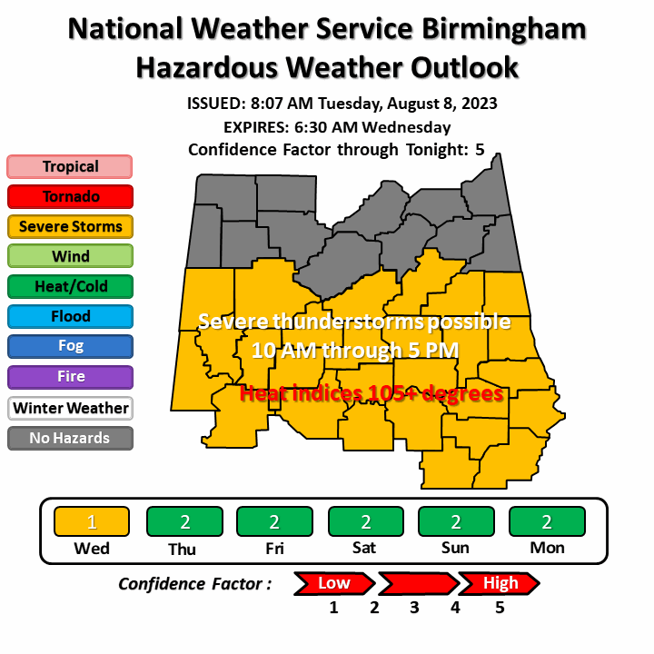
From this morning's HWO from BMX:

http://www.weather.gov/bmx/hwo

There is a marginal risk of severe storms late Tuesday night and
Wednesday morning across much of Central Alabama. A brief tornado or
two and isolated damaging wind gusts up to 60 mph will be possible
between 3 AM and noon on Wednesday.


HWO.gif
 

rolltide_130

Member
Messages
828
Reaction score
379
Location
Harvest, Alabama
Special Affiliations
I heard the opposite that it will be chilly and possibly snow showers in Tennessee on Christmas Day.

The pattern is so dynamic right now that it is absolutely impossible to make any sort of call. We could be looking at a potential 30-40 degree temperature swing based on where the front is on Christmas Day. All modes of weather: Blisteringly cold, mild and warm, winter weather, and severe weather all on the table.
 

Richardjacks

Member
Meteorologist
Messages
1,161
Reaction score
1,331
Location
Atop Red Mountain Birmingham, Al
The pattern is so dynamic right now that it is absolutely impossible to make any sort of call. We could be looking at a potential 30-40 degree temperature swing based on where the front is on Christmas Day. All modes of weather: Blisteringly cold, mild and warm, winter weather, and severe weather all on the table.
Dynamic for sure, but I am about to bite into the cold solution with a chance of snow for Alabama. While I would like to see the Euro come on board, it does seem to be leaning that direction. I do believe the cold may be transient and not hang around for very long, but it is these kind of patterns that typically produce the highest risk of winter wx in the southeast. Cold air without extreme moisture suppression and signs of an active subtropical jet seem to be the general idea. I will say that I would like to see the band of precip shown on the GFS to be a little further south, because no doubt there will be adjustments, and probably north.
 
  • Thread starter
  • Moderator
  • #10

KoD

Moderator
Staff member
Moderator
PerryW Project Supporter
Sustaining Member
Messages
1,405
Reaction score
761
Location
Huntsville, AL
Major inconsistency continues... Severe potential looks fairly minimal, and winter wx also appears mediocre. However I hope the #NWtrend holds for the moisture and not the 540.
 

Daryl

Member
Messages
316
Reaction score
99
Location
Boaz,AL
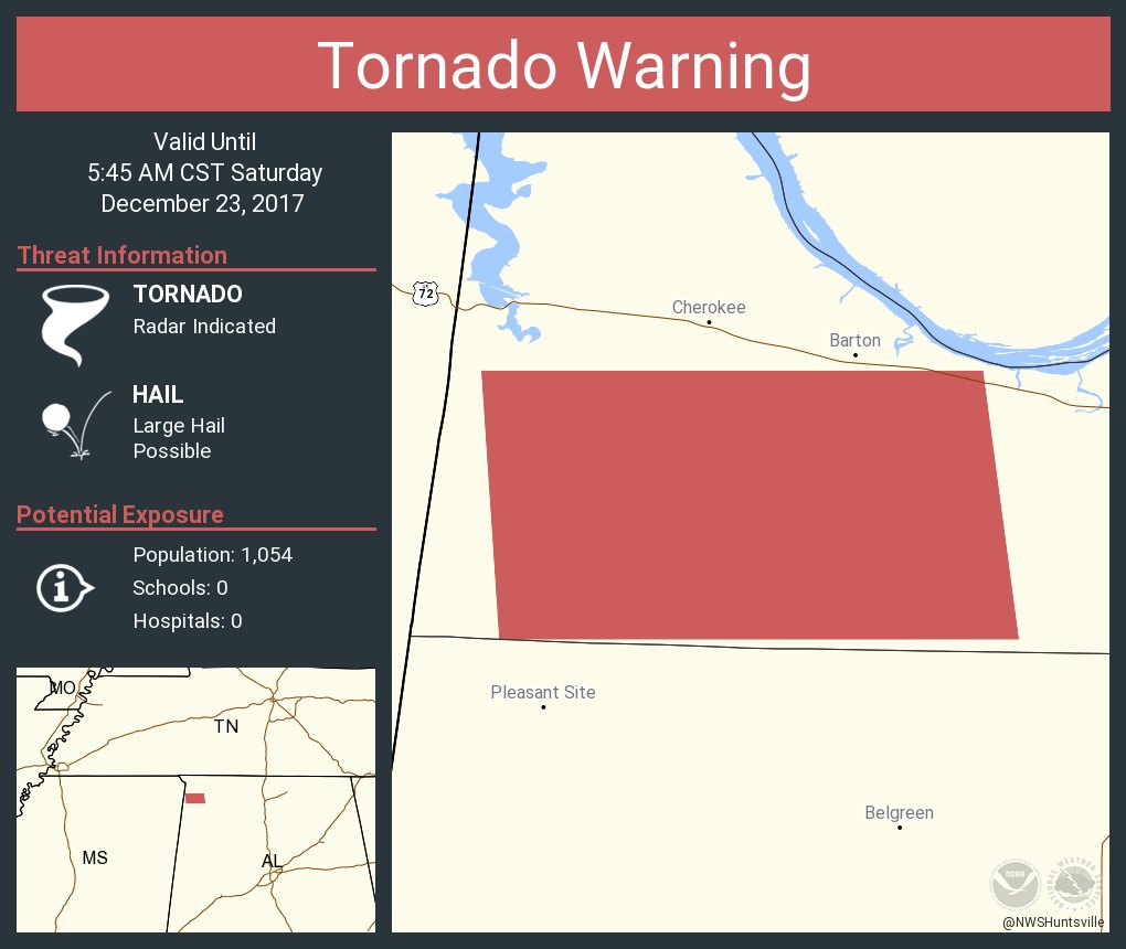
BULLETIN - EAS ACTIVATION REQUESTED
Tornado Warning
National Weather Service Huntsville AL
517 AM CST SAT DEC 23 2017

The National Weather Service in Huntsville Alabama has issued a

* Tornado Warning for...
Southwestern Colbert County in northwestern Alabama...

* Until 545 AM CST

* At 517 AM CST, severe thunderstorms capable of producing both
tornadoes and extensive straight line wind damage were located 7
miles south of Cherokee, or 10 miles east of Tishomingo State Park,
moving east at 35 mph.

HAZARD...Tornado.

SOURCE...Radar indicated rotation.

IMPACT...Flying debris will be dangerous to those caught without
shelter. Mobile homes will be damaged or destroyed.
Damage to roofs, windows, and vehicles will occur. Tree
damage is likely.

* This tornadic thunderstorm will remain over mainly rural areas of
southwestern Colbert County, including the following locations: Red
Rock, Posey Loop, Mynot, Mt Hester and Srygley Church.
 
  • Thread starter
  • Moderator
  • #13

KoD

Moderator
Staff member
Moderator
PerryW Project Supporter
Sustaining Member
Messages
1,405
Reaction score
761
Location
Huntsville, AL
Looks like KHTX is down, it hasn't been a good year for that fella.
 

Mike S

Administrator
Staff member
Administrator
Moderator
PerryW Project Supporter
Messages
2,050
Reaction score
1,233
Location
Meridianville, Al
Special Affiliations
  1. SKYWARN® Volunteer
I really like this graphic. It is extremely easy to understand and gives you all the pertinent information.

DRuiu1JX4AAEqi8.jpg:large
 
  • Like
Reactions: KoD

StormStalker

Moderator
Staff member
Moderator
Messages
576
Reaction score
478
Location
Tuscumbia, AL
Special Affiliations
  1. SKYWARN® Volunteer
It woke me up this morning and I agree that is a great graphic.
 

Kory

Member
Messages
4,928
Reaction score
2,120
Location
Tuscaloosa, Alabama
A few wintry weather events possible over the next 2 weeks. One of note is around New Year's. Ice storm for NOLA in time for the Sugar Bowl per the GFS. :p
 
  • Thread starter
  • Moderator
  • #18

KoD

Moderator
Staff member
Moderator
PerryW Project Supporter
Sustaining Member
Messages
1,405
Reaction score
761
Location
Huntsville, AL
A few wintry weather events possible over the next 2 weeks. One of note is around New Year's. Ice storm for NOLA in time for the Sugar Bowl per the GFS. :p
GFS op looks amazing. Meanwhile Euro isn't evening showing a disturbance. Nothing but a large dome of high pressure. GFS/CMC and to a lesser extent JMA all show a low just north of the GOM running east of the Appalachians, but ensembles GEFS, GEPS, EPS (plus Euro) favor the uneventful scenario. Hopeful we get some decent agreement soon.
Another year, another version of: King Euro vs. Inbred potato on steroids GFS.
 

MattW

Member
Messages
325
Reaction score
228
Location
Decatur, GA
HAM Callsign
KG4GUF
Special Affiliations
  1. SKYWARN® Volunteer
Key question is, who handled the early December surprise better this far out? Euro or GFS?
 
  • Like
Reactions: KoD
Logo 468x120
Back
Top