N
Not here anymore
Guest
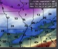
06Z GFS run. This is the 2nd run of these incredible snow accumalations.

Follow along with the video below to see how to install our site as a web app on your home screen.
Note: This feature may not be available in some browsers.
Honestly it's too early for totals I'd wait for a few days. And I'm not sure honestly, I'm more of a amateur, I think there's more knowledgeable people on the forumn that could better answer that question. Im still learning x.xIm in Senoia Ga, latest runs are leaning more towards crippling ice where Im at. Showed historic amounts of snow when I checked models the last 2 days. Im curious your thoughts on how this will play out for my area. I dont have in depth access to these models, I just pay attention to Pivotal, tidbits, nws and have a basic weatherbell plan. Why does tidbits GFS always show drastically higher 10:1 snowfall than other sites? Thanks for your input!
The key to this forecast is the depth of the cold air (sub freezing). If it’s deep enough, it will be snow or more likely sleet with a lot less power outages but still hazardous roads. The process for freezing rain is very complicated when the temps are close to freezing near the ground. As the rain freezes, latent heat is released which could cause the temps to rise a degree or two, but as it melts, heat is absorbed possibly causing the temps to drop again. In near/close margin situations freezing rain and ice secretion are complicated processes and difficult to forecast and can change quickly based on rain intensity and cold air advection near the ground.
Also this looks like a strictly overrunning event with no instability or convective elements. I remember an example or two when there was some lightening/convection and mixing where some of the warmer air aloft was actually mixed down causing near ground temps to temporarily warm melting some of the ice, improving conditions, that doesn’t seem to be the case since it’s all overrunning/isentropic lift.
If there is a silver lining to the event, at least temperatures will be in the 50s before the system arrives.
As someone who has lived through two crippling ice storms, I'll take sleet or sn anyday of the week and twice on Sunday.The key to this forecast is the depth of the cold air (sub freezing). If it’s deep enough, it will be snow or more likely sleet with a lot less power outages but still hazardous roads. The process for freezing rain is very complicated when the temps are close to freezing near the ground. As the rain freezes, latent heat is released which could cause the temps to rise a degree or two, but as it melts, heat is absorbed possibly causing the temps to drop again. In near/close margin situations freezing rain and ice secretion are complicated processes and difficult to forecast and can change quickly based on rain intensity and cold air advection near the ground.
Also this looks like a strictly overrunning event with no instability or convective elements. I remember an example or two when there was some lightening/convection and mixing where some of the warmer air aloft was actually mixed down causing near ground temps to temporarily warm melting some of the ice, improving conditions, that doesn’t seem to be the case since it’s all overrunning/isentropic lift.
.png")

.png")
.png")
That Baron model is nuts. I can’t even picture what 12-18” of snow would look like
I remember it a little as I was 5 years old. Most of my memories from it include the sledding and being stuck at home for a while. I don't really remember or understood the other impacts.I can. I remember March '93 very well.
It was a historic and bad enough event that at least once in every winter storm in the south, someone brings it up and asks if "this one will be as bad as March 93". LOL. I was 21. We were without power for 10 days with no heat and only a Coleman camping stove to cook on. It was a life threatening and miserable event that I hope no one ever has to go through again.I remember it a little as I was 5 years old. Most of my memories from it include the sledding and being stuck at home for a while. I don't really remember or understood the other impacts.
I'd say they both trended colder.Euro and GFS have almost completely flipped for snow totals in N MS, AL, and GA. (I'm using College of Dupage's website, since I'm not on my home computer currently).
Not sure I believe the Euro's depiction; Assuming that it's just a bad run. Would love to hear ya'lls take on it, though.
Euro (06z Yesterday is on top, recent 06z is below.
GFS
(06z Yesterday is above, recent 06z is below)
Main difference is depth of sub freezing temps which will dictate precipitation type. I will say in this kind of setup I would expect to see colder air aloft but it depends on eventual track of surface low, if it’s further to the south, the cold air won’t be as shallow and there will be more snow.I'd say they both trended colder.
93 was rough! I got all gas appliances in my new house after the 93 storm.It was a historic and bad enough event that at least once in every winter storm in the south, someone brings it up and asks if "this one will be as bad as March 93". LOL. I was 21. We were without power for 10 days with no heat and only a Coleman camping stove to cook on. It was a life threatening and miserable event that I hope no one ever has to go through again.