• Welcome to TalkWeather!
    We see you lurking around TalkWeather! Take the extra step and join us today to view attachments, see less ads and maybe even join the discussion.
    CLICK TO JOIN TALKWEATHER

Severe WX January 10-12, 2020 Severe Weather Forecast Thread

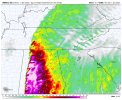
0z HRRR also continues to show conditions volatile NE of Metro Atlanta at 0z Sun. Yet the local NWS office shows this for the forecast that regular folks see... Showers ????? Guess they see overriding factors that I don't see.
View attachment 2371
View attachment 2372
View attachment 2373

Weak CAPE (not in itself a deal-breaker), but also some capping and mediocre lapse rates. Updrafts would probably get ripped apart by that speed shear before they can become established.
 
Weak CAPE (not in itself a deal-breaker), but also some capping and mediocre lapse rates. Updrafts would probably get ripped apart by that speed shear before they can become established.

I thought the STP took CAPE and the cap into account as part of the algorithm, as well as a number of other sheer factors.
 
Can anyone give me a round-about tor con for the Jackson, TN area?

I think you're better off getting tor:con from the weather channel. Many users here find it too vague to be useful. In fact we used to have a thread all about it and it often comes up every big event. Some like it, some don't. Stick with SPC parameters and forget about tor:con or we're going to get a whole big thing going ;). I'll give you a 5 to humor you though. Not that it means much.
 
Seems to be a split on the HRRR vs the NAM 3km for Atlanta. HRRR keeps a tornado threat, the NAM is a bit quieter, but still showing some tornado potential.
 
From the Perry Memorial Weather Station, the Temperature is currently 63.5 with a dewpoint of 62. Today's High was 64.6. Max wind gust so far is at 25.1 mph ESE. 0 inches of rainfall at this time.
 
Seems to be a split on the HRRR vs the NAM 3km for Atlanta. HRRR keeps a tornado threat, the NAM is a bit quieter, but still showing some tornado potential.

One difference in the models is the projected dewpoints. HRRR is higher, so that may be part of the difference. I haven't gone back to compare what was forecasted today vs the actuals. Not sure which model may be better on that parameter.

1578715371500.png

1578715405146.png
 
Something to note is that HRRR is running a couple of degrees cool on surface temps, esp over Alabama. With as cold as the upper levels are, a difference of a couple degrees could make a fairly large impact.

al.sfc.gif
sfct.us_se.png
 
Back
Top