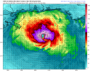
Dat tail though... 
Follow along with the video below to see how to install our site as a web app on your home screen.
Note: This feature may not be available in some browsers.

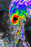
Wow, that is impressive. For those for educated than me, does that mean it's pulling in some moisture for the Caribbean?
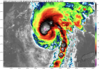
Not exactly - it doesn't exactly feed on it - when a hurricane's outflow channel meets an upper low (there's one in the Caribbean), the two flows can set up a narrow axis of confluence and diffluence aloft, and deep convection fires along it. That gives a thin line of cold tops like the one in the image. You can watch it happen on this upper level WV loop.Wow, that is impressive. For those for educated than me, does that mean it's pulling in some moisture for the Caribbean?
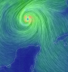

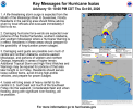



I am now located in the path of the eye...yay . Hoping it will move further east.
It's (unfortunately) trying its best!I'm normally one to appreciate the beauty of storms, but Isaias is not very photogenic. This is a gnarly looking beast, bearing their teeth right now in the face of wind shear. The string of cells on the SE band are crazy too. Ugly storm that will probably bring ugly impacts...
View attachment 55218
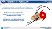
just saw a write up by Al.com I think that there’s some worry of a sting jet setting up somewhere over Alabama tommorw
Looks more like a derecho rather than a hurricane.I'm normally one to appreciate the beauty of storms, but Isaias is not very photogenic. This is a gnarly looking beast, bearing their teeth right now in the face of wind shear. The string of cells on the SE band are crazy too. Ugly storm that will probably bring ugly impacts...
View attachment 55218

I cast tornadoI'm normally one to appreciate the beauty of storms, but Isaias is not very photogenic. This is a gnarly looking beast, bearing their teeth right now in the face of wind shear. The string of cells on the SE band are crazy too. Ugly storm that will probably bring ugly impacts...
View attachment 55218