• Welcome to TalkWeather!
    We see you lurking around TalkWeather! Take the extra step and join us today to view attachments, see less ads and maybe even join the discussion.
    CLICK TO JOIN TALKWEATHER

Iceland's Fagradalsfjall Fires

IMO says the eruption is over. Landrise still continues, though.

And old lava still flows. Here is RUV's update (autotranslated):

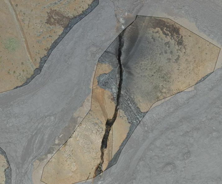
Try to cover the lava tongue with soil​

The contractors at Sýlingarfell plan to try to stop the progress of the lava over the rampart by pouring soil into the opening.​

Thorgils Jonsson
June 22, 2024 at 15:19 GMT,updated at 15:56
A
A
A
Machines work to slow the lava's progress with earthen dams and cooling water.

The contractors are working their way up to the lava line and are going to try to stem the flow by pushing material on top of the opening.
RÚV – Ragnar Visage
The contractors at the Sýlingarfell dike are now preparing an attempt to stop the lava flow that runs over the dike by pushing soil on top of the opening...

Also, yesterday there was an announcement that two boreholes on the peninsula where Keflavik Airport and the old US military base are located can supply at least survival-level geothermal backup in case the Svartsengi plant goes down -- only double-digit (°C) sources, compared with Svartsengi's robust triple-digit heat source, but it's something.
 
I'm passing along a sizable quote from this RUV story (autotranslated) not only to share an image of someone who looks exactly like my mental image of a Viking (in modern clothes, and one of his names is Thor) but also because of the part I added emphasis to -- Iceland has already changed the world of lava diversion forever with these Grindavik, Svartsengi, and Hraun (remember little Hraun?) barriers -- what they are doing now is cutting-edge stuff, and as this geologist says, the world is with them:

The eruption at Sundhnúk is over, according to scientists. Work groups have mostly managed to stop lava flows that flooded the defense wall at Sýlingarfell.​

Hólmfríður Dagný Friðjónsdóttir
June 22, 2024 at 21:10 GMT
A
A
A
Machines work to slow the lava's progress with earthen dams and cooling water.

One lava flow flowed over the park today.
RÚV – Ragnar Visage

Day and night, the contractors at the defense wall at Sýlingarfell have fought against the tide, literally. When the newsroom was traveling today, lava was still flowing over the garden in one place.

"This is a good thing. We are raising the garden and widening it and are preparing to make an attempt to stop this tongue here; suffocate it with soil," says Jónas Þór Ingólfsson, a geologist at Efla.

Jónas Þór Ingólfsson, geologist at Efla

Jónas Þór Ingólfsson, geologist at Efla.
Viðir Holm

...

"This is an experimental activity. It wasn't like we sat down and googled it. There is nothing like that about this," says Sverrir Haukur.

"There are many people who came to this and are thinking this. Circumstances arose where it was decided to try this. And at least we're still cooling," he adds...

I am not sure how the gravel and "suffocating" are supposed to work -- perhaps the gravel enlarges the amount of water surface in contact with the lava, increasing the amount of heat transferred?

I'll just leave this here (source, CC BY) -- the authentic helmets don't have horns...

8848.jpg.webp
 
Just came across this video posted ten hours ago by Just Icelandic --


-- and also came across tweets from non-geoscientists noting that the soil weight compresses the lava (everything is basalt on the peninsula, so basic density difference isn't much of a factor). Wetting it down increases the mass -- same reason why ash will collapse roofs if it gets wet...very porous stuff.
 
They've done an amazing job with controlling the flow; a well-fought battle but I think it would be wise for them to be planning to lose the war as it's bound to overwhelm them sooner or later. Ask the Dutch about controlling mother nature's forces and they will tell you it's never a 100% certain thing even with constant work and upgrades.
 
I used to think so, too, but apparently the Icelanders aren't familiar with the concept. ;)

Current cam image:

screenshot_20240623-172101_youtube.jpg


Squeezing lava...who would have thought of it? A lot of volcanologists and engineers are having trouble believing it, too, but there it is.

Everyone knows that this is only for the short term, and they got a big break with the amazingly sudden end of the eruption. But they tried something that has never been tried before and, to this small extent alone, it worked.

As for the plant, yeah. They very well could lose it in this series or some future series and they are making options for themselves. I don't understand why they don't work in** the other high-temp geothermal field in the area, called "Reykjanes," on the tip of the peninsula (technically, I think, the plant/Blue Lagoon complex is working the "Svartsengi/Eldvorp" geothermal area).

That screenshot is through the mbl.is Thorbjorn close-up cam from just a few minutes ago, but Visir reports that mbl.is website got hacked big time and as of right now is still offline -- that's why some links in this thread and at the blog might not be working. RUV and Visir thus far are good.

** Edit: I mean "combine" -- HS Orka is exploiting both fields and has a plant on each one (with the Reykjanes geothermal plant opening in, I think, 2006).
 
Last edited:
Got on X and saw this -- translation: "A large-scale cyber attack has been carried out on Árvakur's computer system. It appears that a Russian criminal organization of hackers is behind the attack.The attack occurred at noon today. As a result, a decision was made to turn off Árvakur's systems."

 
This is ~SE of Reykjavik and tens of miles ~NE of Svartsengi and the active fissure area. The circles are large only because of map scale and lack of any really strong events then -- M3 is moderate, at most, and reportedly (IMO) these weren't felt.


Here's the relvant part of a blog post on that, the mbl.is hack, and that question about backup for the power plant:

...
The current IMO geoscientist note mentions the larger ones and points out that the last one here of such magnitude was back in 2021.

The Brennisteinfjoll (Blafjoll) system does kick up now and then, and is reportedly the source of highest seismic hazard to Reykjavik.

In recent months, spokespeople have noted that IMO has found no evidence of magma movement causing the quakes there, but let’s see if they address that again in updates or interviews.

Speaking of interviews, mbl.is was hacked (autotranslated) big time yesterday; apparently the site is up now in Iceland, but I still can’t access it.

Finally, I had been wondering why they’re going with low-temp fields near Keflavik for backup in case they lose Svartsengi geothermal supply when there is an even higher-temp geothermal field than Svartsengi just to the west, called Reykjanes, at the tip of the peninsula.

Why not just fall back on that one? HS Orka, I understand, operates both and it’s not very far away, as this screenshot of a figure in this paper (PDF download) shows:


The Reykjanes and Eldvorp-Svartsengi geothermal field locations. It’s still mind-boggling that what we’re looking at is the Mid-Atlantic Ridge, having risen some two miles from its usual location, coming ashore as dry land.


Then I saw that little rock to the left of the word “Reykjanes” and just off the coast.

That rock is called Eldey and AFAIK it is the only sign above sea level of the Eldey volcanic system.

The Eldey system has been having cycles of a few moderately strong seisms and less intense swarms, most recently a couple of weeks or so back.

IMO was concerned enough to go put a GPS station on that rock over the winter, though I haven’t come across any updates since. The folks at Volcano Cafe write of dike intrusions there, which could be going on though data collection must be extremely difficult.

Anyway, with Eldey active and so close to the Reykjanes geothermal source — even without factoring in the likely surtseyan explosiveness of any eruptions in either the Eldey or Reykjanes system (which extends offshore, too), I now see why they wouldn’t hitch their star to that wagon!

Surtsey, 1963 and 1964:

 
It isn't only lava that Icelanders will resist:

...Karl Blöndal, Morgunblaðin's assistant editor, says that paying a ransom for the data currently held hostage is not an option, but does not want to confirm whether such a demand has been received. "I don't want to go into it. The only thing I want to say is that these are naturally nasty and thugs," says Karl.

He says the cyberattack is Russian warfare, but adds that there was no data leak, but the data is being held hostage.

"They are coded and what we need to do is try to break that code."

-- Source (autotranslated)

If they succeed, a whole bunch of North American car dealership owners will be calling...

Edit, June 25: Not gonna get sidetracked from the Fires, but I did notice today that Iceland's prime minister and other top officials are talking serious stuff about Russia. Iceland is a founding NATO member, but it is talk for now -- Icelanders are obviously not going to let it go, though. Got most of that from mbl.is on Facebook, where you can read the headlines, at least, if you're not in Iceland. RUV is covering it, too. [Further update: And they've released Rat Julian Assange (Core reference)...hope he and his team can break the codes totally a coincidence, I'm sure; what possible help could people who can do and have done high-level hacking give? ] Now back to geology...
 
Last edited:
There was another 3-pointer in the Blafjoll area a little while ago. IMO mentioned it in a geoscientist note on their website but didn't elaborate. There is nothing on it yet in the online news sources I follow.

screenshot_20240625-105352_incognito-browser.jpg


It's such a complex geological situation, I'm not even going to try to speculate what, if anything, this moderately strong swarm might have to do with the Svartsengi sill and related eruptions.

That is Reykjavik, up in the left corner, so this story (autotranslated) on hazard there is worth reposting.

Granted, they're talking about a volcanic system called Krysuvik and these quakes are in the Brennisteinfjoll/Blafoll system, and I could also drag in a Fagradalsfjall-Krysuvik reference, which would then open up discussion of the Svartsengi sill, which is in a zone sometimes called Reykjanes/Svartsengi /Eldvorp... =8-O

No. The names of volcanic systems on this peninsula vary according to which expert you consult. IMO, I think, just recognizes two but no one is dogmatic and some experts see five or six!

And then there are the questions the petrologic findings on 2021-2024 lavas have opened up on the whole peninsula VS thing, anyway.

Sigh.

I don't think about names as much as proximity. These quakes in what some call the Blafjoll/Brennisteinfjoll system and the hazards of a system that some call Kryusuvik -- both are close to the capital, so they need watching, whatever happens elsewhere on the peninsula. That's all.
 
Geologically, things haven't changed much. Today an interesting paper was released, though (Thorvaldur and Armann are among the coauthors, and I'm proud to say the University of Oregon helped out [though in Corvallis, I'm usually all for Oregon State and do support the Beavers over Eugene's Ducks in football season]).

The paper is about modelling the type of magma reservoir(s) down there. It's not just academic because, as one author puts it in this video --


-- a single chamber under the whole peninsula, which is one possibility petrology suggests, could result in simultaneous eruptions in different places, which is something Iceland's decion-makers need to know about right now.

The boffins do not find that. Whew!

As best I can follow the video and the paper, which is not all the way, they don't agree with the idea of stuff coming directly up from the mantle, either -- this, I think, was the hypothesis that the team we saw sampling lava earlier in this thread came up with.

And I think their findings here are somewhat in disagreement with IMO's findings about the Svartsengi sill, its magma supply, and its connection to Fagradalsfjall -- but let's just leave that rabbit hole unexplored, since the debate continues.

Speaking of rabbit holes, this current paper mentions eight volcanic systems on the peninsula -- the main thing, though, is that they find a deep but still crustal magma chamber under Fagradalsfjall with two outlets, first to the 2021-2023 Fagradalsfjall vents and then to the sill under Svartsengi, (d, not e) here (CC BY-SA 4.0):

ter12733-fig-0003-m.png


That's also a diagram that Dr. Troll refers to a lot in the video.

Yes, there is a Dr. Troll studying Iceland. :)

Salt shaker: Not everyone agrees that what is causing mid-ocean ridge elevation and excessive magma production here is a plume (it's complicated), so the notion of horizontal magma flow under the peninsula from a central plume is still under discussion, too.

It gets supertechnical very quickly, but generally, I think, there are proponents of the more vertical intrusion, via dikes, from a magma body located at the crust/mantle boundary.

And the known more or less vertical big daddy on the Reykjanes Peninsula -- the plate boundary -- is all broken up into segments and torqued around (and does some torquing of its own, too!) so AFAIK eruptions in that model are unlikely to occur in different places at the same time. (That is my own conclusion from reading, though, and therefore inadequate, if not totally wrong.)

However, the seismic tomography in today's paper is very good evidence in support of their hypothesis.

ter12733-fig-0006-m.png


There's going to be much discussion among the boffins about this.

What does it mean for ordinary life?

Well, the likelihood of some sort of peninsular Ragnarok is diminished, so there's that. That's really big news, actually.

Thorvaldur last week, before the hack, told mbl.is that he thinks the deep magma supply might be getting low, which is good news, too, if correct.

And Armann reportedly still considers Eldvorp a possible future eruption site.

But like always, everyone must wait and see what happens next.
 
Last edited:
They spotted the increased sill inflation a few days ago, but IMO issued the official update today.

Via Google translation:

Landris in Svartsengi continues with increased speed​

New magma flows and/or eruptions are likely in the coming weeks​

28.6.2024


Updated June 28 at 11:55

  • The lava has an area of 9.3 km 2 and its volume is about 45 million m 3
  • The land ice in Svartsengi continues with increasing speed
  • Data collected in the coming days/weeks will help assess the situation with greater certainty
Seismic activity at Svartsengi and Sundhnúk is very low and few small earthquakes have been recorded in recent days. The lava moving towards the north side of Sýlingarfell continued to flow very slowly since the eruption ended on June 22 and has now completely stopped moving.

A team from the Institute of Natural Sciences and Land Survey of Iceland has processed data collected by experts from Efla, Verkís and Svarm during a drone flight over the eruption centers on June 24. The data shows that the lava is now 9.3 km 2 in area and the volume is about 45 million m 3 .


Hraunbreida28062024

A map showing the extent and thickness of the lava bed that has formed in the eruption that began on May 29. The map is the product of the collaboration of many parties, but is based on the measurements of Verkís, Efla and Svarma from June 24. The map shows where lava has collected in a lava pond southeast of Sýlingarfell (red area) and the lava stream that flows from there north of Sýlingarfell. Gray areas show lava that has flowed in the area since December 2023.

The latest deformation measurements (both GNSS and InSAR satellite images) show that the land rise under Svartsengi continues. The speed of the land increased after the eruption ended and is now greater than what was measured before the eruption that began on May 29. The rate of deformation can be interpreted as that magma inflow into the magma sphere at a depth of 4-5 km continues.


Bylgjuvixlmynd28062024
A wave interpolation image (InSAR) for the period 13 to 25 June shows that the deformation during this period is about 3-4 cm where it is greatest. The image is based on data from the Sentinel-1 satellite. Lava from Fagradalsfjall and Sundhnúks craters are marked with white outlines.

With these assumptions as a guide, it can be assumed that the system will behave in a similar way as before and that a new magma intrusion and/or eruption will occur again in the Sundhnúks area in the coming weeks. As of today, it is difficult to predict with certainty how the situation will develop. Data collected in the coming days/weeks will help assess the situation and possibly understand changes and trends within the magmatic system.


IMO also discussed (autotranslated) how to do an effective near-real-time polygon risk map for people in the area.
 
For the first time since they announced the eruption's end, IMO notes that earthquakes are occurring on the November 10 dike. They also describe other seismicity in the region, too, but nothing volcanic appears imminent right away.

Per Google translation,

Constant landris under Svartsengi for the last few days​


Magma flow continues under Svartsengi. Likelihood of another magma flow and/or eruption in the coming weeks and months​


9.7.2024


Updated July 9 at 11:15 a.m

  • Almost 20 earthquakes have been recorded over the magma tunnel, the largest one measuring 1.3 west of Grindavík.
  • More than 260 earthquakes have been recorded on the Reykjanes Peninsula in the past week.
  • Deformation data shows that landris is continuing at a similar rate in recent days
  • Risk assessment updated. Almost unchanged, but the risk of lava flows has decreased.

Almost 20 earthquakes have been recorded over the magma tunnel, the largest measuring 1.3 west of Grindavíkurbær. This is similar activity as has been the past two weeks.


More than 260 earthquakes have been recorded on the Reykjanes Peninsula in the past week. Around 60 earthquakes were recorded in Lambafell in Þrengslum. About a dozen in Brennsteinsfjöll. Over 100 earthquakes were recorded around Kleifarvatn, over 40 to the east of the lake and over 60 to the west and southwest of the lake at and around the geothermal area in Seltún. Just under 40 earthquakes were recorded in Fagradalsfjall, all below 1.0 in magnitude and most at a depth of 7 to 10 km. About 20 earthquakes were recorded outside Reykjanestá in the past week and another dozen earthquakes further out on the Reykjaneshrygg about 90 km southwest of the country.


GPS deformation data shows that landrising under Svartsengi continues and has been at a similar rate for the last few days. A Sentinel 1 satellite image spanning the period June 25 - July 7 shows the same pattern. Model calculations based on deformation data continue to indicate that magma influx is greater now than before the May 29 eruption. These data continue to indicate that another magma flow and/or eruption is likely in the coming weeks or months.


The risk assessment has been updated, and remains valid until July 16. It is mostly unchanged except that in Area 1 (Svartsengi) there is less danger due to lava flows. The risk is therefore reduced from considerable risk (orange) to some (yellow). Lava flow risk is also rated lower in Zone 6.

Haettusvaedi_VI_9juli_2024
(Click on the map to enlarge)
 
Still waiting; IMO reports that sill inflation continues, and they did express concern that the eruptions extend farther south and so it's not impossible that the next one, whenever it comes, might happen inside the Grindavik barriers.

Thorvaldur and Haraldur apparently disagree, per media reports, but IMO is standing by their statement.

Also, a story (autotranslated, link corrected) today in Visir explains why those explosions happened at the start of the last eruption and how lava was able to travel underground towards the barrier and also get close to the US naval antenna site:

...The Norwegian Meteorological Agency still expects a magma flow or eruption in the area in the coming weeks. The volume of accumulated magma is rapidly approaching the same level as before the last eruption.
"We're getting more tremors now day by day and clearly tension is building in the area."​

BF3535716692FB686DF7F3D54B8B8363AF5705CEBE324FC7E1912ABA8764DAA6_713x0.jpg
The fissure in Hagaféll seen from above from Landmæring Íslands' Umbrotasjá.

Expanded significantly in the last eruption​


Earthquake enthusiasts have today and yesterday drawn attention to a massive crack in Hagafell near the eruptions in the Earth History Friends group on Facebook. Jóhanna says the crack is not new, but it has certainly undergone a recent transformation.​

"But in the last eruption [29. May] it grew a lot and then lava started to flow into it and it's just a very big and huge crack. The lava that went into it came into contact with groundwater, and then these water explosions occurred as seen in the last eruption," says Jóhanna.​

The crack stretches south towards Grindavík and all the way to the defenses.​

"We have been watching her especially during the last eruption. It can be assumed that there is a certain extension of this crack that reaches even further south, and this is an example of the weaknesses in the crust that can be found there on the surface​
 
Last edited:
Got curious about Hagafell and ended up with this blog post; perhaps geonerds might be interested, but it also shows that the next eruption could be very disruptive:

July 22, 2024, 11:58 a.m., Pacific: This is one of those simple Icelandic geology things that are so complex when you get curious and delve into them a bit.


The simple fact: There is a big crack in Hagafell that is old but reportedly got bigger during the May 29th eruption and also allowed lava to interact with ground water — causing those spectacular initial phreatic explosions — and provided a subterranean pathway for some of the lava to get close to the Grindavik northern barrier, and farther west, to surface near the US naval communications station (without damage).


A simple video: Someone took a drone out yesterday and examined the crack:


Layperson speculation: The “smoke” is probably caused by ground water interacting weakly with lava that’s still hot.


Oh! The complexities! — I got curious about what Hagafell is and poked around Google Scholar a bit, coming up with a paper on the Sundukhnur crater row area published on 2009, long before the Reykjanes Peninsula began to wake up (moderate jargon alert).


As I understand it, Hagafell is basically a collection of pillow lava formed during submarine or subglacial eruptions.


It’s not a solid chunk of rock, in other words, so cracks likely would form in between some pillow layers.


BUT…


My general impression is that a complex set of forces from plate tectonics and Reykjanes Ridge interactions with the hotspot anomaly (which is a little farther east, under central Iceland) are calling the shots here.


Per the paper that goes with this abstract, there is a major change in the peninsula’s fracture orientation from 60° to 79° right here, just north of Grindavik.


All this, even before magma moved into the area underneath Svartsengi.


Now magmatic pressure is a stressor, too.


And because this is a mid-ocean ridge, not to mention the hotspot contribution, no one really knows for sure what the underground structure and plumbing are like.


Volcanologists really have their work cut out for them here!
 
Last edited:
Per the graphic (time dependent), there is a low-intensity but busy seismic swarm in the Eldey area ongoing just off the peninsula tip, but the current IMO geoscientist note (autotranslated) is:

The earthquake was this morning SW of Eldey on Reykjaneshrygg, the largest earthquake measured 3.2 in magnitude, but the weather office has not received reports that it was found in a settlement. Seismic activity in this area is frequent and traditional.

Volcanic activity in the Sundhnúks crater series. Landris is fairly stable and magma accumulation under Svartsengi continues, almost 16 million cubic meters of magma have accumulated there since the last eruption. 13-19 million cubic meters is the threshold considered sufficient to cause enough pressure to trigger a magma flow or eruption. According to according to the latest models, magma is flowing into the magma chamber at a rate of 4.4 cubic meters per second. Magma flow and then a possible eruption is likely in the next two to three weeks.

The risk assessment map has been updated, see more here.
Written by geoscientist on duty Jul 29 10:45 a.m
 
Looks like the new barrier arrangement protecting the power plant and Blue Lagoon might be tested soon.

And Grindavik...?

Again, such detailed forecasting is very unusual in volcanology -- the barriers are on the cutting edge of lava diversion studies, and the detailed work on this from IMO -- with a good track record thus far! -- is breaking new ground, too, especially the risk assessments.

Icelandic Meteorological Office


Screenshot from a surveillance camera at Hagafell taken at 7 July 26. The camera faces southeast. Steam rises from the crack outside Hagafell.

Increased probability of magma flow and even eruption in the coming days​

30.7.2024

Updated July 30 at 11:45 a.m

  • The number of earthquakes in the Sundhnúks crater series per day is slowly increasing
  • According to model calculations, enough pressure has built up in the system to trigger a new event in the coming days
  • GPS measurements show that the land giant has slowed down a bit in the last few days. The parallel seismic activity as measured yesterday, there are indications that it will be shortened to the next magma flow and even a volcanic eruption
  • Risk assessment unchanged from last week
Yesterday morning, increased micro-seismic activity was measured in the Sundhnúkgiga series. The activity lasted for about 50 minutes and is probably a sign that pressure is increasing in the system. In the last week, the number of earthquakes per day has been slowly increasing.
According to model calculations that have been made in connection with the magma accumulation, enough pressure has built up in the system to trigger a new event on the Sundhnúks crater series.
GPS measurements show that the land giant has slowed down a bit in the last few days. When that development in the land giant coincides with seismic activity similar to that measured in the Sundhnúks crater series yesterday, there are indications that it is approaching the next magma flow and even an eruption. Therefore, there is an increased chance that it will make news in the next 7-10 days.

Risk assessment unchanged​

The National Weather Service updated the risk assessment in light of the latest data. The risk assessment is unchanged from last week and is valid until August 6, all things being equal.
Haettusvaedi_VI_30juli_2024

Scenarios published by the Norwegian Meteorological Agency on July 23 are unchanged​

These are the most likely scenarios in the event of an eruption. Both scenarios are considered equally likely and are based on the initial power of the eruption being similar to the eruption in May.


Scenario 1 - Eruption with a source between Stóra-Scógfell and Sundhnúk
(Middle of zone 3 on the hazard assessment map). Similar location to eruptions that began on December 18, 2023, February 8, March 16, and May 29, 2024.
  • The likely cause is a local series of small earthquakes between Stóra-Scógfell and Sýlingarfell, acceleration in deformation and pressure changes in boreholes in the area.
  • Very short notice (less than 30 minutes).
  • Lava could reach Grindavíkurveg at Þorbjörn in less than 1.5 hours and Grindavíkurveg at Svartsengi outside the defense walls in less than 3 hours.
Scenario 2 - Eruption with a source south of Sundhnúk, at Hagafell or south of Hagafell (Southern part of zone 3 on hazard assessment map and upper part of zone 4). Similar location to the eruption that began on January 14, 2024.
  • A likely precursor is a series of small earthquakes that start near Stóra-Skógfell or Sýlingarfell and move south, acceleration in deformation and pressure changes in boreholes in the area.
  • The eruption warning in this area would likely be longer than in scenario 1, but by how much is uncertain. Longer notice is determined by how far south the magma makes its way before reaching the surface.
  • Lava could reach Nesvegi and Suðurstrandavégur in less than 1.5 hours. A lava flow could possibly block escape routes on land out of Grindavík in about 6 hours.
  • In this scenario, lava could reach the sea east of Grindavík in 1.5 to 3 hours. If lava reached the sea, it could cause a local hazard due to the rapid cooling of the lava. At first there would be danger from pyroclasticity and gas formation, primarily hydrochloric acid (HCI). In a radius of about 500 m from the point where lava would come into contact with the sea, conditions would be life-threatening.
  • A magma corridor extending south of Hagafell will probably cause significant fissure movements in Grindavík.
  • In this scenario, the possibility that lava can arise within Grindavík must be assumed. One possibility is that lava emerging from a vent to the north of the ramparts at Grindavík can overflow fissures and then re-emerge through open fissures within the town limits.
  • The possibility of a fissure opening within Grindavík cannot be ruled out, but in that case it is considered most likely that a fissure would first open north of the town before a fissure opens within the town limits. The probability of an eruption within Grindavík is assessed as "considerable" in the current risk assessment.
 
This article (autotranslated) highlights some of the planned responses to the next eruption, expected in 7-10 days though a dike intrusion without eruption is possible instead.

Looks like they're including that new "squeeze" defense, since the rate of cooling water flow mentioned isn't likely to stop lava flows all by itself.
 
Not yet, but this sentence from today's autotranslating-link IMO update sums up the situation (per GT): "Now it's really a question of how much pressure the earth's crust can withstand before it gives way and a new magma flow starts."

The only question, really, seems to be whether it will reach the surface.
 
Still waiting; reportedly (autotranslated), an estimated 19-20 million cubic meters have accumulated and an eruption or dike intrusion is expected by the end of next week (though Benedikt leaves the door open to a longer wait).

There has been quite a bit of swarming shown in the site around previous eruptions today -- which does happen periodically -- and the graphic currently shows an interesting pattern:

screenshot_20240807-121612_firefox.jpg


Hope that's tectonic movement only, west of Grindavik!

Of note, the broader-scale graphic happens to very neatly show the locations of most big guns to the east, I think, except Bardarbunga, which is near Grimsvotn:

screenshot_20240807-121542_firefox.jpg


So here's where they are in reference to the Grindavik/Svartsengi/Reykjanes Peninsula area (that yellow glob on left), as shown by magnitude.

The difficult-to-see 1.06 under "Island" is at Katla, and you can also see Grimsvotn (1), Askja (0.6), and Hofsjokull (1.1) which isn't famous yet.

Experts are watching Katla closely after that recent jokulhlaup/flood, but AFAIK no immediate big-gun trouble is looming although all are restless.
 
Back
Top