• Welcome to TalkWeather!
    We see you lurking around TalkWeather! Take the extra step and join us today to view attachments, see less ads and maybe even join the discussion.
    CLICK TO JOIN TALKWEATHER

Iceland's Fagradalsfjall Fires

VIew from the Sylingarfell cam reminds me a little of the Holuhraun field at Bardarbunga in 2014, only that was in the boonies. I wish this was.

screenshot_20240822-165704_youtube.jpg


The foreground flow is what's heading for the plant. The newer one, in back, could eventually cross the road north of the road and reach the transport pipes.

Looks like that insulation they did back in February after the pipe damage will finally get tested tonight.
 
BTW, Isak is streaming live now, too:

 
The earthquake graphic shows some moderately low quakes continuing after that 4-pointer, mostly 1's and a few microquakes, but a 2-pointer, too.

This layperson thinks it's unusual for that much rock to be breaking this long after magma first broke through (the northern end).

Perhaps that's why the Visir cam is still aimed at the north fissure line despite the ongoing drama at the power plant; maybe there might be more activity of some sort in store, despite the northern fountains dying down a little now.
 
IMO update, a few minutes ago, with link added (Facebook translation is adequate but not as good at this challenging language as GT):

An eruption has begun on the Sundhnúks crater series​

23.8.2024


Updated August 23, at 01:00


The duration of the eruption has remained unchanged for the last hour.

Seismic activity now remains fairly steady and is most active at the northern end of the fissure. Therefore, it is unlikely that the eruption will occur further south. It cannot be ruled out that the eruption can extend further to the north.

The lava flow continues to the east and to the west towards Grindavíkurvegi. There is no lava flow to the south towards Grindavík.

The Coast Guard will conduct another surveillance flight later tonight.

The next update on the website will be in the morning. The National Weather Service's solstice watch will post on Facebook later tonight with new information on the activity...
 
Took a break; on coming back, it appears that the first line of fissures has really dropped off in activity. Lava hasn't gotten to the power plant yet.

The new northern line apparently extended farther north (technically, NNE) and is going strong, apparently. There is not good cam coverage up there and Isak is not live at the moment.

The good thing is that the new area is sparsely inhabited.

Not so good: It might not be done fissuring yet (layperson opinion only). There are lots of 1's and 2's still showing on the quake graphic.

I'm pretty sure this is still all within the rift that broke open as the two tectonic plates separated on November 10th; also, eruptions up til now have occurred in that rift's central area.

So we're not seeing a new rifting episode now, just some extension events into the northern part. How fortunate that the tectonics didn't take it southward instead!

Will just have to wait for the boffins.

Meanwhile, per Civil Defense on Facebook about an hour ago:

Almannavarnadeild ríkislögreglustjóra

Volcanic eruption started on the Reykjanes Peninsula yesterday at 9.26 pm. It followed a powerful earthquake that began about an hour earlier. This is the fifth eruption this year, the sixth in these areas and the seventh magma run of this event. The greatest power is in the northern part of the eruption, and the activity is much further north than has been seen before.

Location of the eruption: Sundhnukar.

Air traffic to and from Iceland is operating normally, and Iceland remains a safe destination.

The eruption’s effects are localized to the eruption site with road closures and do not threaten people.

All services in Iceland are operating as usual.

Icelandic authorities and the public are highly prepared for such events, and Iceland has one of the world’s most effective volcanic preparedness measures.

Iceland’s geoscientists possess vast experience in dealing with volcanic activities.

Picture: Civil Protection in Iceland

The pictures are great; can't copy them here, though.
 
The latest update on RUV's live page notes that seismicity is decreasing. I counted five 2-pointers and numerous 1-pointers for Svartsengi showing in the last six hours, right up to near the top of the list (most recent) and see this on mbl.is's Hagafell close-up cam:

screenshot_20240822-232339_youtube.jpg


It looks windy, too. Isak has a note up saying he'll try a drone flight at 1700 UTC, but that timing may change.

The new fissure is about five miles from the Keflavik road. The November 10 rift doesn't extend that far, and it seems unlikely that lava would flow that far, especially given its tendency to flow away from the vents eastward and to the west.
 
This new stuff sure is gassy -- it looks like a scene out of Macbeth in there!

That strong north wind is blowing it all offshore, though, and that wind is forecast to keep blowing today.

Here's IMO's gas pollution page (autotranslated).
 
A 3.32 happened in the Keilir area, some 4 km deep, half an hour ago. That's the pyramid-shaped structure seen in the background of many 2021-23 Fagradalsfjall eruption videos.

It has had several swarms since activity started in the Sundukhnur area, but in this new context tonight, even with it being north of the November rift, and farther north of the currently active fissures, the quake is especially interesting.

Keilir's shape isn't from aliens -- or so they want us to believe! ;^) -- but rather from a subglacial eruption, probably back in Pleistocene times.

Here it is in October 2021, either true video or AI-assisted; now, most of that surrounding land is under lavas from the Fagradalsfjall Fires.


Just found this, thanks to someone on the Iceland Geology group on Facebook. (Oh, it can"t be embedded. You might want to check the (currently) clear view of activity on the northern fissure.)

screenshot_20240823-012859_youtube.jpg


Just another Friday morning commute in Iceland. :)

That is the Keflavik Road between Reykjavik and the airport. Those fountains, five-plus miles away, look fairly small. The gas plume, though, is so intense that the view on that Hagafell cam linked earlier is quite dark.

screenshot_20240823-003759_youtube.jpg
 
Last edited:
THe fissures extended 2-4 km between 0400 and 0800, which probably explains the M2's and M1's.

Now, on cam views, particularly this one, it seems to this layperson that it is centralizing and might be working on a new crater just north of the hill that I think is Litla-Scogafell.

IMO's update about an hour and a half ago via GT:

Updated August 23 at 9:35am

The activity of the volcano has decreased somewhat since it was at its peak last night.

The activity is now mostly confined to the northern end of the fissure that opened first and on the fissure that opened last night north of the original fissure.

The seismic activity decreased rapidly from 4 o'clock in the morning. However, the sliding north of Stóra-Skófell continues. This indicates that the eruption has not reached equilibrium.

The fissure that opened north of the first one seems to have extended about 2 km between 4 and 8 this morning.

The flow of lava towards Grindavíkurveg has mostly stopped and as of now no infrastructure is in danger.

Nothing in the data indicates that the activity will move south towards Grindavík.

According to webcams, there seems to be no activity south of Stóra-Skógfell.

The latest data is being reviewed to better assess the possible evolution of the sequence of events.
 
The eruption is still on, but at the moment not too visible from the webcams.

Isak has been out and this image is from around 17:47 on this video:

upload_2024_08_24_10_31_00_826.jpg


If that link doesn't work, try this one.

IMO reports that the first fissure line that opened up yesterday, south of Skogfell, is seismically quiet, as is the Grindavik area :) .

On the graphic, there are some M1's showing today, though, so this activity north of Skogfell still bears watching.
 
Last edited:
There is also fountaining visible on the Live From Iceland cams now.

And this (Icelandic) from RUV (browser translation):

...Lava flows through Vogaheiði, which was a training ground for the US Army in the years 1952-1960.

"There is quite an area contaminated by bombs. There is therefore a certain danger when there is fire and lava flowing over," says Jónas Karl Þorvaldsson, head of the Norwegian Coast Guard's special operations team.

Could large explosions occur due to overflowing lava?

"It is very difficult to say. The danger is there. We don't know exactly where they are and how much pollution there is. But we know there is pollution there," he says.

No more challenges were needed​

"We didn't need any more projects on top of this and new scenarios. Then it would be nice to skip this and have it normal, see. But we deal with this like any other project and solve it," says Einar Sveinn.

The old training area extends from Litla Skógfell to Reykjanesbraut. Jónas Karl says it is almost impossible to clean this area because it is so rough.

Jónas Karl Þorvaldsson, head of the special operations team of the Swedish Coast Guard.

Jónas Karl Þorvaldsson, head of the special operations team of the Swedish Coast Guard
Guðmundur Bergkvist

"It's been cleaned three times, but things are still being found there." It's extremely difficult to cross there, you don't have any equipment there," says Jónas Karl.

"If there's no one in the area, there's no danger."

Now people are still walking up to the volcano?

"Yes, but people are doing it in defiance of orders."...

They are, indeed. Someone reportedly broke their leg last night by falling into a crack on the rough ground trying to walk in near the fountain zone and lava.

It's hard for people to realize that this is different from the Fagradalsfjall eruptions, which did not start explosively and, I think, weren't in such rugged terrain.

The security personnel said in an interview I read this morning that they haven't quite gotten complete crowd control established yet but most people are following the security advice.

Tonight they should be busy -- Reykjavik had a big marathon today; there was a big music festival, too; and everyone will be in a party mood. Add in international visitors, some of whom reportedly are getting off the plane in Keflavik and heading straight to the lava show down the road, and you've got quite a challenging situation on a Saturday night.

Well, this article, besides being interesting, is quite a good unofficial "No Trespassing" sign! Hope everyone avoids the area.
 
That powerful north wind died down and looky what's forming over the active area (north of Skogfell):

screenshot_20240825-074339_youtube.jpg


That's from the Vogar cam. Live From Iceland’s Vogastapi, Vogar, and multiviewer have the best live cam views I’ve found yet.
 
Someone recorded the formation. This almost totally clueless weather observer likes how at first heat from the ground runs things and then, rather quickly, the positive feedback kicks in (I think).

Update: Not much news. Today, the fountains north of Skogfell are going strong. Reportedly the sulfur plume has caused warnings in Madeira, north of the Canaries.
 
The Sandholl mbl.is cam on the other side of Skogfell has a view of those tall fountains, too.

For anyone thinking of visiting this gorgeous eruption, it's part of what used to be a US base; the area was a live-fire practice zone back in the 1960s; they've cleaned it up three times, per reports, but someone found a live bomb today (not the hard way, thankfully).

Stick to the paths. From Visir (autotranslated):

...These are cannonballs, mortars and practice bombs. There is no precise information about their distribution or the size of the area they can be in.

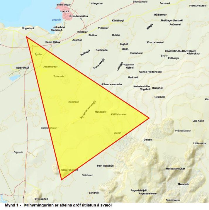
The map below shows an area where people have to stick to marked hiking trails. Locals and outdoor enthusiasts who have walked around the area know this well, but now it is necessary to draw attention to this.

013D4C6AC1E2FCC11F39A123127EF22D8525268E3699789CDE56006CFD921AA6_713x0.jpg
Cannonballs, grenade launchers and practice bombs are hidden in the area.THE POLICE
It also says that the geysers are not accessible to tourists under the current conditions. The air quality is bad and there could be pollution from the eruption and wildfires....
 
No major changes. There are some quake swarms, which is unusual during these fissure eruptions, but IMO noted them in their recent update and suggested that it was because the eruption is in a new place and tension is being released.

RUV is still covering the ordnance situation. There's a video here (Icelandic) that has some pictures of US and Icelandic military personnel on their search.

Browser translation of excerpt from the article:

...Lava from the eruption flows through Vogaheiði, which was a training ground for the US Army between 1952 and 1960.

The Coast Guard, along with the US Navy, searched for bombs in the lava this week, after a passerby came across an active bomb on his way to the craters...

As far as I know, none have been set off by this eruption's lava flows and/or seismicity yet.
 
Well, this particular eruption is over, per IMO (autotranslated).

It's nice that it was touristy (and that nobody got blown up by leftover bombs =8-O ), but the real joy is that Grindavik and the power plant were spared. I fully expected one or both to go under lava -- this has been the highest volume since December, though they haven't put a figure on it -- and it was chilling when, shortly after the eruption's start, Sudernes authorities issued a public statement warning that the geothermal heat might be cut again.

What a lucky break that the northern part of the dike opened up instead!
 
Last edited:
No changes, just a Sentinel 2 image of the lava field taken this weekend plus some comments from University of Iceland experts (Facebook translation):

gxde-ulxwaakmza.jpg


What it doesn't show is the limitations of the barriers: lava flows piling up against and eventually able to top them (fortunately, the eruption site shifted north this last time, so overtopping didn't happen, but is that a permanent change?).
 
There's no particular changes -- the sill continues to inflate again -- but <layperson speculation> there were some moderate earthquakes in the Krysuvik system northeast of the Sundhnuks area today as well as swarms in the general area of the recent eruption since that ended. I see no official comment or any news coverage but wonder whether the Peninsula will wait the weeks to months suggested by the Southern Volcanoes group before firing up again. At least nothing has shown up on the vafri.is graphic near Grindavik -- hope Earth has that crossed off its list now! </layperson speculation>
 
Did not expect this last year when the town first was evacuated: they're opening up Grindavik on October 21.

Reportedly (autotranslated), it is mainly for supporting the town's economic basis (the government has bought up most residential properties), and Grindavik's long-term fate is still uncertain.

However, if this works out and future eruptions continue to stay north, those incredible lava barriers here and at the power plant area will have been well worth it.

If...

The lava is already up close to the top of the Grindavik barrier, and at the last eruption's start, authorities warned that the plant's geothermal supply system might be cut again.

Fortunately, the eruption sites moved northward juuuust far enough to relieve that threat.

Since then, seismicity appears to this layperson as being in that same northerly region, not back at the former site just north of Grindavik, but who knows? Nobody has ever recorded how Reykjanes Peninsula volcanism starts up after one of its long naps, so no one can really predict in detail what will happen next (and where).

IMO issued an update today (informally, Benedikt told mbl.is earlier this week that they might expect something in mid-November). Both sources note that eruption volume is increasing.

Via GT:

Landris and magma accumulation under Svartsengi continues​

Nothing in the data suggests that magma accumulation under Svartsengi is stopping​

17.10.2024


Updated October 17 at 15:00

  • GPS measurements in the Svartsengis area show that the land surface is stable
  • If magma accumulation continues at a similar rate as recently, the most likely scenario is that another magma flow and possible eruption will occur in the Sundhnúks crater series as a result
  • Warning of an impending eruption can be very short, as little as 30 minutes
  • Seismic activity around the Sundhnúks crater series remains very low
  • Risk assessment is unchanged
Landris and magma accumulation under Svartsengi has continued at a similar pace for the last week. GPS measurements in the Svartsengis area show that the land surface is stable. Last week, model calculations based on the GPS data showed that the magma influx under Svartsengi has slightly decreased. There is no indication that it has slowed down more. Nothing in the data indicates that magma accumulation under Svartsengi is stopping.

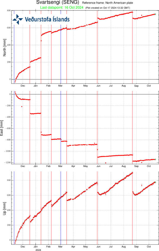
SENG_17102024


Records of the GPS station SENG at Svartsengi since November 11, 2023 in north, east and vertical (top, middle, bottom). The bottom curve shows landris in millimeters, and yesterday's measurement (October 16) is shown as a green dot. The red lines are the timings of the beginnings of the last six eruptions (December 18, 2023, January 14, February 8, March 16, May 29, and August 22, 2024). The blue lines represent the timing of magma flows that have occurred without an eruption (November 10, 2023 and March 2, 2024).

Lessons learned from previous magma flows and eruptions are useful in estimating how much magma must be added beneath Svartsengi to trigger the next event. In the last eruption, on August 22, model calculations assumed that about 24 million m3 of magma passed from the magma accumulation area under Svartsengi into the Sundhnúks crater series. The trend has been that as much or more magma must accumulate in the magma chamber than was released in the previous event to trigger a new magma flow and possible eruption.


If magma accumulation continues at a similar rate as recently, the most likely scenario is that another magma flow and possible eruption will occur in the Sundhnúks crater series as a result. There is still considerable uncertainty about the time until the next possible magma flow and eruption. The ongoing development of magma accumulation will be carefully monitored and an attempt will be made to estimate the time until the next event.


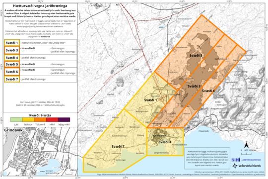
The updated hazard assessment remains unchanged​

The risk assessment has been updated and remains unchanged. However, there is still a risk due to a fall in cracks in area 4 in Grindavík. The risk assessment is valid until October 29, all things being equal.


Haettusvaedi_VI_17Oct_2024

(Click on the map to see it larger)


Warning of an impending eruption can be very short​

The first signs of magma flow are the intensity of earthquakes, a rapid increase in deformation and pressure changes in boreholes. The time that passes from the first signs to the start of a possible eruption can be very short, down to 30 minutes as in the last eruption on August 22.
 
Back
Top