
Navigation
Install the app
How to install the app on iOS
Follow along with the video below to see how to install our site as a web app on your home screen.
Note: This feature may not be available in some browsers.
More options
-
Welcome to TalkWeather! We see you lurking around TalkWeather! Take the extra step and join us today to view attachments, see less ads and maybe even join the discussion. CLICK TO JOIN TALKWEATHER
You are using an out of date browser. It may not display this or other websites correctly.
You should upgrade or use an alternative browser.
You should upgrade or use an alternative browser.
Hurricane Hurricanes Imelda and Humberto
- Thread starter wx_guy
- Start date
I would not put any faith in any computer model forecast for Imelda before it has fully formed. We're still logging new potential scenarios, currently. I want the no-landfall scenario to verify, but I'm still concerned about things like whether this is going to be a coast walker for Florida with how far west it forms, much less what happens further north.
IJS.
IJS.
Last edited:
I also hate to mention this, but at the end of the 06Z ECMWF at 144, Imelda is moving back west towards the coast after having lost the influence of Humberto. Pulled out a little ways, then released
- Thread starter
- #124
wx_guy
Member
- Messages
- 1,237
- Reaction score
- 4,443
- Location
- United States
- HAM Callsign
- KO4ZGH
- Special Affiliations
- SKYWARN® Volunteer
- ARRL Member
Yeah, I think there's a high chance the windshield wiper effect WILL happen. There's still too much uncertainty in the modeling.Hopefully, they don't windshield wiper their way back over the Carolinas.
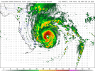
Looks like Imelda is forming right around Duncan Town in the far south of the central Bahamas.
12Z GFS holds with the pull out to sea, but is also showing Humberto losing it's grip and leaving Imelda sitting alone to reform and come back west, albeit on a much longer circle than ECMWF. Never gets further north than SC on this run - heads out due east, then reverses course starting at 150. Doesn't really reform though - continues to weaken as it heads back west, but that's a long way out on the model.
Imelda back in the Bahamas at 250, IKYN. Total lala land for the model of course, no real confidence at that timeframe. Still, it shows fujiwhara scenario - Humberto catching a hold of Imelda, then losing grip as a high splits the systems. At this point, I think the models are catching on to potential variables as much as anything, with the "splitting high" being one of those variables.
Imelda back in the Bahamas at 250, IKYN. Total lala land for the model of course, no real confidence at that timeframe. Still, it shows fujiwhara scenario - Humberto catching a hold of Imelda, then losing grip as a high splits the systems. At this point, I think the models are catching on to potential variables as much as anything, with the "splitting high" being one of those variables.
Last edited:
Humberto has that "perfect disk" look to him. If that's not a Cat 5 today, it's going to get really close.
How is Humberto not a Category 5?
Here I compare Humberto and the false Category 5 of 2019: Hurricane Lorenzo.
Coincidentally enough, while not in the same location they both happened around this day of the year.
Both systems in the following image were or are around 120-125 kts at the time:
Lorenzo:

Lorenzo was officially 120 kts in this GIF
Humberto recently:

Officially is 125 kts right now per the NHC
Here I compare Humberto and the false Category 5 of 2019: Hurricane Lorenzo.
Coincidentally enough, while not in the same location they both happened around this day of the year.
Both systems in the following image were or are around 120-125 kts at the time:
Lorenzo:
Lorenzo was officially 120 kts in this GIF
Humberto recently:
Officially is 125 kts right now per the NHC
slenker
Member
I expect the NHC to have Humberto as a 155 mph C4 or higher on the next update - it has the look of a C5 already.


Humberto is a very classically photogenic storm. Very symmetrical.

- Thread starter
- #132
wx_guy
Member
- Messages
- 1,237
- Reaction score
- 4,443
- Location
- United States
- HAM Callsign
- KO4ZGH
- Special Affiliations
- SKYWARN® Volunteer
- ARRL Member
I'd be exceedingly surprised if the forecast "locked" into the hard right turn. There's so much variation here that I think a whip back to the west is inevitable.
The idea that Humberto exerts that level of influence is dependent on the strength of Imelda, which I fear is going to be the confounding factor. I've never seen a closed-circulation over the gulf stream struggle to strengthen like the models show Imelda struggling. Could happen, but I think what we are seeing is a limitation in the models to handle intensity properly in the current situation with SSTs and deep TCHP as high as it is. A stronger Imelda would have more ability to resist the pull of Humberto. With all that said - there is NO DOUBT that Humberto is going to be strong, so the pull out to sea is a very plausible scenario. Google's Deepmind AI model has been locked in to the hard right turn from the beginning, for what it's worth. We'll see. This is the least confident I have felt about making any armchair forecast for a storm ever though, I'll say that. Entirely too many variables.I'd be exceedingly surprised if the forecast "locked" into the hard right turn. There's so much variation here that I think a whip back to the west is inevitable.
I swear, every new frame that loads of Humberto is prettier. What a gorgeous storm. The CDO is so very symmetrical.

@Blountwolf @Kds86z @wx_guy @JPWX @slenker
18Z ATCF is up at 135 kts (155 mph)
Let’s hope the NHC goes 5 kts higher at the 5pm advisory, because this is definitely deserving of Category 5 status.
18Z ATCF is up at 135 kts (155 mph)
| AL, 08, 2025092718, , BEST, 0, 228N, 608W, 135, 926, HU |


Correction in the 18Z ATCF@Blountwolf @Kds86z @wx_guy @JPWX @slenker
18Z ATCF is up at 135 kts (155 mph)
Let’s hope the NHC goes 5 kts higher at the 5pm advisory, because this is definitely deserving of Category 5 status.
AL, 08, 2025092718, , BEST, 0, 228N, 608W, 135, 926, HU
| AL, 08, 2025092718, , BEST, 0, 227N, 607W, 135, 929, HU, |
18Z NAMNST at 30hrs, for what it's worth:

And then at 40:

And then at 40:

18ZHRRR - a lot further north, a lot less organized. Pretty far west though:
