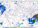
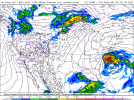
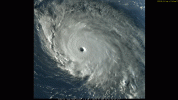
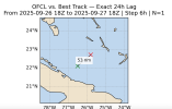
18ZNAM right turns Imelda off shore of <checks notes> Lake Okeechobee at 60... beginning the fujiwhara dance WAY earlier, but with a much stronger Imelda. I have no idea what to make of this scenario, other than... huh? more strengthening, but yet a quicker right turn? OK then. Yet another scenario on the list... lol.
Navigation
Install the app
How to install the app on iOS
Follow along with the video below to see how to install our site as a web app on your home screen.
Note: This feature may not be available in some browsers.
More options
-
Welcome to TalkWeather! We see you lurking around TalkWeather! Take the extra step and join us today to view attachments, see less ads and maybe even join the discussion. CLICK TO JOIN TALKWEATHER -
Current Tropical Systems Melissa
You are using an out of date browser. It may not display this or other websites correctly.
You should upgrade or use an alternative browser.
You should upgrade or use an alternative browser.
Hurricane Hurricanes Imelda and Humberto
- Thread starter wx_guy
- Start date
TornadoFan
Member
Humberto now a Category 5 with 160 MPH sustained winds.
- Thread starter
- #144
wx_guy
Member
- Messages
- 1,237
- Reaction score
- 4,443
- Location
- United States
- HAM Callsign
- KO4ZGH
- Special Affiliations
- SKYWARN® Volunteer
- ARRL Member
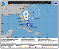
The 5 PM advisory for TD 9 also is shifted further west still, and any further west could threaten FL.
Kds86z
Member
Hey, what's the chances we get a whole new scenario from 12ZECMWF for Imelda? LOL. (100%. )
TornadoFan
Member
Kds86z
Member
#history
12ZECMWF is still holding with very weak Imelda up the coast, then right turn at the SC coast, but rapidly strengthening it now as it turns?
JBishopwx
Member
With Humberto now a cat 5, this is the first time in 92 years with multiple Category 5 hurricanes in back to back years. The previous time was during in the Great Depression in 1932/1933.
- Thread starter
- #154
wx_guy
Member
- Messages
- 1,237
- Reaction score
- 4,443
- Location
- United States
- HAM Callsign
- KO4ZGH
- Special Affiliations
- SKYWARN® Volunteer
- ARRL Member
Curious about this one, because the Euro is really bad at intensity, and intensity in this case could mean a lot. So hmm...Ugh - 12ZECMWF - Humberto loses hold and Imelda landfalls on the outer banks. (weak, disorganized the whole time)
View attachment 46751
I'm not confident we have the computing power or experience to model this. I expect this to be an almost unforecastable event. That's not a statement I like to make - as a huge fan of meteorology and all the science behind it that I totally believe in, I see the forecast issue as just that there are an overwhelming amount of variables for the systems to process with two systems interacting. We just haven't seen enough to be confident in the science behind the binary interaction. I am very hopeful the weak and totally off-shore scenarios verify, but if I lived on the east coast from FL to VA, I would not be letting my guard down. My personal gut feeling is that if it spins, it wins near the gulf stream. I expect Imelda to become a hurricane off the FL coast, myself. I'll be thrilled to be wrong on that though. Beyond that, the scenario where Imelda stalls from the counter-clockwise fujiwhara pull seems realistic, but is SUCH a close call that it's going to be nerve wracking. The earlier runs we saw where Imelda loops through the Carolinas before reemerging seems as realistic of a scenario to me as the hard right turn - the same fujiwhara reaction, just over a larger area. That was modeled well before Humberto was a 5 though, so likely the models now are assuming total dominance of Humberto in the area. It's fascinating to watch it all.
Last edited:
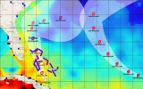
Here's the biggest factor giving me pause. This is TCHP. Notice where Humberto is, as a 5. Now look at where Imelda is forming, and where it will travel. Simply put, Imelda will have better ocean fuel than Humberto - and as Humberto moves north, that difference gets greater, as Imelda will be riding the gulf stream north, and Humberto will be over increasingly less heat content.

Last edited:
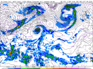
18ZGFS follows the NAM with the "somewhat stronger, earlier right turn" scenario, with the right turn happening off Jacksonville, FL., then Imelda wanders around the Atlantic for a while after Humberto drops her.
(Sounds like a dang soap opera - As the Hurricanes Turn)
Still hanging around looking for her lost love on <checks notes>... October 8th.
(Sounds like a dang soap opera - As the Hurricanes Turn)
Still hanging around looking for her lost love on <checks notes>... October 8th.

- Thread starter
- #159
wx_guy
Member
- Messages
- 1,237
- Reaction score
- 4,443
- Location
- United States
- HAM Callsign
- KO4ZGH
- Special Affiliations
- SKYWARN® Volunteer
- ARRL Member
Just a curious outlier for now, but the HAFS-A path hooks to the left instead of to the right, into GA/FL instead of out to sea.
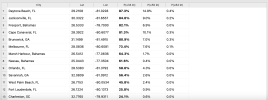
Here's my program that somewhat mirrors the NHC's wind probabilities. As mentioned before, it uses the forecast track (in this case the HAFS-A), the wind radii forecast, and a Monte Carlo simulation based on errors published by the NHC to simulate 3000 possible tracks for every time step, and takes the union over all time steps.
Here's my program that somewhat mirrors the NHC's wind probabilities. As mentioned before, it uses the forecast track (in this case the HAFS-A), the wind radii forecast, and a Monte Carlo simulation based on errors published by the NHC to simulate 3000 possible tracks for every time step, and takes the union over all time steps.

- Thread starter
- #160
wx_guy
Member
- Messages
- 1,237
- Reaction score
- 4,443
- Location
- United States
- HAM Callsign
- KO4ZGH
- Special Affiliations
- SKYWARN® Volunteer
- ARRL Member

