• Welcome to TalkWeather!
    We see you lurking around TalkWeather! Take the extra step and join us today to view attachments, see less ads and maybe even join the discussion.
    CLICK TO JOIN TALKWEATHER

Hurricane Hurricanes Imelda and Humberto

Just a curious outlier for now, but the HAFS-A path hooks to the left instead of to the right, into GA/FL instead of out to sea.
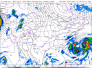
Parks it off Savannah (for 24 hours!) and then pulls out to sea on the 18Z.
 
Last edited:
Here's the original cone from yesterday versus where it's actually gone. Hugging just the to the west of the Cone by 66.1 nautical miles west of the forecasted spot.

1759020352745.png


The 0z spaghetti models are pretty much "all in" on the hard right hook. It's just such a nail biter!!
 
If it becomes a clearer threat to land, this will be a nightmare for state and local EMAs to communicate to the public. Half a chance it just says "haha see ya" and never hits land at all and there's 1,000 possible scenarios for how strong it will be and where it will make landfall. Definitely posed to test the limits of forecasting, computer modelling and public communications.
 
Insane image from the ISS of Category 5 Major Hurricane Humberto’s eye
IMG_8594.jpeg
 
The pressure inside Humberto’s eye could have nearly matched that of Erin earlier this year
 
18ZECMWF was up to SC coast, right turn, out 100 miles, then moving back west when dropped at the end of the range.
 
Whatever this is still has my vote - NAM believes this is going to happen, and is sticking to it. 0ZNAM.
1759027022509.png
1759028005264.png

I will say I do not like the idea of Imelda, potentially stronger, pulling Humberto further NW like this shows.

Whoa, neat. The last frame at 84:
1759028116057.png
 

Attachments

  • 1759026851584.png
    1759026851584.png
    389.7 KB · Views: 0
Last edited:
The amount and intensity of the convection south of Cuba is surprising me.
1759033662141.png
 
The models this morning are totally sold on the hard right turn before it reaches any land, and so is the NHC. I'm exceedingly curious if its westward jog will matter at all. From the initial Cone 42 hours ago, it is 111 nautical miles away from the forecasted location (outside the cone).

For reference, Humberto's Cone matches the forecasted location going back as much as 5 days.


So to-be Imelda is probably going to continue to be a thorn in forecasters' sides.


1759064481511.png
 
*shrugs curiously*

That's quite the model convergence on that rightward turn. Certainly hope this prevails, but still a bit wary of a possible westward path.
1759066069814.png1759066081559.png
 
Humberto is certainly the dominant actor on this stage. I'm very glad to see the model convergence on the right turn solution, and if it happens, I'll be thrilled both for the spared east coast and for the ability of our models to handle fujiwhara interactions.

With that said, I will also not be as surprised as usual if nature decides it has other plans.
 
Sunday brunch look - Humberto looking great, Imelda forming over the western Bahamas, and nature proving it likes repeating patterns in the Gulf. (nothing expected there but a swirl, AFAIK, but is interesting to me, regardless)

1759076184587.png

Quick model rundown:

06ZECEMWF - early right turn, Imelda never really consolidates, Humberto absorbs.
12ZGFS - FL/GA line right turn, stronger than Euro
12ZNAM - Strongest Imelda, early right turn, crazy yin/yang fujiwhara in the Atlantic
06ZHAFS A and B - reasonably strong Imelda, right turn around Orlando
06ZHWRF - Still convinced of the "mouth of the Savannah River" parking, then out to sea from there.
08ZHMON - Similar to HAFS A&B, right turn around Orlando's latitude, less organized
 
Last edited:
Back
Top