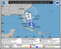
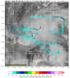
18ZGFS is yet another scenario - Imelda never makes landfall, Humberto catches her right before and pulls her out to sea.
Navigation
Install the app
How to install the app on iOS
Follow along with the video below to see how to install our site as a web app on your home screen.
Note: This feature may not be available in some browsers.
More options
-
Welcome to TalkWeather! We see you lurking around TalkWeather! Take the extra step and join us today to view attachments, see less ads and maybe even join the discussion. CLICK TO JOIN TALKWEATHER -
Current Tropical Systems Melissa
You are using an out of date browser. It may not display this or other websites correctly.
You should upgrade or use an alternative browser.
You should upgrade or use an alternative browser.
Hurricane Hurricanes Imelda and Humberto
- Thread starter wx_guy
- Start date
N0mz
Member
Humberto now a 4. I'd give it better than 50% odds to reach cat 5
TornadoFan
Member
18Z ECMWF follows the GFS, Imelda stays really undeveloped almost all the way to the SC coast, then gets pulled out by Humberto. I like this - hope this trend of no landfall scenarios continues!
I'm just having a hard time believing that with every other storm overperforming in intensity that Imelda is going to struggle as much as forecast. Maybe the models are thinking it will suck in some of the slug of dry air currently in the northern Gulf?
TornadoFan
Member
And there we have Category 4 Humberto with 145 MPH sustained winds.
Kds86z
Member
Wow #3 since 1939. OfficialAnd there we have Category 4 Humberto with 145 MPH sustained winds.
Humberto has had a 70mph (75 to 145) wind increase in 18 hours and a 50mbar (990 to 940) pressure drop as well.
Interestingly, Humberto 2025 has had a bigger wind increase in 18 hours than Humberto 2007 did. Hurricane Humberto in 2007 only saw a 50mph wind increase in 18 hours.
Interestingly, Humberto 2025 has had a bigger wind increase in 18 hours than Humberto 2007 did. Hurricane Humberto in 2007 only saw a 50mph wind increase in 18 hours.
Last edited:
00ZGFS coming in. Closer to the FL coast, but then a hard right turn out to sea off the GA coast as Humberto pulls Imelda out to dance.
N0mz
Member
Not sure if this was posted but NHC forecasted Humberto to 140kt (cat 5) for 00z on the 28th
- Admin
- #112
- Messages
- 2,320
- Reaction score
- 1,989
- Location
- Meridianville, Al
- Special Affiliations
- SKYWARN® Volunteer
GFS intensifies this as it heads out NE away from land down to the 960s and 970s
- Thread starter
- #114
wx_guy
Member
- Messages
- 1,237
- Reaction score
- 4,443
- Location
- United States
- HAM Callsign
- KO4ZGH
- Special Affiliations
- SKYWARN® Volunteer
- ARRL Member
The errors from 48-hours ago for the GFS -- the "center" is significantly further west than forecast.
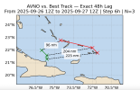
Just to show this, to make landfall in Jacksonville, Florida, the 12z official Best Track just needs to be 145 n mi off the current center prediction.
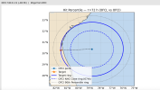
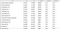
Here's my rendition of the current chances of sustained winds at any point in the next 120 hours. The algorithm uses the NHC track and forecast wind radii, 5-year error distribution, and a Monte Carlo simulation of 3000 possible jiggles of the track in order to produce its estimates. These numbers will inevitably change as time goes on. Notably, it currently keeps all hurricane-force winds offshore.

Just to show this, to make landfall in Jacksonville, Florida, the 12z official Best Track just needs to be 145 n mi off the current center prediction.

Here's my rendition of the current chances of sustained winds at any point in the next 120 hours. The algorithm uses the NHC track and forecast wind radii, 5-year error distribution, and a Monte Carlo simulation of 3000 possible jiggles of the track in order to produce its estimates. These numbers will inevitably change as time goes on. Notably, it currently keeps all hurricane-force winds offshore.

Jacob Aden
Member
Humberto reminds me a lot of Dorian. Humberto is definitely a category 5 at this point.
Last edited:
Jacob Aden
Member
Well the rocket is about to launch with this one now that we got a center so quicklyView attachment 46730
That will do it, Imelda has formed. (Yes, I know, it is technically only a TD, based on the storm's structure, Imelda will be along shortly.)
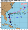
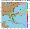
Wow, what a change in modelling over just a day or so. Forecasts now mostly favor the storm center remaining offshore. Worth noting, though, as @wx_guy mentioned, the center is further west than anticipated by guidance. Good chance it pulls a Dorian and scrapes by the eastern coast of FL.


Jacob Aden
Member
Officially TD9 as of the 11:00 A.M update. Still has a bit of work to do, either killing off or absorbing the southern end of the wave axis. Conditions in the Bahamas are extremely favorable for intensification. I would not be surprised at all if Imelda exceeds the current intensity guidance.
Jacob Aden
Member
Hopefully, they don't windshield wiper their way back over the Carolinas.Wow, what a change in modelling over just a day or so. Forecasts now mostly favor the storm center remaining offshore. Worth noting, though, as @wx_guy mentioned, the center is further west than anticipated by guidance. Good chance it pulls a Dorian and scrapes by the eastern coast of FL.
View attachment 46731View attachment 46732

