• Welcome to TalkWeather!
    We see you lurking around TalkWeather! Take the extra step and join us today to view attachments, see less ads and maybe even join the discussion.
    CLICK TO JOIN TALKWEATHER

Archive Former Hurricane Nate

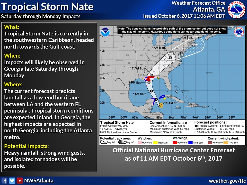
Another shift east ... <sigh> Although good for NOLA.
DLdsftBXcAA0ZAo.jpg:large
 
Not understanding their logic with such a far shift east...latest globals continue to landfall this over SELA with a NNE to eventually NE curve over MS and AL. GFS/CMC/00z Euro consensus are west of their track, but okay.
 
And the 12z Euro with a track pretty much over NOLA. Granted, this will be an eastern loaded system. I just cannot believe they bit on the 12z tropical models. LOL.
 
Up to 60mph.


4:00 PM CDT Fri Oct 6
Location: 20.3°N 85.7°W
Moving: NNW at 21 mph
Min pressure: 993 mb
Max sustained: 60 mph
 
Heading to bed but thought I would share.

4:00 AM CDT Sat Oct 7
Location: 24.5°N 87.0°W
Moving: NNW at 22 mph
Min pressure: 987 mb
Max sustained: 80 mph
 
This thing is ramping up nicely. Recon keeps finding lower pressures every pass. Latest I've seen was 985, but thankfully its moving fast.

On another note, nearly all models are making landfall OUTSIDE of the cone of error around Barataria Bay/Plaquemines Parish. This looks like a huge Forecasted Convective Amplification Deficiency for the NHC which went with hurricane models over our best globals. Seems boneheaded to me.

Kory, that's more East, yes? I'm sorry ... I just got up and checked here first. Haven't seen any updates aside from here.
 
Mid town Mobile checking in. Cloudy but otherwise pleasant. Just heard Nate is now 90 mph and moving at 26 mph. I'm looking for a model by LSU that projects storm surge that you can pull down to street level. I found it yesterday. I tried to find it this morning. I know it's not StormDat. Can anybody help? Thanks!
 
Mid town Mobile checking in. Cloudy but otherwise pleasant. Just heard Nate is now 90 mph and moving at 26 mph. I'm looking for a model by LSU that projects storm surge that you can pull down to street level. I found it yesterday. I tried to find it this morning. I know it's not StormDat. Can anybody help? Thanks!
Keep us posted! I just activated the storm titles for those in the storm. You were the first to get one.
 
OUTER RAINBANDS OF NATE MOVING ONSHORE IN SOUTHEASTERN
LOUISIANA...


SUMMARY OF 100 PM CDT...1800 UTC...INFORMATION
----------------------------------------------
LOCATION...27.6N 88.9W
ABOUT 105 MI...170 KM S OF THE MOUTH OF THE MISSISSIPPI RIVER
ABOUT 195 MI...315 KM S OF BILOXI MISSISSIPPI
MAXIMUM SUSTAINED WINDS...90 MPH...150 KM/H
PRESENT MOVEMENT...NNW OR 340 DEGREES AT 25 MPH...40 KM/H
MINIMUM CENTRAL PRESSURE...982 MB...29.00 INCHES
 
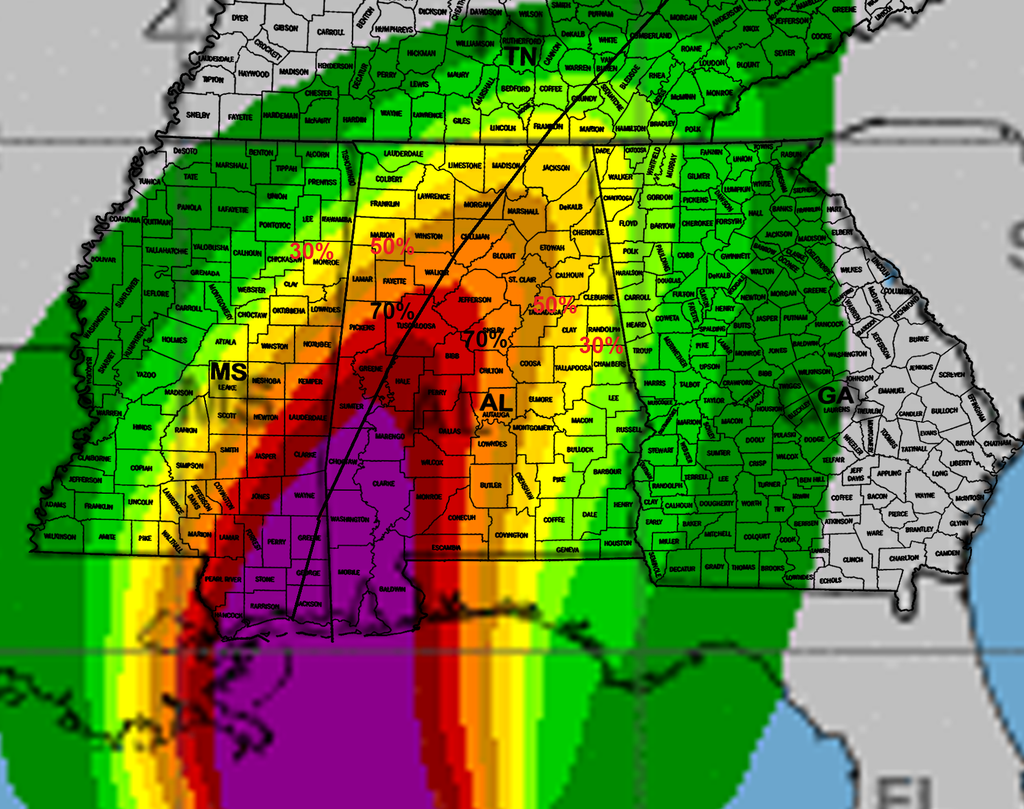
Latest Tropical Storm force wind probabilities from the NHC. The track for this is based off the west shifted 10am advisory, next track update is 4pm which could shift or change this area on the next wind probabilities map issued at 7pm.

Nate_zpsdkxkturh.png
 
Tornado Warning Baldwin Co.

Looks like a possible tornado near Romar Beach and another near Gulf Shores T

WKRG Live Stream:
 
Tornado Warning allowed to expire. At least one tv station reported seeing it on their camera network and this LSR was filed by MOB.


0153 PM WATER SPOUT 1 ESE GULF SHORES 30.24N 87.68W
10/07/2017 GMZ650 AL FIRE DEPT/RESCUE

GULF SHORES FIRE DEPARTMENT REPORTING A WATERSPOUT
OFFSHORE.
 
Looks like they have had several. Here is one
 
Oil platform AWOS 55 miles East of Venice, LA reporting sustained tropical storm force winds.

sustained 38kts (44mph)... gust to 50kts (58mph) at kvky. station on platform at 115 meters.
 
Back
Top