• Welcome to TalkWeather!
    We see you lurking around TalkWeather! Take the extra step and join us today to view attachments, see less ads and maybe even join the discussion.
    CLICK TO JOIN TALKWEATHER

Severe WX February 16-17th, 2022 Severe Threat

Tennie

Member
Messages
960
Reaction score
791
Location
Tennessee
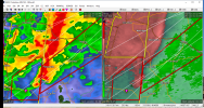
Storm NE of Philadelphia, MS is spinning like a top. Little surprised it doesn't have a warning with it yet.
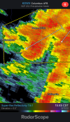
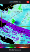
It has one now:

175
WFUS54 KJAN 172059
TORJAN
MSC069-103-172145-
/O.NEW.KJAN.TO.W.0008.220217T2059Z-220217T2145Z/

BULLETIN - EAS ACTIVATION REQUESTED
Tornado Warning
National Weather Service Jackson MS
259 PM CST Thu Feb 17 2022

The National Weather Service in Jackson has issued a

* Tornado Warning for...
Central Noxubee County in east central Mississippi...
Northwestern Kemper County in east central Mississippi...

* Until 345 PM CST.

* At 259 PM CST, a severe thunderstorm capable of producing a tornado
was located near Preston, moving northeast at 65 mph.

HAZARD...Tornado.

SOURCE...Radar indicated rotation.

IMPACT...Flying debris will be dangerous to those caught without
shelter. Mobile homes will be damaged or destroyed.
Damage to roofs, windows, and vehicles will occur. Tree
damage is likely.

* This dangerous storm will be near...
Gholson around 310 PM CST.
Macon and Paulette around 325 PM CST.
Prairie Point around 330 PM CST.
Bigbee Valley around 340 PM CST.

Other locations impacted by this tornadic thunderstorm include
Shuqualak.

PRECAUTIONARY/PREPAREDNESS ACTIONS...

TAKE COVER NOW! Move to a basement or an interior room on the lowest
floor of a sturdy building. Avoid windows. If you are outdoors, in a
mobile home, or in a vehicle, move to the closest substantial shelter
and protect yourself from flying debris.

&&

LAT...LON 3301 8834 3272 8891 3293 8891 3293 8882
3299 8881 3329 8835 3329 8831
TIME...MOT...LOC 2059Z 234DEG 56KT 3283 8886

TORNADO...RADAR INDICATED
MAX HAIL SIZE...<.75 IN

$$

TW
 
Messages
2,841
Reaction score
4,588
Location
Madison, WI
That little guy looks really wrapped up; reflectivity just brightened up at the tip of the hook (possible debris ball) coincident with a little green blip on CC.
 

Attachments

  • GWX_2133.png
    GWX_2133.png
    694.4 KB · Views: 0

Kragg

Member
Messages
131
Reaction score
146
Location
Burning Hams
I’m surprised the storm east of Philadelphia only has a severe and not TOR
 

Attachments

  • 5F4902F8-5FDF-42B1-8F88-5B469DC5F5FE.png
    5F4902F8-5FDF-42B1-8F88-5B469DC5F5FE.png
    340.4 KB · Views: 0
  • 66C20BB8-6935-4D72-A4CB-2C9AA9237B14.png
    66C20BB8-6935-4D72-A4CB-2C9AA9237B14.png
    297.7 KB · Views: 0

Austin Dawg

Member
Sustaining Member
Messages
866
Reaction score
1,335
Location
Leander, Texas
It looks for my untrained eye like we have a spin ups starting all the way down to Meridian Station. I'm afraid it's going to be really tough the next couple hours. It looks like it's running into something just as it comes into the Alabama line
 

bwalk

Member
Messages
597
Reaction score
291
Location
Prattville, Al
Tuscaloosa Co cell looks like it will move over rural areas for the near future after it skirts Samantha community. Has any spotter been able to confirm actual tornado? NWS says radar indicated.

Edit: Cell did not skirt Samantha but the couplet is very loose.

1645136178468.png
 
Logo 468x120
Back
Top