Sawyerville-Eoline, Alabama EF3 - 04/27/2011
Path Length: 72.13
Fatalities: 7
Injuries: 52
This tornado was overshadowed by others in the area. Even so, dozens of rural homes were decimated, and remarkable vegetation damage occurred. About 2 miles after forming the tornado rapidly intensified. It demolished metal buildings and twisted their steel beams, disintegrated a trailer, and tossed outbuildings and mobile homes against tree lines over 100 yards away, all while scouring the ground, shredding shrubs, and smashing apart all kinds of trees.
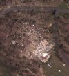
A small gravel road was almost completely buried under shifted forest and mud. These three images perfectly showcase the intensification of the tornado's extreme winds over time
View attachment 46223
View attachment 46224
View attachment 46225
The tornado also tossed cars like they were toys
View attachment 46226View attachment 46227
View attachment 46228
The only substantial structure that took a glancing blow in this area was a well built brick home that was completely leveled.
View attachment 46231
Plenty of mobile homes were hit though, and the increasing intensity of what was done to them paints a clear picture of how powerful this beast was.
View attachment 46229
The tornado likely reached maximum intensity over this patch of forest where, despite lacking any real debris load, numerous large trees were completely stripped of bark, with a defined area of ground trenching right in the middle.
View attachment 46230
The next 7.6 miles were spent entirely in unpopulated land, where the tornado weakened and then restrengthen. It entered the town of Eoline with formidable strength. The Eoline Volunteer Fire Department served as the city's storm shelter. 12 people were sheltered here when the tornado struck. "The roof just popped off 'poof' and then the bricks came swirling, the bricks were just slinging around." The station was destroyed with only two walls left standing, luckily this is where everyone was sheltering and no one was killed.
View attachment 46232
New Rating: F4
Reasons: This one is extremely tough to rate, and I went back and forth several times. On one hand, the debarking and scouring are incredible, and cars as well as mobile/manufactured homes were turned into airborne missiles that traveled WELL over 100 meters. On the other hand, the only substantial structures that were hit collapsed in place (there were more I didn't cover). I'm choosing F4 because I'm trying to imagine what this damage looked like on ground level without the assistance of satellite imagery painting the true scale of destruction. If the goal is to stay true to historical methods, satellite imagery can't be weighted as heavily as it would need to be here to give the F5 rating.
If anyone disagrees, I'm all ears. I'll call this rating "preliminary" for now.