• Welcome to TalkWeather!
    We see you lurking around TalkWeather! Take the extra step and join us today to view attachments, see less ads and maybe even join the discussion.
    CLICK TO JOIN TALKWEATHER
  • TalkWeather Tropical Weather Widget
    Active Tropical Systems
    Loading...
    Fetching latest NHC data...

Enhanced Fujita Ratings Debate Thread

Lake Martin, AL EF4 - 04/27/2011
Path Length: 44.18 miles
Fatalities: 7
Injuries: 30

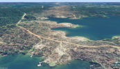
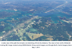
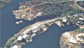
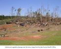
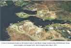
Damage over the western-central portions of Lake Martin
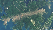
1755362877471.png
1755362948820.png
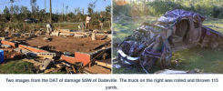
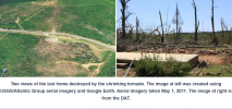
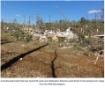
^^ Two fatalities occured here where two substantial homes were completely razed from their foundations.

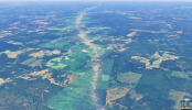
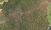
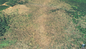
"A second intensity maxima occurred six miles east of Dadeville. A 40-50 yard swath of trees along the center line was stripped and debarked. There was a broader complex multi-vortex treefall pattern here that is only present in a very powerful tornado. The maximum total width of the tornado soared to 1,480 yards."
1755363269870.png

After another 4.5 miles the tornado reached the Tallapoosa-Chambers County border, where it narrowed and weakened. However the core winds struck a 100 year old frame house and left no trace.

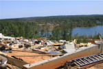
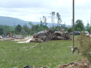
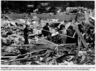
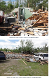
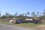
The remains of Mount Hebron East Baptist Church North of Eclectic.
1755363567454.png
1755363601722.png
1755363634496.png
1755363848111.png
1755363897024.png
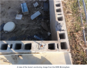
^^ A two story anchored home With a reinforced CMU foundation that was swept away.
1755364002710.png
1755364085552.png

New Rating: F5

Reasons: Strong frame houses blown away, cars (truck) thrown in excess of 100 meters, incredible tree damage and debarking.
 
Last edited:
I actually think Shoal Creek-Ohatchee’s wind speed was properly rated. Same thing with Bridgeport.
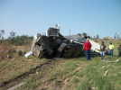
Interesting note about the Bridgeport tornado is it threw a semi truck over 100 yards! Very impressive and most certainly violent. The two well built homes it hit were blown over with all the debris left on the slab in textbook F4 fashion, so I agree it was properly rated. The semi-truck could be an F5 indicator, but it's the only really impressive contextual from the tornado's entire path, so I wouldn't say there's enough evidence for a higher rating.

1755369245578.png
1755369449269.png
 
Not seeing anything on Tornado Talk that points to F5 strength with the Enterprise/Yantley tornado. This is by far the most impressive damage, but construction wasn't finished

1755379181383.png

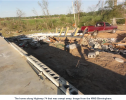
About 5.6 miles east of Enterprise, on Highway 514, the tornado reached peak intensity, EF4, with estimated winds of 175 mph. A newly constructed, well-built house was swept away. A clean slab was all that was left. Trees nearby were debarked. Typically this type of damage would be rated EF5 as the home was adequately anchored, and no debris was left on the foundation. However, the interior walls were not yet constructed, which meant that the structural integrity was weakened. A well-built neighboring home was unroofed.
 
I highly doubt it (I?) reached EF5 status, just saying. EF4 was appropriate from what I've seen.
Ok then F5. Either way, if we're going for Fujita era consistency this earns the 5 all the way. See those anchor bolts? Truck tossed over 100 meters. Trees shredded. That's a lot of slabbage for lake front properties (rich people houses lol). The scar doesn't lie either.

Doesn't matter too much either way,but had to give your tornado a deeper look!
 
Rosalie-Ider, Alabama EF3 - 11/30/2016
Path Length: 13.5 miles
Fatalities: 4
Injuries: 9

This was one of 39 tornadoes, during a 2-day outbreak. The worst damage occurred at a one-story day care center that was completely destroyed and blown off its foundation. It was anchored, but the survey team noted the floor plates connecting the foundation were observed to have "some degree of degradation". Multiple buildings with CMU block construction were blown over as well, including a grocery store with no pictures I could find.

Here's one of the CMU structures
1755531416412.png

And here's the daycare
1755531528877.png


I don't see any sign of degradation, but I'll take the surveyors word for it.

New Rating: F4

Reasons: Brick structures blown over and strong frame home blown away. The strong frame home would be an F5 indicator, but I subtracted one rating due to supposed degradation.

1755531841207.png
 
Last edited:
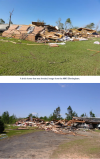
Ok then F5. Either way, if we're going for Fujita era consistency this earns the 5 all the way. See those anchor bolts? Truck tossed over 100 meters. Trees shredded. That's a lot of slabbage for lake front properties (rich people houses lol). The scar doesn't lie either.

Doesn't matter too much either way,but had to give your tornado a deeper look!
To be entirely fair, a house being anchored doesn't mean it's well built enough for even EF4 automatically, that house doesn't look terrible but it definitely doesn't look EF5, also an expensive home isn't always well built and I'd say it's usually not, Mayfield swept away tons in Cambridge Shores and they blanketed that with 170mph, Elkhorn also destroyed a few large expensive homes including a mansion and peaked at 170 as well, its not even expensive in itself to create a more wind resistant home (outside of flat house cost).

The truck is interesting but the heavy population of weak trees and also persistent off-coloring of 4/27 aerials can explain the super defined scar without it being super super high end, but I wouldn't doubt any EF4 on 4/27 COULD'VE had EF5 intensity, but this isn't matching damage
All very great points. However, I'm rating these tornadoes based on the original Fujita scale criteria. Here's the original "mission statement" for what I'm trying to accomplish.

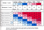
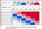
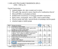
Lyza's article has inspired me. I subscribed to Tornado Talk premium and am going through all the EF era tornadoes in their database. I'm going to re-rate them based on these criteria from the original Fujita scale. I think the most important element will be the original scale's use of cars, trains, debarking, and "incredible phenomena" as rating criteria. I've also attached the EF scale rating descriptions so we can see if ratings are consistent with those.

I know this won't be perfect, but my goal isn't to be perfect. The goal is consistency. I've organized these tornadoes by state, so hopefully this will also help shed some light on some of the worst offending WFOs. In the interest of saving time I won't be posting tornadoes that were rated correctly, just the ones that were clearly underrated.

View attachment 45773
View attachment 45829
The goal is to rerate EF era tornadoes so they fit within the historical context of the previous 80 years of tornadoes. I'm not using the EF scale at all. I'll go back and edit all the "E"s out of the new ratings so there's less confusion.
 
PSA: If anyone with knowledge on the original Fujita scale era (@TH2002 for example) wants to weigh in and critique these more iffy ratings I'm definitely open to it. In my opinion, the 80s/90s were the best time for tornado ratings, so I think as long as I don't stray too far from the criteria used back then we'll be golden. I don't spend much time in the Significant tornadoes thread, but I know there's multiple F-scale era experts in there.

Lawrence-Morgan Counties, Alabama EF4 - 02/26/2008
Path Length: 16.7 miles
Fatalities: 4
Injuries: 23


Part of the Super Tuesday outbreak, this tornado leveled a 2300 square foot, 2-story brick house and almost entirely swept it off it's foundation. Large trees with diameters up to 4 feet were snapped and uprooted. Fence posts embedded in concrete were ripped out of the ground and tossed 50-100 feet. A truck was thrown more than 100 yards into an open field.

1755615780709.png1755616691237.png
1755615802860.png1755615824192.png
1755615883968.png

New Rating: F5

Reasons: Multiple vehicles, including trucks, thrown in excess of 100 meters. Brick home blown away.


Haleyville, Alabama EF3 - 04/27/2011
Path Length: 32 miles
Fatalities: 0
Injuries: 25


A little less than a half mile after forming the tornado crossed into Marion county (the 3rd EF3+ to do so in a two hour period), and rapidly became significant, snapping and uprooting every tree in its path. It stayed rural, and only hit a few structures for the first half of its life, tossing mobile homes and only leaving a few interior walls standing on well constructed brick houses.

Over the next 6 miles it stayed in forest, and slowly strengthened before entering the community of Whitehouse. Several injuries were noted here, and a "well-built", anchored home was wiped cleanly from its foundation, with some of the anchor bolts pulled out. Nearby hardwood and softwood trees were heavily debarked. Curiously, the DAT show the preliminary rating marker for this home was "EF3+" with a listed speed of 170 mph (EF4). Maybe NWS Birmingham forgot to finalize the survey due to the sheer number of violent twisters they had to survey.

At 3:10 in this video you can see the tornado (a violently rotating wedge) cross the road just one minute after striking the home.


1755617726804.png1755617746827.png
1755617778907.png

Another 6.7 miles further northeast and close to the Marion/Winston County border, two other houses were swept away. One was unanchored, the other was more substantial, and had its walk out basement area also leveled. These homes were never surveyed.

1755618015346.png

Here's a before image of the left hand house

1755618052406.png

New Rating: F4

Reasons: Two strong frame homes blown away. Significant debarking. Not enough confidence to go F5 because no vehicles appeared to be tossed great distances, and even with the homes being anchored, they were mostly unreinforced CMU foundations. The lack of vehicle tossing is more significant in my mind because of how wide the tornado was. If any evidence is found of cars being thrown over 100 meters, I'll upgrade the rating.
 
All very great points. However, I'm rating these tornadoes based on the original Fujita scale criteria. Here's the original "mission statement" for what I'm trying to accomplish.


The goal is to rerate EF era tornadoes so they fit within the historical context of the previous 80 years of tornadoes. I'm not using the EF scale at all. I'll go back and edit all the "E"s out of the new ratings so there's less confusion.
Got it got it, the new rating being EF 100% confused me and I assume everyone else lol, good luck
 
PSA: If anyone with knowledge on the original Fujita scale era (@TH2002 for example) wants to weigh in and critique these more iffy ratings I'm definitely open to it. In my opinion, the 80s/90s were the best time for tornado ratings, so I think as long as I don't stray too far from the criteria used back then we'll be golden. I don't spend much time in the Significant tornadoes thread, but I know there's multiple F-scale era experts in there.

Lawrence-Morgan Counties, Alabama EF4 - 02/26/2008
Path Length: 16.7 miles
Fatalities: 4
Injuries: 23


Part of the Super Tuesday outbreak, this tornado leveled a 2300 square foot, 2-story brick house and almost entirely swept it off it's foundation. Large trees with diameters up to 4 feet were snapped and uprooted. Fence posts embedded in concrete were ripped out of the ground and tossed 50-100 feet. A truck was thrown more than 100 yards into an open field.

View attachment 46189View attachment 46194
View attachment 46190View attachment 46191
View attachment 46192

New Rating: F5

Reasons: Multiple vehicles, including trucks, thrown in excess of 100 meters. Brick home blown away.


Haleyville, Alabama EF3 - 04/27/2011
Path Length: 32 miles
Fatalities: 0
Injuries: 25


A little less than a half mile after forming the tornado crossed into Marion county (the 3rd EF3+ to do so in a two hour period), and rapidly became significant, snapping and uprooting every tree in its path. It stayed rural, and only hit a few structures for the first half of its life, tossing mobile homes and only leaving a few interior walls standing on well constructed brick houses.

Over the next 6 miles it stayed in forest, and slowly strengthened before entering the community of Whitehouse. Several injuries were noted here, and a "well-built", anchored home was wiped cleanly from its foundation, with some of the anchor bolts pulled out. Nearby hardwood and softwood trees were heavily debarked. Curiously, the DAT show the preliminary rating marker for this home was "EF3+" with a listed speed of 170 mph (EF4). Maybe NWS Birmingham forgot to finalize the survey due to the sheer number of violent twisters they had to survey.

At 3:10 in this video you can see the tornado (a violently rotating wedge) cross the road just one minute after striking the home.


View attachment 46195View attachment 46196
View attachment 46197

Another 6.7 miles further northeast and close to the Marion/Winston County border, two other houses were swept away. One was unanchored, the other was more substantial, and had its walk out basement area also leveled. These homes were never surveyed.

View attachment 46198

Here's a before image of the left hand house

View attachment 46199

New Rating: F4

Reasons: Two strong frame homes blown away. Significant debarking. Not enough confidence to go F5 because no vehicles appeared to be tossed great distances, and even with the homes being anchored, they were mostly unreinforced CMU foundations. The lack of vehicle tossing is more significant in my mind because of how wide the tornado was. If any evidence is found of cars being thrown over 100 meters, I'll upgrade the rating.

You gotta find a way to introduce this system into some tornadoes if the damage is prevalent, it did help Plainfield get a 5IMG_7383-1.png
 
You gotta find a way to introduce this system into some tornadoes if the damage is prevalent, it did help Plainfield get a 5View attachment 46201
This is awesome!! Any idea where it came from?

Apologies for the confusion. Hopefully editing all the new ratings to F scale helps clear up my intent for people. I've already re-rated 12 tornadoes and the only states i've finished from Tornado Talk's archive are Georgia and about 2/3rds of Alabama. This might take a while XD. The 2011 Cordova tornado actually hasn't been covered by them, so if anyone wants to take a stab at that one please be my guest!
 
I
This is awesome!! Any idea where it came from?

Apologies for the confusion. Hopefully editing all the new ratings to F scale helps clear up my intent for people. I've already re-rated 12 tornadoes and the only states i've finished from Tornado Talk's archive are Georgia and about 2/3rds of Alabama. This might take a while XD. The 2011 Cordova tornado actually hasn't been covered by them, so if anyone wants to take a stab at that one please be my guest!
Couldn't tell you exactly where it came from, I found it 2nd hand, but I assume it's from a paper about Plainfield from Fujita, that's what it was used for, also no worries about the confusion, edit them and everyone will get it from now on for sure
 
Sawyerville-Eoline, Alabama EF3 - 04/27/2011
Path Length: 72.13
Fatalities: 7
Injuries: 52

This tornado was overshadowed by others in the area. Even so, dozens of rural homes were decimated, and remarkable vegetation damage occurred. About 2 miles after forming the tornado rapidly intensified. It demolished metal buildings and twisted their steel beams, disintegrated a trailer, and tossed outbuildings and mobile homes against tree lines over 100 yards away, all while scouring the ground, shredding shrubs, and smashing apart all kinds of trees.

A small gravel road was almost completely buried under shifted forest and mud. These three images perfectly showcase the intensification of the tornado's extreme winds over time

1755703855794.png
1755703900802.png
1755704019177.png

The tornado also tossed cars like they were toys

1755704336329.png1755704374525.png
1755704515478.png

The only substantial structure that took a glancing blow in this area was a well built brick home that was completely leveled.

1755705494295.png

Plenty of mobile homes were hit though, and the increasing intensity of what was done to them paints a clear picture of how powerful this beast was.

1755704757309.png

The tornado likely reached maximum intensity over this patch of forest where, despite lacking any real debris load, numerous large trees were completely stripped of bark, with a defined area of ground trenching right in the middle.

1755705055402.png

The next 7.6 miles were spent entirely in unpopulated land, where the tornado weakened and then restrengthen. It entered the town of Eoline with formidable strength. The Eoline Volunteer Fire Department served as the city's storm shelter. 12 people were sheltered here when the tornado struck. "The roof just popped off 'poof' and then the bricks came swirling, the bricks were just slinging around." The station was destroyed with only two walls left standing, luckily this is where everyone was sheltering and no one was killed.

1755705993758.png

New Rating: F4

Reasons: This one is extremely tough to rate, and I went back and forth several times. On one hand, the debarking and scouring are incredible, and cars as well as mobile/manufactured homes were turned into airborne missiles that traveled WELL over 100 meters. On the other hand, the only substantial structures that were hit collapsed in place (there were more I didn't cover). I'm choosing F4 because I'm trying to imagine what this damage looked like on ground level without the assistance of satellite imagery painting the true scale of destruction. If the goal is to stay true to historical methods, satellite imagery can't be weighted as heavily as it would need to be here to give the F5 rating.

If anyone disagrees, I'm all ears. I'll call this rating "preliminary" for now.
 
Sawyerville-Eoline, Alabama EF3 - 04/27/2011
Path Length: 72.13
Fatalities: 7
Injuries: 52

This tornado was overshadowed by others in the area. Even so, dozens of rural homes were decimated, and remarkable vegetation damage occurred. About 2 miles after forming the tornado rapidly intensified. It demolished metal buildings and twisted their steel beams, disintegrated a trailer, and tossed outbuildings and mobile homes against tree lines over 100 yards away, all while scouring the ground, shredding shrubs, and smashing apart all kinds of trees.

A small gravel road was almost completely buried under shifted forest and mud. These three images perfectly showcase the intensification of the tornado's extreme winds over time

View attachment 46223
View attachment 46224
View attachment 46225

The tornado also tossed cars like they were toys

View attachment 46226View attachment 46227
View attachment 46228

The only substantial structure that took a glancing blow in this area was a well built brick home that was completely leveled.

View attachment 46231

Plenty of mobile homes were hit though, and the increasing intensity of what was done to them paints a clear picture of how powerful this beast was.

View attachment 46229

The tornado likely reached maximum intensity over this patch of forest where, despite lacking any real debris load, numerous large trees were completely stripped of bark, with a defined area of ground trenching right in the middle.

View attachment 46230

The next 7.6 miles were spent entirely in unpopulated land, where the tornado weakened and then restrengthen. It entered the town of Eoline with formidable strength. The Eoline Volunteer Fire Department served as the city's storm shelter. 12 people were sheltered here when the tornado struck. "The roof just popped off 'poof' and then the bricks came swirling, the bricks were just slinging around." The station was destroyed with only two walls left standing, luckily this is where everyone was sheltering and no one was killed.

View attachment 46232

New Rating: F4

Reasons: This one is extremely tough to rate, and I went back and forth several times. On one hand, the debarking and scouring are incredible, and cars as well as mobile/manufactured homes were turned into airborne missiles that traveled WELL over 100 meters. On the other hand, the only substantial structures that were hit collapsed in place (there were more I didn't cover). I'm choosing F4 because I'm trying to imagine what this damage looked like on ground level without the assistance of satellite imagery painting the true scale of destruction. If the goal is to stay true to historical methods, satellite imagery can't be weighted as heavily as it would need to be here to give the F5 rating.

If anyone disagrees, I'm all ears. I'll call this rating "preliminary" for now.
I'm fine with F or EF3 because of structures collapsing in place, although the contextual damage was impressive. I agree Haleyville was stronger than EF3.
 
I'm fine with F or EF3 because of structures collapsing in place, although the contextual damage was impressive. I agree Haleyville was stronger than EF3.

I think both are definitely at least F4s. The Fujita scale is intentionally and explicitly designed to classify the total collapse of homes as F4 damage. A lot of people are resistant to rating collapsed structures above F3 because of how long it's been like this now, but it was never the intent of either scale.

1755708836299.png1755709100107.png

The scales are designed to categorize damage by severity. Collapse of upper stories or multiple walls knocked over is a 3, total collapse is a 4, and swept away is 5. The wind speeds are just what we believe it requires to cause that type of damage. This is how a true damage scale is supposed to work. If a tornado is rated F4 you automatically know it's the type that razed homes to the ground. Notice how the construction description on the EF scale says nothing about anchor bolts, toe nails, or foundation type. "All walls" was always supposed to be EF4 damage (for any home) with a lower bound available for extreme circumstance of poor construction or degradation.

There was a period where the F scale was truly science based and contextual feats were also categorized to determine true winds speeds, which was an attempt to take the scale beyond something purely damage based into a more reliable and accurate tool. This is the period I'm most interested in. I'm still trying to decide on which mindset to prioritize, though. Do I consistently categorize damage, or consistently categorize true wind speeds?
 
Last edited:
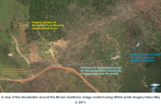
Tuscaloosa, Alabama EF4 - 04/27/2011
Path length: 80.68 miles
Fatalities: 64

Injuries 1,500

This tornado has been covered extensively on this site, including the two write-ups (below) I did on it a few months ago. Tornado Talk has an 8 part summary of it, so I'll dive even deeper at a later date.

Good lord, this place is an absolute gold mine. Some of you should be getting paid for this level of research.

Here's some pics I found of Tuscaloosa:


View attachment 34641
View attachment 34643
View attachment 34646
View attachment 34644
View attachment 34647
View attachment 34645
View attachment 34648

View attachment 34642View attachment 34649

Excerpt from this article (https://extremeplanet.wordpress.com/tag/tuscaloosa-tornado-damage/) :

"Rows of homes on both sides of Alpine Street were wiped cleanly away, along with a retail store and another business to the south with steel beams twisted and bent at those locations. Vehicles were lofted long distances, wind-rowing occurred as seen in the aerial, along with extensive tree debarking and partial ground scouring.

The tornado was near peak intensity as it passed over the Chastain Manor Apartments (pictured by josh above), where two residents died. A survey team headed by the National Science Foundation considered the damage to the newly built apartment complex to be of EF5 intensity (LaDue, Marshall, 2011). Two additional survey teams, however, considered it to be “high-end” EF4 damage. The southern building’s second floor, which was at ground level on the uphill side of the complex, was swept cleanly away to its cement floor. The structural anchorage was to code, but not considered “superior” in quality.

Damage in Alberta City was more impressive than the worst damage caused by some official EF5s, such as the Greensburg, Kansas, tornado of 2007. One inherent limitation with tornado damage scales is the lack of emphasis on wind duration – a variable which, with the addition of multiple vortices and transient wind features, is nearly impossible to calculate. Considering the small size and fast movement of the Tuscaloosa tornado, it is quite likely the tornado had winds significantly higher than other large and more slow-moving EF5 tornadoes. The four tornadoes that were awarded EF5 ratings during the 2011 Super Outbreak, however, were unusually powerful and caused noticeably more intense damage than the Tuscaloosa event, so an EF4 rating may have seemed most appropriate in context."

You can see it in one of the satellite images @joshoctober16 shared but here's another pic I found. One of them was thrown 100 feet uphill:

View attachment 34650

Pretty impressive considering they were 100 feet tall, weighed 68,000 pounds, and were anchored to concrete footers (which were damaged beyond repair)! Here's a picture of the coal train that was tossed.

View attachment 34651

"One car, which weighed 36 tons, was hurled 120 yards (visible at center). Eyewtiness statements suggest the car was thrown in one toss and not rolled (Knupp et al., 2012). This is the longest distance a railroad car has ever been moved by a tornado and possible evidence of EF5 winds."

This study by Iowa State determined it could've been done by 145 MPH winds, but I think they took some pretty huge leaps in logic to reach that conclusion.

Here's Tim Marshall and Jim Ladue's explanation on the rating for the Chastain Manor Apartments and Clubhouse:


View attachment 34652
View attachment 34653
View attachment 34654

This slide fails to mention that the building’s second floor was at ground level on the uphill side of the complex and was swept cleanly away to its cement floor. The structural anchorage was to code, but not considered “superior” in quality.

Here's the Clubhouse explanation

View attachment 34655

Three members from the National Science Foundation (NSF) rated it EF5 due to
1. Slab swept clean indicates greater than
DOD=6.
2. Nail spacing to code (6" OC)
3. Quality Southern Pine, large shearwalls
4. Similar construction to houses where a higher
DOD is available

View attachment 34657

Seems pretty wild that this is considered "too much debris around", considering most of it is completely gone (maybe in the pond?), but what do I know....

Edit:

Definitely preaching to the choir on this one being underrated, but figured I should still share what I found from everyone else's research in one concise post and document it in this thread

New Rating: F5

Reasons: Everything. Tossed a train car further than one has ever been tossed, snapped a 68,000 pound railroad trestle from its foundation and lifted it 100 feet uphill. Well-built structures blown away. Incredible phenomena. Significant debarking. Fujita would've undoubtedly rated this F6 if it happened in 1974 instead of 2011.

That's all of Alabama. Now onto Illinois.

Coal City-Braidwood, Illinois EF3 - 06/22/2015
Path Length: 16.26 miles
Fatalities: 0

Injuries: 7

This was one of 10 tornadoes produced by the same supercell, and the most powerful. As the tornado entered Coal City, dozens of homes were heavily damaged , and three were completely destroyed. According to the NWS summary, "Two of these homes were well built and had at least part of their structures bolted down to the foundation with bolts secure by nuts."

House 1:
1755711930292.png

House 2 (2 stories and well built):
1755711979019.png


House 3 (well built): Entire structure destroyed and pushed off foundation/bottom level.

1755712173406.png
1755712279131.png
1755712586317.png

This is what surveyors called "Very high-end EF3 damage" for some reason, and is the perfect example of how we've lost the plot with tornado ratings.

New Rating: F4

Reason: Strong framed homes blown over
 
Tuscaloosa, Alabama EF4 - 04/27/2011
New Rating: F5


Reasons: Everything. Tossed a train car further than one has ever been tossed, snapped a 68,000 pound railroad trestle from its foundation and lifted it 100 feet uphill. Well-built structures blown away. Incredible phenomena. Significant debarking. Fujita would've undoubtedly rated this F6 if it happened in 1974 instead of 2011.
This is one I’ve come around on. If El Reno 2011 got EF5 because of a non-traditional DI, then Tuscaloosa should’ve gotten it from the train trestle.

Also this tidbit from @UK_EF4 seems to be believable in my opinion:


Anecdotes and stories which are difficult to confirm should always be taken with a grain of salt, obviously, but I have heard some questionable stories relating to Tuscaloosa's EF4 rating and Tim Marshall.

Now, as I said, it would obviously be very hard to confirm this, but a friend of mine is in some sort of forum or server with quite a few meteorologists, including some in the NWS. What they claimed is that NWS BMX had Tuscaloosa surveyed as an EF5, ready to release the rating via PNS. Apparently, Tim Marshall and some of his associates entered the NWS building, and went into Jim Stefkovich's office (the former head of BMX) and convinced him to lower the rating to an EF4. Apparently one the receptionist who was also one of the forecasters at BMX tried to get them to leave, but he walked right in. The final rating was EF4, obviously.

The implications of this are fairly large, and I would be ready to believe BMX had Tuscaloosa ready to go as an EF5. In fact I remember reading somewhere there was one survey team out of roughly four or five that did in fact say they found EF5 damage. However, I just think its important to be careful about the Tim Marshall side of the story, as like I said this could be a rumor, over exaggerated, miscommunicated etc. I am mainly sharing this in case anyone here happens to know anything extra or has any thoughts. I personally respect Tim Marshall, think he has contributed a lot in the past to rating. I don't think he really has a particular bias in being conservative - just look at the Marietta tornado which he rated EF4 based on the warehouse damage, which I personally found shocking and if anything was slightly overdone. He probably just is stubborn in changing an opinion once he's made it.

I think most likely his team presented evidence on some of the structural flaws they found in their review of the damage and Jim went with their opinion.
 
I think both are definitely at least F4s. The Fujita scale is intentionally and explicitly designed to classify the total collapse of homes as F4 damage. A lot of people are resistant to rating collapsed structures above F3 because of how long it's been like this now, but it was never the intent of either scale.

View attachment 46234View attachment 46237

The scales are designed to categorize damage by severity. Collapse of upper stories or multiple walls knocked over is a 3, total collapse is a 4, and swept away is 5. The wind speeds are just what we believe it requires to cause that type of damage. This is how a true damage scale is supposed to work. If a tornado is rated F4 you automatically know it's the type that razed homes to the ground. Notice how the construction description on the EF scale says nothing about anchor bolts, toe nails, or foundation type. "All walls" was always supposed to be EF4 damage (for any home) with a lower bound available for extreme circumstance of poor construction or degradation.

There was a period where the F scale was truly science based and contextual feats were also categorized to determine true winds speeds, which was an attempt to take the scale beyond something purely damage based into a more reliable and accurate tool. This is the period I'm most interested in. I'm still trying to decide on which mindset to prioritize, though. Do I consistently categorize damage, or consistently categorize true wind speeds?
Fair. You've convinced me.

I'd also suggest the answer to your question could be both!
 
Back
Top