• Welcome to TalkWeather!
    We see you lurking around TalkWeather! Take the extra step and join us today to view attachments, see less ads and maybe even join the discussion.
    CLICK TO JOIN TALKWEATHER

Discussion of April 27, 2011 Outbreak

Messages
2,753
Reaction score
4,292
Location
Madison, WI
That early round by itself also produced almost half as many tornadoes as the Super Outbreak! That alone would have more than verified the high risk. I think that has to be historically unprecedented from a predawn QLCS.
 

Tennie

Member
Messages
935
Reaction score
762
Location
Tennessee
That early round of storms killed 6 people, knocked out power, cable, and weather radio repeaters. Even cell service was spotty. I can't help but think that played a role in the deaths and injuries that occurred later on. Was that early morning round predicted to be as bad as it was? What about the late morning round that hit N AL? I don't remember the hearing or reading that either before or after.

I've read through some of the archived AFDs from the Alabama CWAs (which are archived somewhere on the Iowa Mesonet site; can't remember where off the top of my head, unfortunately). In them there's mention of some possibilities for severe weather coming through in the early morning hours, but they didn't seem overly concerned about that (which seems to me that the storms were anticipated but their severity was greatly underforecasted).

One can only wonder what factor(s) caused the forecasts to be so grossly off regarding the severity of the morning event...
 

locomusic01

Member
Messages
1,350
Reaction score
3,758
Location
Pennsylvania
can't remember where off the top of my head, unfortunately

Here you go.

Also, I know it's been posted multiple times before, but the afternoon AFD from BMX still gives me chills knowing what we know about how things unfolded that day.

AREA FORECAST DISCUSSION
NATIONAL WEATHER SERVICE BIRMINGHAM AL
347 PM CDT WED APR 27 2011

...SIGNIFICANT SEVERE WEATHER OUTBREAK ONGOING...

.DISCUSSION...

A VERY DANGEROUS SITUATION IS CURRENTLY UNFOLDING ACROSS CENTRAL
ALABAMA...AND SUPERCELLS HAVE ERUPTED ACROSS THE NORTHERN AND
WESTERN SECTIONS OF THE CWA THIS AFTERNOON. A FEW TORNADOES HAVE
ALREADY TOUCHED DOWN...AND REPORTS OF MAJOR DAMAGE ARE STARTING TO
COME IN. THE 18Z SPECIAL SOUNDING THAT WAS PERFORMED PRESENTS A
DESTRUCTIVE SETUP...WITH 2700J/KG OF CAPE...EXTREMELY STEEP LAPSE
RATES...AND DRY AIR ALOFT. 0-3 KM HELICITY VALUES ARE ALMOST 700.
THE PARAMETERS WILL ONLY WORSEN AS WE GO THROUGHOUT THE REST OF
THE AFTERNOON AND EVENING. THE TIME FRAME FOR THE WORST SEVERE
WEATHER WILL PERSIST THROUGH THE EARLY AFTERNOON HOURS FOR
NORTHWEST SECTIONS OF THE STATE...ROUGHLY FROM 2PM TO
8PM...CENTRAL PORTIONS OF THE STATE...INCLUDING THE BIRMINGHAM
METRO AREA...FROM 4PM TO 10PM...AND THE SOUTHEAST SECTIONS FROM
6PM TO 2AM. I CANNOT STRESS HOW SERIOUS THIS SITUATION IS. DO
WHATEVER YOU CAN TO PROTECT YOUR LIFE AND PROPERTY NOW...YOUR LIFE
MAY DEPEND ON IT! ALL WEATHER WILL CLEAR THE AREA AFTER 6Z
TONIGHT...SO THE CLEANUP PROCESS CAN BEGIN.
 

Helicity

Member
Messages
32
Reaction score
23
Location
Huntsville, AL
I'm sure it's been posted somewhere before on the old site, but there is a great scientific write up of the 4/27 event done by UAH and other researchers available through BAMS. For those interested, you can view it here: http://journals.ametsoc.org/doi/abs/10.1175/BAMS-D-11-00229.1


I also have a .pdf version in case access on the site is limited, but it's currently too large to attach to this post.
 
Messages
78
Reaction score
39
Location
Center Point Alabama
I will never forget telling my producers that we need to lead with weather that Sunday night, for a possible event on Wednesday. I got that look of "you crazy?". The last time I saw them they remarked at how well they remember that conversation and how things were as bad as I told them off air....while I did use some strong wording, I probably didn't go as far as I should on air...but again, it was 3 days away,
The forecasting by all local mets in Birmingham was surreal as early as Monday. Usually with severe threats you would hear them say "threats are: large hail, damaging wind, and isolated tornadoes" wash, rinse, repeat. Well as early as Monday just about everyone had Tornadoes as the number one threat even the more conservative meteorologists were saying that. That alone should have gotten people's attention.
 

ARCC

Member
Messages
503
Reaction score
309
Location
Coosa county
In the past about this time six years ago, the reality of the situation begins to unfold. It is amazing watching the posts come in almost if it were live.
 
Messages
40
Reaction score
4
Location
Town Creek, Al
A gentleman said the tornado looked like a giant octopus coming over the mountain from Oak Grove into Mount Hope.

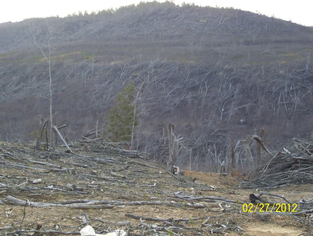
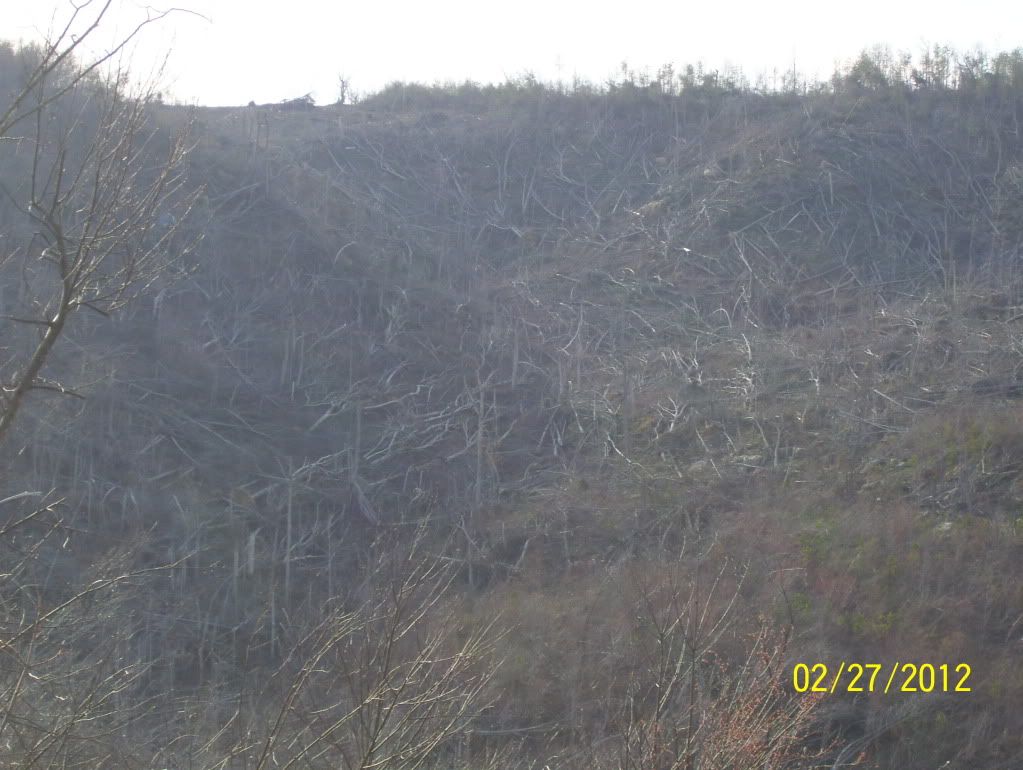
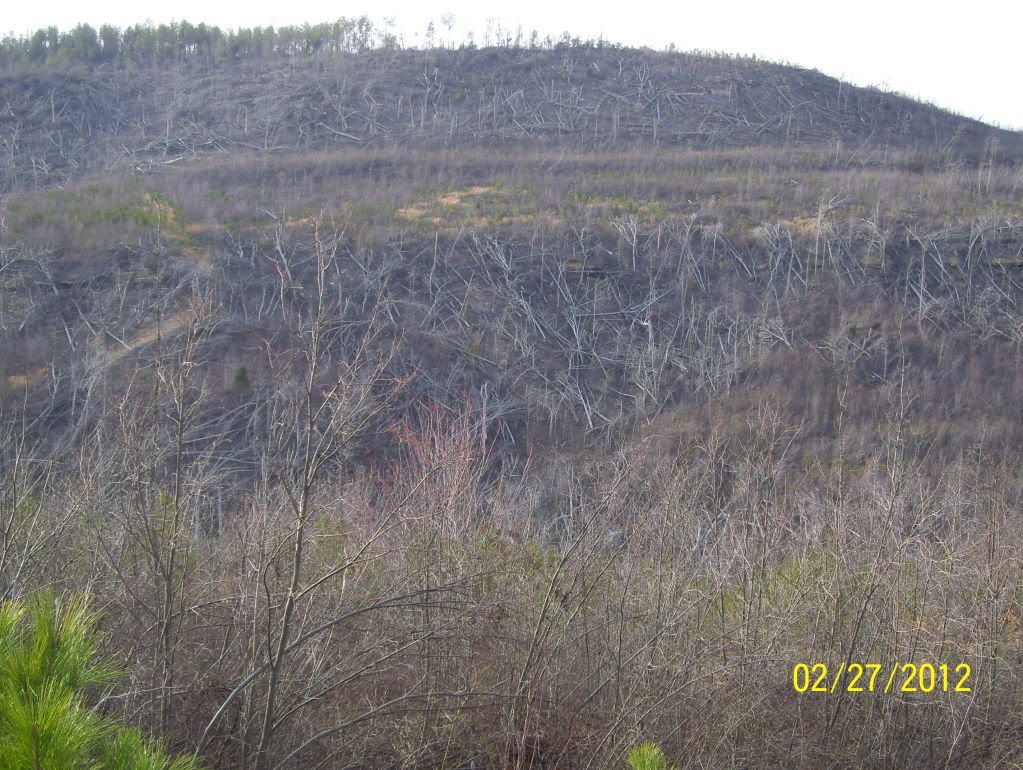
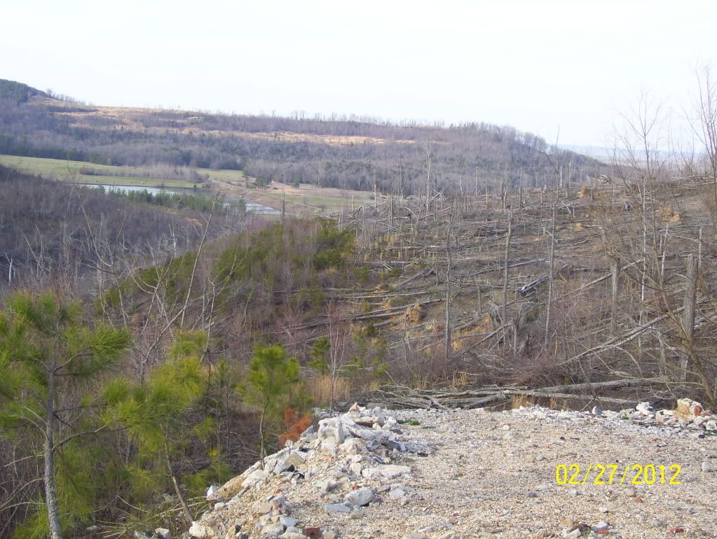
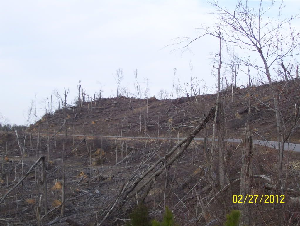
Now grown massive, the storm shaved the trees from the hills at the northern edge of Bankhead Forest, coming to a precipice overlooking the valley that gives way to Mount Hope.

Most trees snapped near the base. But hundreds of pines were doubled over, treetops attached but resting on the ground, trunks twisted around five and six times, until the wood turned soft and slack like taffy.

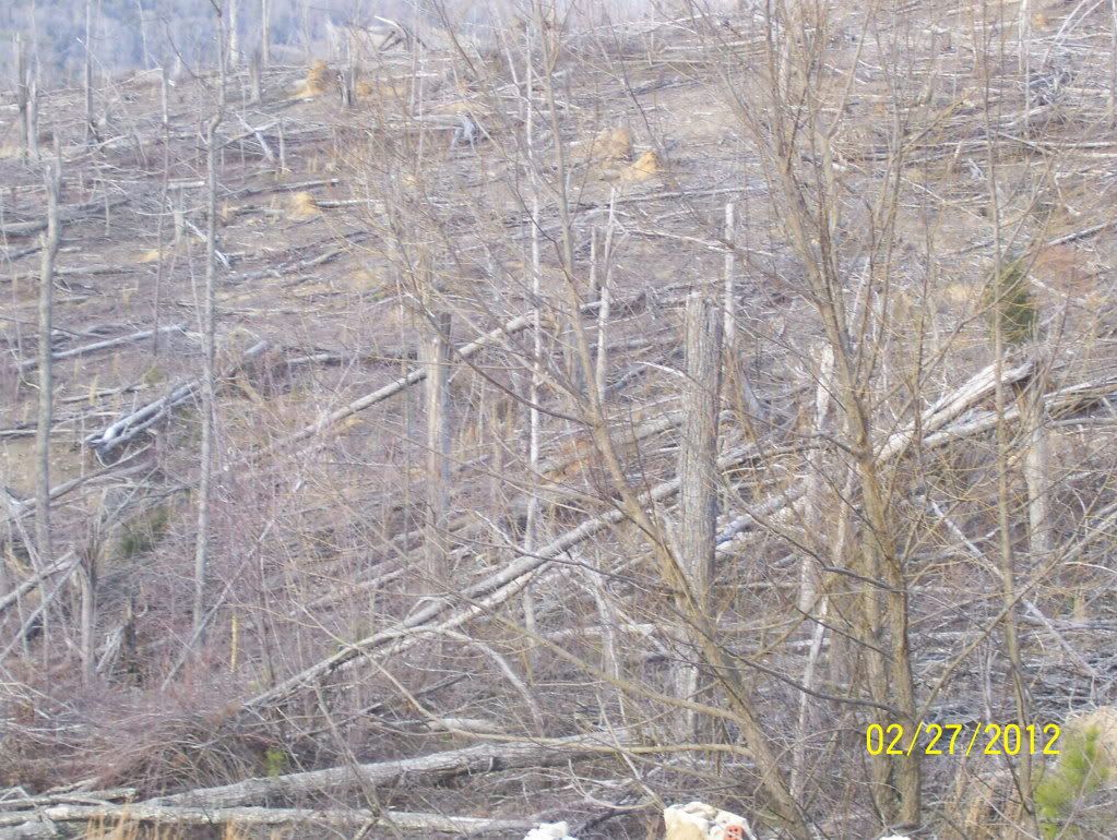
In the valley below, the carcasses of tens of thousands of birds and the tin of the poultry houses had been bulldozed together and set aflame. Dozens more dead chickens were piled by the roadside, while thousands of birds wandered freely through the fields. These pictures were taken about 10 months later.
100_0299.jpg
 
Last edited:

Brent

Member
Messages
118
Reaction score
18
Location
DFW Texas
I had stayed up for the morning round entering West Alabama and I never expected it to be that bad... I even remember remarking to some friends that this was going to be a really long day when those storms came in so intense in the predawn hours.

I pretty much knew the main event would be a lot of doom going into the day before, but I never envisioned the scale of just how much doom it would be, and yeah I have no doubt the morning round made the main event much worse.

We got lucky south of Anniston(between the EF4 in Ohatchee and the EF4 on Lake Martin), but we had some of the most ridiculous lightning I had ever seen and my dad was beating on my door asking where the tornado was... and it wasn't even a tornadic cell and I just remember saying "you can tell these storms killed a lot of people"
 

Blizzzzznado

Member
Messages
11
Reaction score
0
Location
Cartersville, GA
Thank you all for running the posts in real time on the archive thread, amazing it has been 6 years since that outbreak. Got to give credit to post #155, which I posted below, to Henry Margusity calling for over 200+ tornadoes. I remember thinking it would be bad as it got closer, but never thought it would be 200+ tornadoes.

bingcrosbyb
Posted 25 April 2011 - 11:19 AM

Just took a peek at Accuweather and noticed Henry Margusity calling for "extreme" weather the next 3 days in the south/mid-south. Thinks there will be 200+ tornadoes this week. Not sure where he gets his numbers.
 
Messages
40
Reaction score
4
Location
Town Creek, Al
On the 19th Henry predicted more than 300 tornadoes and took quite a bit of ribbing for it but his numbers were right. His location was off but not bad for eight days out.
"On Tuesday, April 19, Henry Margusity, senior meteorologist for AccuWeather.com, predicted that there would be over 300 tornadoes in the following two weeks in an area including East Oklahoma, North Mississippi, Tennessee, Ohio, Indiana and Illinois."

Read more: Daily Corinthian - Particularly dangerous weather looms
 

Fred Gossage

Member
Meteorologist
PerryW Project Supporter
Messages
596
Reaction score
2,096
Location
Florence, AL
I've read through some of the archived AFDs from the Alabama CWAs (which are archived somewhere on the Iowa Mesonet site; can't remember where off the top of my head, unfortunately). In them there's mention of some possibilities for severe weather coming through in the early morning hours, but they didn't seem overly concerned about that (which seems to me that the storms were anticipated but their severity was greatly underforecasted).

One can only wonder what factor(s) caused the forecasts to be so grossly off regarding the severity of the morning event...

Looking back on things now, it really seems like a lot of the smaller scale details that help the morning QLCS become so intense (as well as produce as many tornadoes as it did in north central Alabama) was the development of the mesoscale convective vortex. That's a smaller scale feature that really can't be modeled well until maybe a few hours ahead of time by the higher resolution convection allowing models... and even then, we all know how well they sometimes don't perform. That's not something that was exactly driven by the large scale environment. Sure, the larger scale environmental CAPE and shear supported severe storms and tornado potential that morning, but you wouldn't expect 70-something tornadoes with five of them EF3 (one almost rated EF4). The morning QLCS alone would've verified a High Risk (driven by a tornado threat, not wind).
 

maroonedinhsv

Member
Messages
622
Reaction score
470
Location
Harvest, AL
Not all meteorologists told the public that it was going to be historic. Brad Huffines is one notable example, and as you follow the thread, you may just get to relive his blunder(s).
(time-sensitive) The outbreak thread has reached the point where posters are questioning Huffines's approach/forecast.
 

Mike S

Administrator
Staff member
Administrator
Moderator
PerryW Project Supporter
Messages
1,991
Reaction score
1,117
Location
Meridianville, Al
Special Affiliations
  1. SKYWARN® Volunteer
I could be wrong, but I always thought Huffines was a product of the direction his station wanted to take when it comes to severe weather. I got the sense that 31 wanted to stand apart from 48 and 19 by "keeping it simple" or whatever terminology they used at the time. Huffines wasn't always like that when he first came to 31 and I was personally a fan, but it seemed as though station management wanted to carve out their own niche in the local weather community.

4/27/2011 did teach us that 31 could no longer be taken seriously when it came to severe weather and that stuck with them for several years. They're back to responsibly reporting the weather now.
 

Fred Gossage

Member
Meteorologist
PerryW Project Supporter
Messages
596
Reaction score
2,096
Location
Florence, AL
I think that's the case too, at least to some extent.... but even after he left 31, he had that same general tone about him (but maybe not quite to the extreme he showed on 4/26/11 about what was coming the next day).... but maybe that was also from years of conditioning his presentation to fit that mold at WAAY.
 
Back
Top