Equus
Member
Capping extent was quite evident on the 00z soundings from Jackson and New Orleans so perhaps they wanna see where that's at from BMX etc on the 12z soundings, will largely determine what kind of open warm sector development we get
Follow along with the video below to see how to install our site as a web app on your home screen.
Note: This feature may not be available in some browsers.

HRRR is seeming very consistent about pre-frontal discrete stuff as of its 14Z run, especially focused on parts of AL NW of I-59 and it definitely performed well for yesterday's event, so.Yeah Clancy, there are plenty indications for pre-frontal activity in the warm sector. CAPE and shear look supportive of a significant tornado risk with the storms.
what stands out to me is how HRRR weakens the cells as they push eastward....not sure that is right but it might suggest they aren't really able to overcome the warm air aloft plus they are moving into/fighting the ridge. The HRRR could be wrong about the intensity. The 12z NAM suggests nothing overcomes the cap until but its not a CAM and then the 4k NAM can't be trusted for storm initiation but it shows a healthy cap. A real challenge here that COULD have high consequences.Yeah Clancy, there are plenty indications for pre-frontal activity in the warm sector. CAPE and shear look supportive of a significant tornado risk with the storms.
New Year's spiritBTW, why are all of our profile pics wearing masks that cover our entire face?

That area needs to watch the frontal boundary itself....I don't like the look of the line as it moves south of Bham on some of the models.Will obviously keep an eye on things but I feel a lot better than I did this time yesterday ( a little SE of Birmingham)

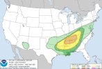
Given the persistence of the subtropical ridge over FL and only
glancing/small height falls through the day, much of the convection
may remain confined to the convection-reinforced frontal zone.
Still, there will be the potential for embedded supercells within a
broken band of storms along the front, and a lower chance for a
few supercells in the open warm sector along diffuse confluence
zones a little south of the front later this afternoon/evening.
Effective bulk shear of 60-70 kt and MLCAPE of 500-1500 J/kg will
conditionally support supercells capable of producing tornadoes,
damaging winds, and marginally severe hail. The prospects for a
couple strong tornadoes will likely hinge on pre-frontal supercell
development that is not entirely undercut by the surface front. This
is most likely from northern portions of MS/AL into middle TN where
effective SRH in excess of 300 m2/s2 should be common late this
afternoon/evening. The frontal convection will spread southeast
through the overnight hours, with a gradually lessening severe
threat and shrinking warm sector centered on AL toward the end of
the period.