
Navigation
Install the app
How to install the app on iOS
Follow along with the video below to see how to install our site as a web app on your home screen.
Note: This feature may not be available in some browsers.
More options
-
Welcome to TalkWeather! We see you lurking around TalkWeather! Take the extra step and join us today to view attachments, see less ads and maybe even join the discussion. CLICK TO JOIN TALKWEATHER
You are using an out of date browser. It may not display this or other websites correctly.
You should upgrade or use an alternative browser.
You should upgrade or use an alternative browser.
Severe WX December 31, 2021 - January 1, 2022 Severe Threat
- Thread starter KevinH
- Start date


Austin Dawg
Member
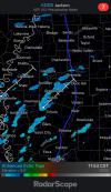
If you look from KGWX you can see them starting to spin
Attachments
Chris3024
Member
Wondering if SPC may shift and increase the threat given the discrete development we're seeing. Also curious how much of the cap is in place atm and how much it will limit these storms.If you look from KGWX you can see them starting to spin
looks like there was a small cell in the areaWondering if SPC may shift and increase the threat given the discrete development we're seeing. Also curious how much of the cap is in place atm and how much it will limit these storms.
Austin Dawg
Member
Could there be too many of them to the point where they start zapping energy from each other so they don't mature into a major super cell?Wondering if SPC may shift and increase the threat given the discrete development we're seeing. Also curious how much of the cap is in place atm and how much it will limit these storms.

I'd imagine that could be a potential issue.Could there be too many of them to the point where they start zapping energy from each other so they don't mature into a major super cell?
There definitely is a cap in the 18z JAN sounding, and mid/upper level temps are fairly marginal. That may contain the threat somewhat.
brianc33710
Member
From what I heard on ABC 33/40 warm air aloft appears to be hampering/lessening severe weather threat today. I guess this could change though.They really need to extend that ENH risk further south, thermos are ahead of schedule in most cases and we're seeing secondary surface low development in Arkansas and the Arklatex, which is going to augment already strong wind fields. This could be a serious event about to unfold given the amount of pre-frontal confluence bands over LA/MS right now.
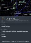
Fresh MD says Tornado Watch likely for N AL, TN into KY.
SUMMARY...THREAT FOR DAMAGING WIND GUST AND TORNADOES CONTINUES
ACROSS CENTRAL KY AND MIDDLE TN WITHIN TORNADO WATCH 3. THIS THREAT
WILL PERSIST DOWNSTREAM INTO MORE OF CENTRAL KY, MIDDLE TN, AND
NORTHERN AL, WHERE A WATCH WILL LIKELY BE NEEDED.
DISCUSSION...RECENT OBSERVATIONS PLACE THE OUTFLOW BOUNDARY FROM
ABOUT 20 MILES SOUTH OF LEX SOUTHWESTWARD TO JUST SOUTHEAST OF BWG,
CONTINUING SOUTHEASTWARD THROUGH WESTERN TN TO ABOUT 20 MILES
SOUTHEAST OF MEM. NUMEROUS SHALLOW BUT STRONG/ORGANIZED CELLS HAVE
DEVELOPED ALONG THIS OUTFLOW BOUNDARY AND LIGHTNING HAS BECOME
SLIGHTLY MORE FREQUENT OVER THE LAST HOUR. GENERAL TREND WITH THE
STRONGER STORMS DEVELOPING WITHIN THE LINE IS FOR AN INITIALLY
CELL-IN-LINE STRUCTURE WITH A STRONG, MORE ORGANIZED UPDRAFT. THIS
MORE CELLULAR STRUCTURE THEN RELATIVELY QUICKLY TRENDS TOWARDS
BOWING LINE SEGMENTS AS THE OUTFLOW BOUNDARY CONTINUES PUSHING
SOUTHEASTWARD. AS SUCH, A RELATIVELY BRIEF PERIOD FOR TORNADOGENESIS
EXISTS BEFORE THE STORMS THEN TRANSITION TO MORE OF A DAMAGING WIND
THREAT. INITIAL, MORE DISCRETE DEVELOPMENT HAS ALSO OCCURRED
SPORADICALLY AHEAD OF THE LINE, WITH A LONGER DURATION OF MORE
CELLULAR STRUCTURE CONTRIBUTING TO A SLIGHTLY GREATER TORNADO RISK.
THESE STORMS ALSO TREND TOWARDS BOWING LINE SEGMENTS AS THE OUTFLOW
OVERTAKES THEM.
THIS OVERALL PATTERN IS EXPECTED TO CONTINUE FOR AT LEAST THE NEXT
FEW HOURS AS THE OUTFLOW PUSHES QUICKLY EASTWARD/SOUTHEASTWARD.
CURRENT MOTION PLACES THE OUTFLOW NEAR THE EDGE OF TORNADO WATCH 3
BY 1930Z-2000Z. WINDS ARE CURRENTLY A BIT MORE VEERED DOWNSTREAM,
BUT VERTICAL SHEAR REMAINS VERY STRONG. AS SUCH, SUPERCELLS CAPABLE
OF DAMAGING WIND GUSTS AND TORNADOES REMAIN POSSIBLE AND A
DOWNSTREAM WATCH WILL LIKELY BE NEEDED.
- Moderator
- #196
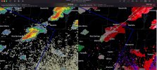
I’ll be able to see that cell soon.The cell heading into the far NW portion of Franklin Co., AL is hooking a bit.
View attachment 11400
Kragg
Member
Some of the storms in north MS are starting to get a bit taller with a good tilt
HRRR soundings suggest the cap erodes a bit in the next hour or two near the Miss/Al broder, still hanging closer to I65
I’ll be able to see that cell soon.
If you can get some images and post them here, that would be interesting to see. If, not, lets us know how things go regardless!